Real-time mapping accuracy improvements with photodiodes
AUG 21, 20259 MIN READ
Generate Your Research Report Instantly with AI Agent
Patsnap Eureka helps you evaluate technical feasibility & market potential.
Photodiode Mapping Evolution and Objectives
Photodiode mapping technology has undergone significant evolution since its inception, driven by the increasing demand for high-precision real-time mapping in various applications. The journey began with simple light detection and has progressed to sophisticated spatial mapping techniques that offer unprecedented accuracy and speed.
In the early stages, photodiodes were primarily used for basic light detection and measurement. As technology advanced, researchers and engineers recognized the potential of photodiodes for spatial mapping applications. This led to the development of single-point mapping systems, where a single photodiode would be used to scan an area sequentially, building a map point by point.
The next major milestone was the introduction of array-based photodiode systems. These arrays allowed for simultaneous data collection from multiple points, significantly increasing mapping speed and resolution. However, early array systems were limited by processing power and data handling capabilities, constraining their real-time performance.
Recent advancements in microprocessor technology and signal processing algorithms have revolutionized photodiode mapping. Modern systems can now process vast amounts of data in real-time, enabling the creation of high-resolution, dynamic maps. The integration of machine learning and artificial intelligence has further enhanced the accuracy and adaptability of these systems, allowing them to compensate for environmental variations and noise.
The current frontier in photodiode mapping technology focuses on improving real-time accuracy. This involves enhancing the sensitivity and response time of photodiodes, developing more sophisticated noise reduction techniques, and implementing advanced data fusion algorithms. The goal is to create mapping systems that can provide highly accurate spatial information with minimal latency, even in challenging environments.
Looking ahead, the objectives for photodiode mapping technology are multifaceted. One key aim is to further miniaturize the systems while increasing their resolution and field of view. This would enable the integration of high-performance mapping capabilities into smaller devices, opening up new applications in fields such as robotics, autonomous vehicles, and wearable technology.
Another important objective is to improve the energy efficiency of photodiode mapping systems. As these systems find their way into more portable and autonomous devices, minimizing power consumption without compromising performance becomes crucial. This involves not only optimizing the photodiodes themselves but also developing more efficient processing algorithms and hardware architectures.
Market Demand for Precise Real-time Mapping
The demand for precise real-time mapping has been growing exponentially across various industries, driven by advancements in technology and the increasing need for accurate spatial data. This market segment has seen significant expansion in recent years, with applications ranging from autonomous vehicles and robotics to urban planning and environmental monitoring.
In the automotive sector, the push towards autonomous driving has created a substantial market for high-precision mapping technologies. As vehicles become more automated, the need for real-time, centimeter-level accuracy in positioning and mapping has become critical. This demand is not limited to passenger vehicles but extends to commercial fleets, logistics, and public transportation systems.
The construction and infrastructure industries have also shown a strong appetite for precise real-time mapping solutions. These technologies enable more efficient project planning, execution, and monitoring. The ability to create and update digital twins of construction sites in real-time has become a valuable asset for project managers and engineers, leading to improved safety, reduced costs, and faster project completion times.
In agriculture, precision farming techniques rely heavily on accurate real-time mapping. Farmers and agricultural companies are increasingly adopting technologies that allow for precise monitoring of crop health, soil conditions, and equipment positioning. This trend has led to a growing market for mapping solutions that can integrate with various sensors and agricultural machinery.
The drone industry has emerged as another significant driver of demand for precise real-time mapping. Applications in surveying, inspection, and aerial photography require highly accurate positioning and mapping capabilities. As regulations around drone usage continue to evolve, the market for advanced mapping technologies in this sector is expected to expand further.
Urban planning and smart city initiatives have also contributed to the growing demand for precise mapping solutions. Cities worldwide are investing in technologies that enable better management of resources, traffic flow, and urban development. Real-time mapping plays a crucial role in these efforts, providing city planners and administrators with up-to-date information for decision-making.
Environmental monitoring and disaster management represent another area where precise real-time mapping is in high demand. Governments and organizations require accurate, timely data for tracking natural disasters, monitoring climate change effects, and managing conservation efforts. The ability to quickly map and assess affected areas during emergencies has become increasingly important for disaster response teams.
As industries continue to digitize and automate their operations, the market for precise real-time mapping is expected to grow further. The integration of technologies such as 5G, edge computing, and artificial intelligence is likely to drive innovation in this field, creating new applications and expanding existing markets. This trend suggests a robust and expanding market for technologies that can improve real-time mapping accuracy, including advancements in photodiode-based systems.
Current Challenges in Photodiode Mapping Accuracy
Despite significant advancements in photodiode technology, several challenges persist in achieving high-precision real-time mapping accuracy. One of the primary obstacles is the inherent noise in photodiode sensors, which can significantly impact the quality of data collected. This noise, including shot noise, thermal noise, and 1/f noise, introduces uncertainties in measurements, particularly in low-light conditions or when detecting weak signals.
Another critical challenge is the limited dynamic range of conventional photodiodes. In real-time mapping applications, the sensor must accurately capture both bright and dim areas within the same scene. However, current photodiodes often struggle to maintain linearity across a wide range of light intensities, leading to potential loss of detail in extreme lighting conditions.
The response time of photodiodes also presents a significant hurdle in real-time mapping scenarios. While photodiodes are generally known for their fast response, achieving the ultra-high speeds required for precise real-time mapping in rapidly changing environments remains challenging. This limitation can result in motion blur or inaccurate positioning in dynamic mapping applications.
Temperature sensitivity is another factor affecting the accuracy of photodiode-based mapping systems. Fluctuations in ambient temperature can alter the performance characteristics of photodiodes, leading to drift in measurements over time. This issue is particularly problematic in outdoor or industrial environments where temperature control is difficult to maintain.
The spatial resolution of photodiode arrays is also a limiting factor in achieving high-accuracy mapping. Current technology often requires a trade-off between sensor size and resolution, with higher resolution arrays typically resulting in larger, more expensive devices. This constraint can limit the applicability of photodiode-based systems in compact or cost-sensitive applications.
Calibration and consistency across multiple photodiodes in an array pose additional challenges. Ensuring uniform response and alignment among numerous sensors is crucial for accurate mapping but can be complex and time-consuming. Variations in manufacturing processes can lead to discrepancies between individual photodiodes, necessitating sophisticated calibration techniques.
Lastly, the integration of photodiodes with other sensing technologies and data processing systems presents ongoing challenges. Achieving seamless fusion of photodiode data with information from other sensors, such as IMUs or GPS, is essential for comprehensive and accurate mapping. However, synchronization issues and data compatibility can complicate this integration process, potentially reducing overall system accuracy.
Existing Real-time Mapping Accuracy Solutions
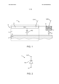
01 Improved photodiode structure for enhanced mapping accuracy
Advanced photodiode designs incorporate specialized structures to improve mapping accuracy. These may include optimized doping profiles, novel junction configurations, or integrated light-guiding elements. Such improvements can enhance sensitivity, reduce noise, and increase spatial resolution, leading to more precise mapping capabilities.- Improved photodiode structure for enhanced mapping accuracy: Advanced photodiode designs incorporate structural improvements to enhance mapping accuracy. These include optimized doping profiles, reduced dark current, and improved quantum efficiency. Such enhancements result in better signal-to-noise ratios and increased sensitivity, leading to more precise spatial mapping in various applications.
- Integration of photodiodes with signal processing circuitry: Integrating photodiodes with on-chip signal processing circuitry improves mapping accuracy by reducing noise and enhancing signal quality. This approach allows for immediate amplification and digitization of the photodiode output, minimizing signal degradation and improving overall system performance in mapping applications.
- Array configurations for high-resolution mapping: Photodiode arrays in various configurations enable high-resolution spatial mapping. These arrays can be linear, 2D, or even 3D, allowing for detailed coverage of the target area. Advanced array designs incorporate features like variable pixel sizes or adaptive sensing elements to optimize mapping accuracy across different scales and conditions.
- Wavelength-specific photodiodes for selective mapping: Developing photodiodes sensitive to specific wavelengths enables selective mapping of particular features or materials. This approach uses tailored bandgap materials or optical filters to achieve wavelength selectivity, allowing for more accurate mapping of specific targets while minimizing interference from other light sources.
- Calibration and compensation techniques for improved accuracy: Implementing advanced calibration and compensation techniques enhances the mapping accuracy of photodiode systems. These methods include temperature compensation, dark current subtraction, and non-linearity correction. By accounting for various sources of error and drift, these techniques ensure consistent and precise mapping performance across different operating conditions.
02 Array configurations for high-resolution mapping
Photodiode arrays are designed with specific configurations to maximize mapping accuracy. This may involve optimizing pixel size, pitch, and arrangement to achieve higher spatial resolution. Advanced array designs can also incorporate on-chip processing elements or novel readout architectures to improve overall system performance and mapping precision.Expand Specific Solutions03 Integration of signal processing techniques
Incorporating advanced signal processing techniques directly into photodiode systems can significantly enhance mapping accuracy. This may include on-chip analog-to-digital conversion, noise reduction algorithms, or adaptive gain control. These integrated processing capabilities can improve signal quality and enable more accurate interpretation of photodiode outputs for precise mapping applications.Expand Specific Solutions04 Specialized coatings and materials for improved performance
The use of specialized coatings and materials in photodiode construction can enhance their mapping accuracy. This may involve anti-reflective coatings, novel semiconductor materials, or advanced passivation techniques. These improvements can increase quantum efficiency, reduce dark current, and enhance overall sensitivity, leading to more accurate mapping results.Expand Specific Solutions05 Calibration and compensation techniques
Implementing sophisticated calibration and compensation techniques can significantly improve the mapping accuracy of photodiode systems. This may include methods for temperature compensation, dark current subtraction, or non-uniformity correction. Advanced calibration algorithms and real-time adjustment capabilities can help maintain high accuracy across varying environmental conditions and over the lifetime of the device.Expand Specific Solutions
Key Players in Photodiode Mapping Industry
The real-time mapping accuracy improvements with photodiodes market is in a growth phase, driven by increasing demand for high-precision sensing in various industries. The global market size is expanding, with projections indicating significant growth in the coming years. Technologically, the field is advancing rapidly, with key players like Sony, Samsung, and Sharp leading innovation. These companies are developing more sensitive and accurate photodiode sensors, integrating them with advanced signal processing algorithms. Emerging players such as Mechaless Systems and Goodix Technology are also contributing to technological advancements, particularly in miniaturization and power efficiency. The competitive landscape is characterized by a mix of established electronics giants and specialized sensor manufacturers, all vying to enhance real-time mapping capabilities across diverse applications.
Sony Group Corp.
Technical Solution: Sony has made significant advancements in photodiode technology for real-time mapping applications. Their Exmor R CMOS image sensors feature back-illuminated structures that increase light sensitivity and reduce noise, improving mapping accuracy in low-light conditions[10]. Sony's stacked CMOS sensor design integrates high-speed signal processing circuits directly beneath the photodiode layer, enabling faster readout speeds and real-time data processing for mapping applications[11]. The company has also developed intelligent exposure control systems that dynamically adjust photodiode sensitivity based on scene conditions, enhancing mapping accuracy across diverse environments[12].
Strengths: High-performance image sensors with advanced photodiode designs, strong integration capabilities. Weaknesses: Primary focus on consumer and professional imaging markets may limit specialized mapping applications.
Samsung Electronics Co., Ltd.
Technical Solution: Samsung has developed innovative photodiode technologies to enhance real-time mapping accuracy. Their ISOCELL image sensors incorporate advanced pixel isolation technology, reducing crosstalk between photodiodes and improving overall sensitivity and accuracy[13]. Samsung's Dual Pixel Pro technology uses two photodiodes per pixel for faster and more accurate autofocus, which can be adapted for precise distance measurements in mapping applications[14]. The company has also introduced stacked CMOS sensors with integrated DRAM, allowing for high-speed data readout and processing, crucial for real-time mapping performance[15]. Additionally, Samsung's research into curved sensor designs aims to improve light collection efficiency and reduce distortion in wide-angle mapping scenarios.
Strengths: Advanced pixel technologies, high-speed sensor designs, and potential for curved sensor innovations. Weaknesses: May require significant adaptation from imaging-focused designs to specialized mapping applications.
Innovative Photodiode Designs for Mapping
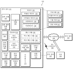
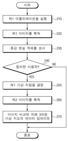
Method for updating 3-dimensional map using image, and electronic device for supporting same
PatentWO2022080869A1
Innovation
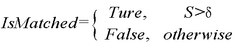
- An electronic device equipped with a camera module, communication circuit, and processor executes an application to acquire images, recognize building features, and update 3D virtual maps by comparing actual images with virtual ones, allowing for real-time updates and improved precision without the need for extensive recalibration or costly data collection.
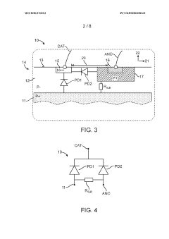
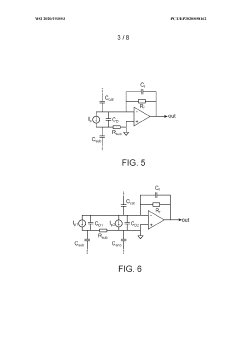
Photodiode and read-out circuit for a photodiode
PatentWO2020193553A1
Innovation
- A photodiode with a lateral structure featuring a semiconductor substrate and layer with laterally offset regions of opposite conductivity types, reducing capacitive couplings and noise amplification, and a readout circuit incorporating a transimpedance amplifier and high-pass filter to enhance signal-to-noise ratio and measurement accuracy.

Environmental Factors Affecting Photodiode Performance
Environmental factors play a crucial role in the performance and accuracy of photodiodes used in real-time mapping applications. Temperature fluctuations significantly impact photodiode sensitivity and dark current. As temperatures rise, the dark current increases exponentially, potentially leading to signal degradation and reduced accuracy in low-light conditions. Conversely, extremely low temperatures can affect the responsivity of the photodiode, altering its spectral response characteristics.
Humidity is another critical factor influencing photodiode performance. High humidity levels can lead to condensation on the photodiode surface, causing light scattering and refraction. This can result in inaccurate light measurements and compromised mapping precision. Additionally, prolonged exposure to moisture may lead to corrosion of the photodiode's electrical contacts, further degrading its performance over time.
Ambient light interference poses a significant challenge in real-time mapping applications. Stray light from various sources, such as sunlight or artificial lighting, can introduce noise and reduce the signal-to-noise ratio of the photodiode output. This interference can lead to errors in distance measurements and object detection, particularly in outdoor or mixed lighting environments.
Dust and particulate matter accumulation on the photodiode surface can attenuate incoming light and alter its spectral characteristics. This can result in reduced sensitivity and inaccurate light measurements, affecting the overall mapping accuracy. Regular cleaning and maintenance of photodiodes are essential to mitigate these effects and ensure consistent performance.
Electromagnetic interference (EMI) from nearby electronic devices or power sources can induce noise in the photodiode signal. This interference can manifest as fluctuations in the output current, leading to erroneous measurements and reduced mapping precision. Proper shielding and filtering techniques are necessary to minimize the impact of EMI on photodiode performance.
Mechanical vibrations and shocks can affect the alignment and positioning of photodiodes within the mapping system. Even slight misalignments can lead to significant errors in distance measurements and object detection. Robust mounting solutions and vibration isolation techniques are crucial for maintaining the stability and accuracy of photodiode-based mapping systems in dynamic environments.
Atmospheric conditions, such as fog, rain, or air pollution, can scatter and absorb light, altering the path and intensity of incoming signals. These factors can significantly impact the range and accuracy of photodiode-based mapping systems, particularly in outdoor applications. Adaptive algorithms and multi-sensor fusion techniques may be necessary to compensate for these environmental variations and maintain mapping accuracy under diverse atmospheric conditions.
Calibration Techniques for Improved Mapping Accuracy
Calibration techniques play a crucial role in improving the mapping accuracy of systems utilizing photodiodes for real-time applications. These techniques aim to minimize errors and enhance the overall performance of the mapping system. One of the primary calibration methods involves the use of reference targets with known reflectance properties. By measuring the response of photodiodes to these targets under controlled conditions, a calibration curve can be established to correct for variations in sensor sensitivity and environmental factors.
Another important calibration technique is the implementation of dynamic range adjustment. This method involves continuously adapting the sensitivity of the photodiodes based on the ambient light conditions and the reflectivity of the surfaces being mapped. By dynamically adjusting the gain and integration time of the photodiodes, the system can maintain optimal performance across a wide range of lighting scenarios, ensuring consistent mapping accuracy.
Multi-point calibration is a sophisticated technique that addresses non-linear responses in photodiode sensors. This approach involves characterizing the sensor's response at multiple points across its operating range, allowing for more accurate compensation of non-linearities. By applying this calibration data during real-time operation, the system can achieve higher mapping accuracy, especially in challenging environments with varying surface properties.
Temperature compensation is another critical aspect of calibration for improved mapping accuracy. Photodiodes are sensitive to temperature fluctuations, which can affect their response characteristics. By incorporating temperature sensors and applying compensation algorithms, the system can adjust for thermal drift, maintaining consistent performance across a range of operating temperatures.
Cross-sensor calibration is essential in systems employing multiple photodiodes for mapping. This technique involves aligning and normalizing the responses of different sensors to ensure consistent measurements across the entire mapping area. By accounting for variations between individual sensors, the system can produce more accurate and cohesive mapping results.
Periodic recalibration is necessary to maintain long-term accuracy in real-time mapping systems. This involves regularly scheduled calibration procedures to account for sensor drift, aging effects, and changes in environmental conditions. By implementing automated recalibration routines, the system can maintain its accuracy over extended periods of operation without manual intervention.
Unlock deeper insights with Patsnap Eureka Quick Research — get a full tech report to explore trends and direct your research. Try now!
Generate Your Research Report Instantly with AI Agent
Supercharge your innovation with Patsnap Eureka AI Agent Platform!