
Method of exploring morphological characteristics of gorge bank slope deep buried underground large karst cave
A technology of large-scale karst caves and morphological characteristics, applied in the direction of measuring devices and instruments, can solve the problems of time-consuming and labor-intensive exploration work, difficult exploration of the properties, morphological characteristics and spatial distribution of cave fillings, and high exploration costs, saving exploration work expenses. , The effect of low unit price of drilling footage and improved exploration accuracy
Patent Information
- Authority / Receiving Office
- CN · China
- Current Assignee / Owner
- Publication Date
- 2016-02-03
- Estimated Expiration
- Not applicable · inactive patent
Smart Images
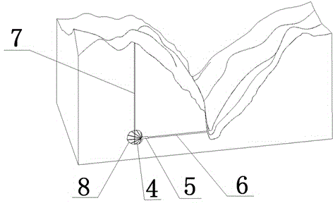
Figure 1 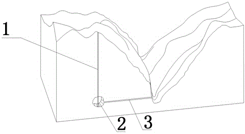
Figure 2
Abstract
Description
Technical field
[0001] The invention relates to a method for exploring the morphological characteristics of deep-buried underground large-scale karst caves on the slope of a canyon, belonging to the technical field of underground-buried karst cave detection on the slope of a karst canyon. Background technique
[0002] With the development of the national economy and socialist construction, a series of karst engineering geological problems have been encountered in the process of major infrastructure construction. For example, a railway bridge is located in the lofty mountains in Liupanshui City, Guizhou Province. The bridge crosses the Beipan River deep-cut gorge at an angle of 80°. The river is strongly undercut, and the bank wall is nearly upright. The left bank where the main pier of the left bank 3# is located (water The end of the city) the cliff is 158m high and upright. There is an inverted rock cavity about 3m high at the bottom of the cliff. The top slope of the cliff has...
Examples
Embodiment 1
[0021] The first embodiment of the present invention: as attached figure 1 As shown, in the Jia Reservoir Project, a ground vertical borehole 7 was drilled at a depth of 158.80~161.50m. The footage was faster, and the yellow clay was brought out by the drilling tool after lifting. According to the common sense of geological drilling in karst areas, preliminary It is judged that there is a karst cave underground. Based on the analysis of the ground geological surveying and mapping results, the karst cave is a buried type filled karst cave. At this time, in order to find out the ground drilling and reveal the karst cave's planar distribution range and filling features, it is necessary to arrange grid-like exploration holes. The grid spacing is 20﹡20m, and the initial estimated number of holes is about 6 holes. Based on a single hole depth of 180m, a total drilling volume of about 1080m needs to be arranged. Estimated at a unit price of 650 yuan / m, the drilling investment is estimat...
Embodiment 2
[0022] The second embodiment of the present invention: as attached figure 2 As shown, in the existing reservoir project, a vertical borehole on the ground was drilled at a depth of 123.30~125.10m when the hole was dropped. According to the common sense of geological drilling in karst areas, it is preliminarily judged that there are karst caves underground, and the results of surface geological surveying and mapping According to the analysis, the cave is a buried filling cave; at this time, in order to find out the ground boreholes to reveal the planar distribution range of the cave and the characteristics of the filling, grid-like exploration boreholes need to be arranged, and the boreholes are arranged at a grid spacing of 20﹡20m. The initial estimated number of drilling holes is about 6 holes. Based on a single hole depth of 130m, a total drilling volume of about 780m needs to be arranged. Estimated at a unit price of 650 yuan / m, the drilling investment is estimated to be abo...