
Image generation method and device based on national geographical relationship
An image generation, national technology, applied in geographic information database, structured data retrieval, resources, etc., can solve problems such as poor image display effect
Patent Information
- Authority / Receiving Office
- CN · China
- Patent Type
- Applications(China)
- Current Assignee / Owner
- Publication Date
- 2021-12-07
Smart Images
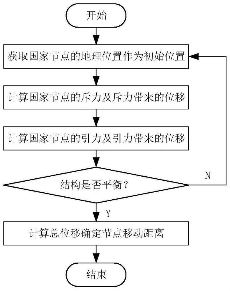
Figure 1 
Figure 2 
Figure 3
Abstract
Description
technical field
[0001] The invention belongs to the technical field of visual analysis of geographical relations, and in particular relates to an image generation method and device based on national geographical relations. Background technique
[0002] Geo-relationships are the core issues of geo-environmental research. Research on geo-relationships between countries aims to establish a network of relationships between countries and analyze its network structure. The current research on geo-relationships mainly analyzes the relevant data through the establishment of calculation models to obtain relatively accurate results, but the expression of the analysis conclusions is still in the form of text reports, data tables, etc. Accurate characterization of complex relationships.
[0003] In the prior art, in December 2018, the author Wen Huiqi and others published an article titled "Research on Visual Analysis of Geo-environment under Big Data" in the journal "Surveying and Map...
Examples
Embodiment Construction
[0059] The specific embodiments of the present invention will be further described below in conjunction with the accompanying drawings.
[0060] Method example:
[0061] This embodiment proposes an image generation method based on the geographical relationship of the country, which specifically includes the following steps:
[0062] Step 1: Take the country as the node (hereinafter referred to as the country node), and use the geographical location and geographical relationship to arrange the country node. Such as figure 1 As shown, the specific steps are as follows:
[0063] (1) Obtain the geographic location coordinates of each country as the initial position of each country node.
[0064] (2) Calculate the magnitude of the gravitational force between the nodes of two countries and the coordinate displacement caused by the gravitational force; calculate the magnitude of the repulsive force between the nodes of two countries and the coordinate displacement caused by the re...