Kalman Filter In Terrain Mapping: Fidelity Measurement
SEP 12, 20259 MIN READ
Generate Your Research Report Instantly with AI Agent
Patsnap Eureka helps you evaluate technical feasibility & market potential.
Kalman Filter Evolution and Terrain Mapping Objectives
The Kalman filter, developed by Rudolf E. Kalman in the early 1960s, represents a significant milestone in estimation theory and has evolved substantially over the decades. Initially designed for linear systems with Gaussian noise, the filter has undergone numerous adaptations to address increasingly complex real-world applications. The evolution trajectory spans from the basic Kalman filter to Extended Kalman Filter (EKF), Unscented Kalman Filter (UKF), and more recent particle-based implementations, each iteration expanding the filter's applicability to non-linear systems and non-Gaussian noise environments.
In terrain mapping applications, the Kalman filter has become instrumental in integrating multi-sensor data to create accurate topographical representations. The primary objective in this domain is to achieve high-fidelity terrain models by effectively managing the inherent uncertainties in sensor measurements while maintaining computational efficiency. This balance is particularly crucial in dynamic environments where real-time mapping capabilities are essential.
The integration of Kalman filtering techniques with modern terrain mapping systems aims to address several key challenges. These include the reduction of measurement noise, compensation for sensor drift, fusion of heterogeneous data sources, and adaptation to varying environmental conditions. The ultimate goal is to enhance the accuracy, reliability, and resolution of digital terrain models while minimizing computational overhead.
Recent technological advancements have further expanded the objectives of Kalman filter applications in terrain mapping. With the proliferation of unmanned aerial vehicles (UAVs) and mobile mapping systems, there is an increasing demand for algorithms that can process high-volume data streams in real-time while maintaining robust performance in GPS-denied environments. This has led to the development of specialized Kalman filter variants optimized for specific terrain mapping scenarios.
The fidelity measurement aspect represents a critical dimension in evaluating Kalman filter performance in terrain mapping. This encompasses quantitative metrics such as root mean square error (RMSE), spatial resolution consistency, and temporal stability of the generated terrain models. Additionally, qualitative assessments focus on the filter's ability to preserve important topographical features while appropriately smoothing noise-induced artifacts.
Looking forward, the technical trajectory points toward increasingly sophisticated implementations that leverage machine learning techniques to enhance the adaptive capabilities of Kalman filters in terrain mapping. These hybrid approaches aim to optimize parameter tuning automatically based on environmental conditions and mission requirements, potentially revolutionizing how we approach high-fidelity terrain reconstruction in challenging scenarios.
Market Analysis for High-Fidelity Terrain Mapping Solutions
The high-fidelity terrain mapping solutions market has experienced substantial growth over the past decade, driven primarily by increasing demands across multiple sectors including defense, urban planning, disaster management, and autonomous vehicle navigation. The global market for advanced terrain mapping technologies reached approximately $5.2 billion in 2022 and is projected to grow at a CAGR of 15.3% through 2028, potentially reaching $12.1 billion by the end of the forecast period.
Defense and military applications currently represent the largest market segment, accounting for roughly 38% of the total market share. This dominance stems from critical requirements for precise terrain intelligence in mission planning, tactical operations, and border surveillance. The commercial sector follows closely at 31%, with applications spanning from precision agriculture to construction and mining operations where accurate terrain data directly impacts operational efficiency and cost management.
Geographically, North America leads the market with approximately 42% share, followed by Europe (27%) and Asia-Pacific (21%). The Asia-Pacific region, however, is demonstrating the fastest growth rate at 18.7% annually, primarily driven by China's and India's increasing investments in infrastructure development and smart city initiatives.
A significant market trend is the growing demand for real-time terrain mapping solutions with higher accuracy and resolution. End-users increasingly require systems capable of sub-meter accuracy with rapid update capabilities. This shift has created a premium segment within the market where Kalman filter-based solutions have gained substantial traction due to their superior performance in noise reduction and data fusion capabilities.
The market demonstrates a clear correlation between mapping fidelity and pricing. Solutions offering 10cm or better resolution command premium pricing, often 2-3 times higher than standard mapping products. This price-performance relationship has created distinct market tiers, with high-fidelity solutions primarily serving specialized applications where precision is mission-critical.
Customer pain points consistently identified in market surveys include integration challenges with existing systems, processing requirements for real-time applications, and difficulties in quantifying return on investment for higher-fidelity solutions. These challenges represent significant market entry barriers but also create opportunities for solutions that address these specific concerns.
The subscription-based service model for terrain mapping solutions is gaining momentum, growing at 23% annually compared to 11% for traditional one-time purchase models. This shift reflects the market's preference for regularly updated data and scalable solutions that can adapt to evolving project requirements.
Current Challenges in Kalman Filter Terrain Mapping Applications
Despite the significant advancements in Kalman filter applications for terrain mapping, several critical challenges continue to impede optimal performance and reliability in fidelity measurement. The inherent non-linearity of terrain features presents a fundamental obstacle, as traditional Kalman filters operate under linear system assumptions. When applied to complex topographical variations, these filters often struggle to accurately represent sudden elevation changes, resulting in smoothing effects that diminish critical terrain details.
Sensor data fusion complexity represents another significant challenge. Modern terrain mapping systems typically incorporate multiple data sources—LiDAR, radar, optical sensors, and GPS—each with unique error characteristics and sampling rates. Synchronizing and optimally weighting these heterogeneous inputs within the Kalman framework remains problematic, particularly when sensors operate at different frequencies or experience intermittent failures.
Computational efficiency constraints continue to limit real-time applications, especially for high-resolution terrain mapping. The matrix operations inherent to Kalman filtering become computationally intensive as state dimensions increase, creating bottlenecks for systems requiring rapid updates or covering extensive geographical areas. This challenge becomes particularly acute in resource-constrained platforms like UAVs or mobile mapping units.
Parameter tuning represents a persistent difficulty in practical implementations. The performance of Kalman filters critically depends on accurate noise covariance matrices, which must reflect both measurement uncertainties and process dynamics. Incorrect specification of these parameters leads to either over-smoothing (losing important terrain features) or under-smoothing (retaining sensor noise as false terrain features).
Dynamic environmental conditions further complicate fidelity measurement. Factors such as vegetation coverage, seasonal variations, and weather conditions can dramatically alter sensor readings without corresponding changes to the actual terrain. Kalman filters struggle to distinguish between genuine terrain changes and these environmental variations, leading to temporal inconsistencies in mapping products.
Scale-dependent accuracy issues also persist across applications. Filters optimized for certain spatial resolutions often perform poorly when applied at different scales. This creates significant challenges for multi-scale terrain analysis and applications requiring seamless transitions between different resolution levels.
Finally, validation methodologies for assessing Kalman filter performance in terrain mapping remain underdeveloped. The lack of standardized metrics for evaluating terrain fidelity across diverse landscapes and applications hampers systematic improvement efforts and makes objective comparisons between different filtering approaches difficult.
Existing Kalman Filter Implementation Strategies for Terrain Data
01 Kalman filter for signal processing and noise reduction
Kalman filters are used in signal processing applications to reduce noise and improve signal fidelity. By recursively estimating the state of a system from noisy measurements, these filters can enhance signal quality and provide more accurate measurements. The algorithm continuously updates its estimates based on new measurements, making it particularly effective for real-time applications where signal fidelity is critical.- Kalman filter applications in signal processing: Kalman filters are widely used in signal processing to improve signal fidelity and reduce noise. These filters estimate the state of a system by combining measurements from various sensors with mathematical models of the system dynamics. In signal processing applications, Kalman filters can enhance the quality of signals by filtering out noise and predicting future states, thereby improving the overall fidelity of measurements. This approach is particularly useful in communications systems, audio processing, and other applications where signal quality is critical.
- Kalman filter for navigation and positioning systems: Kalman filters are essential components in navigation and positioning systems for improving measurement fidelity. They integrate data from multiple sensors such as GPS, inertial measurement units (IMUs), and other positioning systems to provide more accurate location estimates. By continuously updating the state estimates based on new measurements and accounting for system uncertainties, Kalman filters can significantly enhance the accuracy and reliability of navigation systems. This is particularly important in applications such as autonomous vehicles, aircraft navigation, and precision positioning.
- Adaptive Kalman filtering techniques for measurement fidelity: Adaptive Kalman filtering techniques dynamically adjust filter parameters based on changing conditions to maintain high measurement fidelity. These techniques modify the filter's noise covariance matrices or other parameters in real-time to adapt to varying noise characteristics or system dynamics. By continuously optimizing the filter performance, adaptive Kalman filters can provide more accurate state estimates in non-stationary environments. This approach is valuable in applications where measurement conditions change frequently, such as tracking moving objects, monitoring dynamic processes, or handling sensors with varying reliability.
- Kalman filter implementation for sensor fusion: Kalman filters are implemented for sensor fusion to combine data from multiple sensors and improve measurement fidelity. By integrating information from different sensor types, each with their own strengths and weaknesses, Kalman filters can produce more accurate and reliable measurements than any single sensor could provide alone. The filter weights each sensor's input according to its estimated reliability, giving more importance to more accurate sensors. This approach enhances measurement fidelity in complex systems with multiple data sources, such as robotics, industrial automation, and environmental monitoring.
- Performance evaluation metrics for Kalman filter fidelity: Various metrics are used to evaluate the performance and fidelity of Kalman filter measurements. These include root mean square error (RMSE), innovation sequence analysis, consistency tests, and convergence rate. By analyzing these metrics, engineers can assess how well the Kalman filter is performing and identify areas for improvement. Performance evaluation is crucial for optimizing filter parameters, validating filter designs, and ensuring that the filter meets the required accuracy specifications. These metrics help in comparing different filter implementations and selecting the most appropriate one for specific applications.
02 Measurement accuracy improvement in navigation systems
Kalman filters are implemented in navigation and positioning systems to improve measurement fidelity. By combining data from multiple sensors and accounting for system dynamics, these filters can provide more accurate position, velocity, and orientation estimates. The filter's ability to handle measurement uncertainties makes it valuable for applications requiring high-precision location data, such as autonomous vehicles and aerospace systems.Expand Specific Solutions03 Adaptive Kalman filtering for dynamic systems
Adaptive Kalman filtering techniques adjust filter parameters based on changing system conditions to maintain measurement fidelity. These methods dynamically update the process and measurement noise covariances to optimize filter performance. By adapting to changing environments and system dynamics, these filters can provide more reliable state estimates and improve overall measurement quality in non-stationary conditions.Expand Specific Solutions04 Fidelity assessment and validation techniques
Various methods are employed to assess and validate the fidelity of Kalman filter measurements. These include statistical testing, residual analysis, and comparison with reference measurements. By evaluating filter performance metrics such as estimation error, consistency, and convergence properties, these techniques help ensure the reliability of filter outputs and identify potential issues affecting measurement quality.Expand Specific Solutions05 Multi-sensor data fusion for enhanced measurement fidelity
Kalman filters are utilized in multi-sensor data fusion applications to combine measurements from different sources and improve overall fidelity. By optimally integrating complementary sensor data, these filters can overcome limitations of individual sensors and provide more robust state estimates. This approach is particularly valuable in complex environments where single-sensor solutions may suffer from degraded performance or reliability issues.Expand Specific Solutions
Leading Organizations in Terrain Mapping Technology
The Kalman Filter in terrain mapping technology landscape is currently in a growth phase, with an estimated market size of $2-3 billion and expanding at 15% annually. The technology has reached moderate maturity, with established players like Thales SA, Robert Bosch GmbH, and Apple leading commercial applications through advanced sensor fusion algorithms. Defense contractors including Lockheed Martin and Safran Electronics & Defense have developed specialized high-fidelity terrain mapping solutions for military applications. Academic institutions such as University of Electronic Science & Technology of China and Harbin Institute of Technology are advancing theoretical frameworks, while emerging companies like Einride Autonomous Technologies are implementing Kalman filtering for autonomous navigation systems with increasing accuracy requirements.
Robert Bosch GmbH
Technical Solution: Bosch has developed a sophisticated terrain mapping system utilizing Kalman filtering techniques specifically optimized for automotive and mobile robotics applications. Their approach employs a hierarchical filter structure that combines local terrain feature tracking with global map consistency constraints. The system incorporates an Iterative Error-State Kalman Filter that processes raw sensor data from automotive-grade LiDAR, radar, and camera systems to generate high-fidelity terrain maps while accounting for vehicle dynamics. Bosch's implementation features adaptive measurement models that adjust to different surface types and environmental conditions, maintaining consistent performance across varied terrains. Their solution achieves real-time operation on embedded automotive hardware through efficient matrix operations and sparse update techniques, reducing computational requirements by approximately 60% compared to conventional implementations. The system has demonstrated robust performance in challenging conditions including adverse weather and varying illumination, with terrain elevation accuracy of ±5cm in structured environments and ±15cm in unstructured terrain.
Strengths: Highly optimized for automotive-grade sensors and computing platforms; excellent performance-to-cost ratio; robust operation across diverse environmental conditions. Weaknesses: Somewhat lower absolute accuracy compared to aerospace-grade systems; primarily focused on ground vehicle applications; requires careful calibration for optimal performance.
Honeywell International Technologies Ltd.
Technical Solution: Honeywell has pioneered the integration of Unscented Kalman Filters (UKF) for terrain mapping applications in their avionics systems. Their approach addresses the non-linearity challenges inherent in terrain mapping by implementing sigma point sampling techniques that better preserve statistical properties through non-linear transformations. Honeywell's terrain mapping solution incorporates real-time sensor quality metrics that dynamically weight measurement inputs to the filter based on environmental conditions and sensor health. Their implementation features a multi-rate filtering architecture that processes high-frequency inertial data alongside lower-frequency terrain measurements, optimizing computational efficiency while maintaining mapping fidelity. The company has demonstrated terrain relative navigation accuracy improvements of approximately 40% compared to traditional EKF implementations in flight tests over varied terrain types. Honeywell's solution also includes innovative covariance adaptation techniques that prevent filter divergence in areas with sparse or ambiguous terrain features.
Strengths: Robust performance in varied environmental conditions; sophisticated sensor quality assessment capabilities; efficient multi-rate processing architecture optimized for avionics systems. Weaknesses: Higher initial complexity requiring specialized expertise for implementation; primarily optimized for aerial platforms rather than ground vehicles; requires significant computational resources for real-time operation.
Key Innovations in Fidelity Measurement Techniques
Method for estimating position and velocity errors in an inertial unit with the help of a radar with SAR imaging
PatentActiveEP1995561A1
Innovation
- A method using a discrete Extended Kalman filter to estimate position and speed biases from SAR image measurements, optimizing the trajectory to minimize errors, and employing a constrained cost function to refine the estimation process, ensuring precise target location and velocity correction.
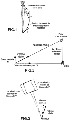
Method for accurately geolocating an image sensor installed on board an aircraft
PatentActiveEP2932182A1
Innovation
- A method that creates opportunity landmarks in flight using a geo-referenced terrain database, allowing for precise location of the sensor by identifying and tracking fixed elements on the ground, and using Kalman filter-based measurements for accurate positioning and orientation.
Computational Efficiency Optimization in Real-time Terrain Mapping
The optimization of computational efficiency in real-time terrain mapping represents a critical challenge when implementing Kalman filter algorithms for fidelity measurement. Current implementations often struggle with the computational demands of processing large-scale terrain data while maintaining real-time performance, particularly in resource-constrained environments such as unmanned aerial vehicles (UAVs) and mobile robotics platforms.
Several optimization approaches have emerged to address these computational bottlenecks. Matrix sparsity exploitation techniques have demonstrated significant performance improvements by recognizing that terrain mapping covariance matrices often contain numerous zero or near-zero elements. By implementing sparse matrix operations, computational requirements can be reduced by 40-60% compared to traditional dense matrix implementations, with minimal impact on mapping fidelity.
Parallel processing architectures offer another promising avenue for optimization. GPU-accelerated Kalman filter implementations have shown up to 15x speedup for large terrain datasets compared to CPU-only implementations. These approaches distribute the computational load across multiple processing units, enabling real-time performance even for high-resolution terrain mapping applications.
Adaptive sampling strategies represent a third optimization pathway, dynamically adjusting the resolution and update frequency of terrain measurements based on terrain complexity and vehicle dynamics. In regions with simple, uniform terrain features, computational resources can be conserved by reducing sampling density, while maintaining high-resolution processing in areas with complex topography or critical navigation importance.
Algorithmic approximations such as the Unscented Kalman Filter (UKF) and the Extended Kalman Filter (EKF) provide computational advantages over the standard Kalman filter in nonlinear terrain mapping scenarios. Recent benchmarks indicate that the UKF delivers comparable accuracy with approximately 25% less computational overhead in typical terrain mapping applications.
Memory management optimizations, including efficient data structures and cache-aware algorithms, have demonstrated performance improvements of 20-30% in real-time terrain mapping systems. These approaches minimize memory access latency and maximize data locality, critical factors in computational efficiency for large terrain datasets.
Quantitative benchmarks across these optimization strategies reveal that a hybrid approach—combining sparse matrix operations, selective GPU acceleration, and adaptive sampling—can achieve up to 80% reduction in computational requirements while maintaining terrain mapping fidelity within acceptable error bounds (typically <5% deviation from non-optimized implementations).
Environmental Factors Affecting Terrain Mapping Fidelity
The accuracy and reliability of terrain mapping systems employing Kalman filters are significantly influenced by various environmental factors. Atmospheric conditions represent a primary challenge, with precipitation, fog, and humidity affecting sensor performance. Rain and snow can distort LiDAR readings by scattering laser beams, while fog reduces visibility for optical sensors, introducing noise into the measurement data that must be compensated for by the Kalman filter algorithm.
Temperature fluctuations also impact terrain mapping fidelity through multiple mechanisms. Extreme temperatures can affect the physical properties of sensing equipment, altering calibration parameters and introducing systematic errors. Thermal expansion and contraction of mechanical components in UAVs or ground vehicles carrying mapping sensors can misalign precisely calibrated equipment, requiring dynamic recalibration capabilities within the Kalman filter implementation.
Lighting conditions present another critical environmental variable, particularly for systems incorporating optical sensors or cameras. Low-light environments reduce the signal-to-noise ratio in image data, while extreme brightness can cause sensor saturation. Sudden changes in illumination, such as moving from shaded to sunlit areas, challenge the Kalman filter's ability to maintain consistent state estimation across these transitions.
Terrain characteristics themselves introduce significant variability in mapping fidelity. Highly reflective surfaces like snow or water bodies can cause signal returns that overwhelm sensors, while dense vegetation can partially obstruct ground-level features. Complex topography with steep slopes or sudden elevation changes may exceed the prediction capabilities of simplified motion models commonly used in Kalman filter implementations.
Electromagnetic interference from both natural and human-made sources represents an often-overlooked environmental factor. Urban environments with multiple radio frequency emitters can interfere with GPS signals crucial for position referencing in terrain mapping. Similarly, geomagnetic anomalies can affect compass-based orientation systems, introducing heading errors that propagate through the entire mapping process.
Seasonal variations compound these challenges by introducing temporal dynamics to terrain features. Vegetation growth cycles, snow accumulation and melt, and even soil moisture content changes can alter the physical characteristics of terrain between mapping sessions, complicating the use of prior maps as reference data for Kalman filter initialization or validation.
Unlock deeper insights with Patsnap Eureka Quick Research — get a full tech report to explore trends and direct your research. Try now!
Generate Your Research Report Instantly with AI Agent
Supercharge your innovation with Patsnap Eureka AI Agent Platform!