

Three-dimensional resistivity tomography method and system
A tomography and resistivity technology, applied in radio wave measurement systems, material analysis by electromagnetic means, material analysis, etc., can solve the problem of indistinct boundary distinction between abnormal bodies, reduced detection accuracy, high data volume and high resistance abnormal response. and other problems, to achieve the effect of good intuition and visibility, improve detection accuracy and good visibility
Patent Information
- Authority / Receiving Office
- CN · China
- Patent Type
- Applications(China)
- Current Assignee / Owner
- Publication Date
- 2020-09-29
Smart Images
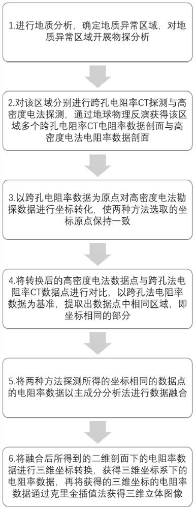
Figure 1 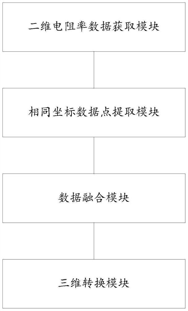
Figure 2 
Figure 3
Abstract
Description
technical field
[0001] The invention belongs to the field of geophysical prospecting, in particular to a three-dimensional resistivity tomography method and system. Background technique
[0002] The statements in this section merely provide background information related to the present invention and do not necessarily constitute prior art.
[0003] In today's geophysical prospecting field, there are various kinds of geophysical prospecting methods, such as geological radar, cross-hole method, well-ground method, high-density electrical method, transient electromagnetic method, etc., which are common detection methods in engineering sites . The above-mentioned geophysical prospecting methods often only have good detection results in certain ranges, and the methods themselves often have their own defects. For example, the reflection signal of high-frequency electromagnetic waves of geological radar carries the information of formation dielectric constant, which has strong re...
Examples
Embodiment 1
[0032] The idea of the three-dimensional resistivity tomography method in this embodiment is:
[0033] Use at least two exploration methods to explore areas containing geological anomalies, and obtain two-dimensional resistivity data on the corresponding detection plane; unify the coordinate system of the resistivity data points obtained by all exploration methods, and extract data points with the same coordinates; use the main The component analysis method performs data fusion on the resistivity data extracted at the same position; the resistivity data obtained after fusion is transformed into three-dimensional coordinates to form a three-dimensional model.
[0034] For example, the location of geological anomalies such as water-filled caves and water-conducting faults is roughly determined through analysis of geological data, and then geophysical exploration is carried out on the geological anomaly area, that is, cross-hole resistivity CT detection and high-density electric...
Embodiment 2
[0056] Such as figure 2 As shown, the three-dimensional resistivity tomography system of this embodiment includes:
[0057] (1) a two-dimensional resistivity data acquisition module, which is used to explore regions containing geological anomalies by using at least two exploration methods, and obtain two-dimensional resistivity data of corresponding detection planes;
[0058] Specifically, geological analysis is carried out to determine geological abnormal areas. Through engineering geological survey and drilling columnar information, analyze the distribution of geological and hydrological phenomena such as geological structure, topographic relief, overlying rock strata, karst cave development, water-conducting faults, etc. in the area, and also consult the geological data of the area to determine The approximate location of the geological anomaly, combined with the mineral composition, water content and other factors of the rock on site, determines the method of geophysical...
Embodiment 3
[0071] This embodiment provides a computer-readable storage medium, on which a computer program is stored. When the program is executed by a processor, the steps in the three-dimensional resistivity tomography method described in Embodiment 1 are implemented.
[0072] In this embodiment, the resistivity data obtained by at least two geophysical prospecting methods are compared to select resistivity data points with the same coordinates in the exploration area, and the data points obtained by at least two geophysical prospecting methods are fused based on the principal component analysis method, and finally Through the three-dimensional coordinate conversion, the formation of the three-dimensional model is realized, the detection accuracy is improved, and the detection results have good intuition and visibility.