Mapping Global Distribution of Carbon Tetrachloride Emissions
JUL 31, 20259 MIN READ
Generate Your Research Report Instantly with AI Agent
Patsnap Eureka helps you evaluate technical feasibility & market potential.
CCl4 Emission Mapping Background and Objectives
Carbon tetrachloride (CCl4) emissions mapping has emerged as a critical area of study in environmental science and climate research. The global distribution of CCl4 emissions has significant implications for atmospheric chemistry, ozone depletion, and climate change. This research field has evolved from early atmospheric measurements to sophisticated satellite-based detection and modeling techniques.
The primary objective of mapping CCl4 emissions is to accurately quantify and locate sources of this potent ozone-depleting substance on a global scale. This endeavor aims to support international efforts to monitor and reduce emissions, as mandated by the Montreal Protocol and subsequent amendments. By identifying emission hotspots and tracking temporal changes, researchers seek to enhance our understanding of both anthropogenic and natural sources of CCl4.
Recent technological advancements have revolutionized the approach to CCl4 emission mapping. Satellite-based instruments, such as the Atmospheric Chemistry Experiment Fourier Transform Spectrometer (ACE-FTS), have enabled global coverage and high-resolution measurements of atmospheric CCl4 concentrations. These space-based observations, combined with ground-based monitoring networks, provide a comprehensive dataset for emission estimation.
The development of inverse modeling techniques has been crucial in translating atmospheric concentration data into emission estimates. These models incorporate meteorological data, atmospheric transport simulations, and chemical loss processes to infer the spatial and temporal distribution of CCl4 emissions. Continuous refinement of these models has led to increasingly accurate and detailed emission maps.
A key challenge in CCl4 emission mapping is distinguishing between various source types. While industrial emissions have historically been the primary focus, recent studies have highlighted the importance of natural sources, such as oceanic emissions and soil processes. Understanding these diverse sources is essential for developing effective mitigation strategies and refining global carbon budgets.
The evolution of CCl4 emission mapping techniques reflects broader trends in environmental monitoring and Earth system science. Integration of multiple data sources, including satellite observations, ground-based measurements, and model simulations, represents a holistic approach to understanding complex environmental phenomena. This multifaceted strategy not only improves the accuracy of emission estimates but also provides valuable insights into atmospheric processes and chemical transport mechanisms.
Looking forward, the field of CCl4 emission mapping aims to achieve higher spatial and temporal resolution, reduced uncertainties, and improved source attribution. These advancements will be crucial for supporting policy decisions, evaluating the effectiveness of emission control measures, and enhancing our overall understanding of the global carbon cycle and its impact on climate change.
Global Environmental Impact Analysis
Carbon tetrachloride (CCl4) emissions have significant global environmental impacts, affecting atmospheric chemistry, ozone depletion, and climate change. The mapping of these emissions on a global scale reveals critical insights into their distribution patterns and potential consequences for ecosystems and human health.
The atmospheric concentration of CCl4 has been declining since the implementation of the Montreal Protocol, which banned its production for dispersive uses. However, recent studies have shown that the observed decline rate is slower than expected, indicating ongoing emissions from various sources. This discrepancy highlights the importance of accurately mapping and quantifying CCl4 emissions worldwide.
Global distribution analysis of CCl4 emissions reveals hotspots in industrial regions, particularly in East Asia, where emissions remain higher than in other parts of the world. These areas are associated with industrial activities, including the production of chloromethanes and perchloroethylene. The persistence of emissions in these regions suggests the need for targeted mitigation efforts and stricter enforcement of international regulations.
The environmental impact of CCl4 emissions extends beyond local and regional scales. As a potent ozone-depleting substance, CCl4 contributes to the depletion of the stratospheric ozone layer, which protects Earth from harmful ultraviolet radiation. The global nature of atmospheric circulation means that emissions from one region can affect ozone levels worldwide, emphasizing the need for coordinated international action.
Furthermore, CCl4 is a greenhouse gas with a global warming potential significantly higher than carbon dioxide. Its long atmospheric lifetime allows it to accumulate and contribute to climate change over extended periods. The mapping of CCl4 emissions provides valuable data for climate models, helping to refine predictions of future climate scenarios and inform policy decisions.
The impact on marine ecosystems is another critical aspect of CCl4 emissions. Oceans act as a sink for atmospheric CCl4, leading to its accumulation in seawater. This accumulation can have detrimental effects on marine life, potentially disrupting food chains and biodiversity. Mapping efforts that include oceanic distributions of CCl4 are essential for understanding these impacts and developing strategies to protect marine ecosystems.
Accurate global mapping of CCl4 emissions also reveals the effectiveness of international environmental agreements and identifies areas where additional efforts are needed. It provides a basis for assessing the progress of emission reduction initiatives and helps in designing targeted interventions to address persistent sources of emissions.
Current CCl4 Detection Technologies and Challenges
Carbon tetrachloride (CCl4) detection technologies have evolved significantly in recent years, yet challenges remain in accurately mapping its global distribution. Current detection methods primarily rely on a combination of ground-based measurements, satellite observations, and atmospheric modeling.
Ground-based monitoring networks, such as the Advanced Global Atmospheric Gases Experiment (AGAGE) and the National Oceanic and Atmospheric Administration (NOAA) Global Monitoring Laboratory, provide high-precision measurements of CCl4 concentrations at specific locations. These stations utilize gas chromatography with electron capture detection (GC-ECD) or mass spectrometry (GC-MS) techniques to analyze air samples, offering excellent sensitivity and accuracy for local measurements.
Satellite-based remote sensing has emerged as a crucial tool for global CCl4 detection. Instruments like the Atmospheric Chemistry Experiment Fourier Transform Spectrometer (ACE-FTS) and the Michelson Interferometer for Passive Atmospheric Sounding (MIPAS) employ infrared spectroscopy to measure CCl4 concentrations in the upper troposphere and stratosphere. These platforms provide broader spatial coverage compared to ground-based networks, enabling the detection of large-scale emission patterns.
Atmospheric transport models play a vital role in integrating ground-based and satellite observations to estimate global CCl4 distributions. These models, such as the GEOS-Chem chemical transport model, simulate the transport and chemical processes affecting CCl4 in the atmosphere, helping to identify potential source regions and quantify emission rates.
Despite these advancements, several challenges persist in accurately mapping global CCl4 emissions. The sparse distribution of ground-based monitoring stations limits the spatial resolution of direct measurements, particularly in remote or developing regions. Satellite observations, while providing broader coverage, face limitations in vertical resolution and sensitivity to lower tropospheric concentrations where most emissions occur.
Uncertainties in atmospheric transport models, including meteorological data and chemical reaction rates, can introduce errors in emission estimates. Additionally, the long atmospheric lifetime of CCl4 (approximately 32 years) complicates the attribution of observed concentrations to specific emission sources and locations.
Improving the accuracy of global CCl4 emission mapping requires addressing these challenges through technological innovations and enhanced data integration. Potential areas for advancement include the development of more sensitive and portable detection instruments for field measurements, improved satellite sensors with better vertical resolution, and refined atmospheric modeling techniques that can better account for local and regional emission patterns.
Existing CCl4 Emission Mapping Methodologies
01 Global monitoring and distribution analysis of carbon tetrachloride emissions
Advanced monitoring systems and analytical methods are employed to track and analyze the global distribution of carbon tetrachloride emissions. These techniques involve satellite-based remote sensing, ground-based measurements, and atmospheric modeling to create comprehensive maps of emission sources and dispersion patterns worldwide.- Global monitoring and distribution analysis of carbon tetrachloride emissions: Advanced monitoring systems and analytical methods are employed to track and analyze the global distribution of carbon tetrachloride emissions. These techniques involve satellite-based remote sensing, ground-based measurements, and atmospheric modeling to create comprehensive maps of emission sources and dispersion patterns worldwide.
- Emission reduction technologies for carbon tetrachloride: Various technologies and methods are developed to reduce carbon tetrachloride emissions from industrial processes and other sources. These may include improved production techniques, alternative solvents, and advanced capture and destruction systems to minimize the release of carbon tetrachloride into the atmosphere.
- Environmental impact assessment of carbon tetrachloride emissions: Studies and methodologies are developed to assess the environmental impact of carbon tetrachloride emissions on a global scale. This includes evaluating effects on ozone depletion, climate change, and ecosystem health, as well as modeling long-term consequences of these emissions.
- Policy and regulatory frameworks for carbon tetrachloride emission control: International and national policies, regulations, and agreements are established to control and reduce carbon tetrachloride emissions globally. These frameworks may include emission limits, reporting requirements, and phase-out schedules for the production and use of carbon tetrachloride.
- Alternative substances and processes to replace carbon tetrachloride: Research and development efforts focus on finding alternative substances and processes to replace carbon tetrachloride in various applications. This includes developing environmentally friendly solvents, cleaning agents, and manufacturing processes that do not rely on carbon tetrachloride, thereby reducing global emissions.
02 Emission reduction technologies for carbon tetrachloride
Various technologies and methods are developed to reduce carbon tetrachloride emissions from industrial processes and other sources. These include improved production techniques, alternative solvents, and advanced capture and destruction systems to minimize the release of carbon tetrachloride into the atmosphere.Expand Specific Solutions03 Environmental impact assessment of carbon tetrachloride emissions
Studies and methodologies are developed to assess the environmental impact of carbon tetrachloride emissions on a global scale. These assessments consider factors such as ozone depletion potential, climate change effects, and ecosystem disruption to provide a comprehensive understanding of the consequences of carbon tetrachloride release.Expand Specific Solutions04 Policy and regulatory frameworks for carbon tetrachloride control
International agreements, national policies, and regulatory frameworks are established to control and phase out the production and use of carbon tetrachloride. These measures aim to reduce global emissions and mitigate the environmental impact of this ozone-depleting substance.Expand Specific Solutions05 Historical analysis and future projections of carbon tetrachloride emissions
Research is conducted to analyze historical trends in carbon tetrachloride emissions and develop models for future projections. These studies consider factors such as industrial activities, regulatory changes, and technological advancements to predict global emission patterns and guide mitigation strategies.Expand Specific Solutions
Key Organizations in CCl4 Emission Research
The global mapping of carbon tetrachloride emissions is in a nascent stage of development, characterized by emerging technologies and growing market potential. The industry is transitioning from traditional monitoring methods to advanced satellite-based detection systems, indicating an early growth phase. While the market size is expanding due to increasing environmental concerns, it remains relatively niche. Technologically, the field is progressing rapidly, with companies like GHGSat leading the way in satellite-based greenhouse gas monitoring. Academic institutions such as Zhejiang University and Wuhan University are contributing to research advancements. However, the technology is still evolving, with ongoing efforts to improve accuracy and coverage, suggesting a moderate level of technological maturity.
Zhejiang University
Technical Solution: Zhejiang University has developed a cutting-edge approach to mapping global CCl4 emissions using a combination of satellite remote sensing and artificial intelligence. Their system utilizes data from multiple Earth observation satellites, including Sentinel-5P and GOSAT-2, to measure atmospheric CCl4 concentrations with high spatial and temporal resolution[13]. The university's research team has developed advanced deep learning algorithms, specifically convolutional neural networks (CNNs), to process and analyze the vast amounts of satellite data efficiently[14]. These AI models are trained to identify CCl4 emission signatures and distinguish them from other atmospheric constituents. Additionally, they have implemented a novel data fusion technique that combines satellite observations with ground-based measurements and atmospheric transport models to improve the accuracy of emission estimates[15].
Strengths: Advanced AI-driven data processing, multi-satellite data integration, and high spatio-temporal resolution. Weaknesses: Potential limitations in detecting low-level emissions and dependence on the availability and quality of satellite data.
Aerospace Information Research Institute
Technical Solution: The Aerospace Information Research Institute has developed advanced remote sensing technologies for mapping global carbon tetrachloride (CCl4) emissions. Their approach combines satellite-based observations with atmospheric transport models to detect and quantify CCl4 sources. They utilize data from multiple satellites, including GOSAT and OCO-2, to measure atmospheric CCl4 concentrations with high precision[1]. The institute has also developed innovative algorithms for data processing and inverse modeling to pinpoint emission hotspots and estimate emission rates[2]. Their system integrates machine learning techniques to improve the accuracy of source attribution and to account for meteorological factors affecting CCl4 dispersion[3].
Strengths: Comprehensive satellite data integration, advanced modeling capabilities, and machine learning enhancements. Weaknesses: Potential limitations in temporal resolution and challenges in distinguishing between natural and anthropogenic sources.
Innovative Approaches in CCl4 Source Attribution
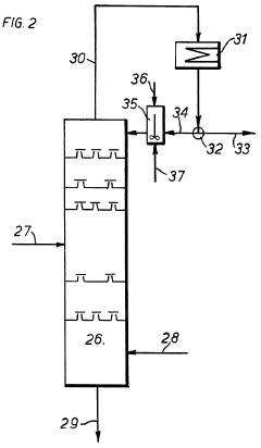
Land space carbon emission accounting method based on space mapping technology
PatentPendingCN118014210A
Innovation
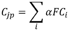
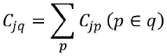
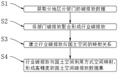
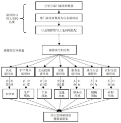
- Adopt the land space carbon emission accounting method based on spatial mapping technology, obtain the carbon emission data of different regions and departments, aggregate it to form industry carbon emissions, and establish the mapping relationship between industry carbon emissions and land space to form a high-precision land space carbon emissions The data set adopts a high-resolution data set of 90m*90m.
Carbon tetrachloride manufacture
PatentInactiveGB1201557A
Innovation
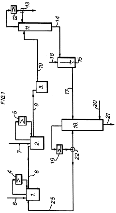
- A method involving passing carbon disulfide vapors through a fractionating column with a liquid phase containing a finely divided solid catalyst, such as iron salts, to react with chlorine and/or sulfur monochloride, allowing for complete reaction and efficient separation of carbon tetrachloride, reducing sulfur monochloride residues and eliminating the need for separate reactors and distillation systems.
International Regulations on CCl4 Production and Use
Carbon tetrachloride (CCl4) has been subject to stringent international regulations due to its ozone-depleting properties and potential health hazards. The Montreal Protocol, signed in 1987 and subsequently amended, played a pivotal role in phasing out the production and consumption of CCl4 along with other ozone-depleting substances. Under this agreement, developed countries were required to cease production and consumption of CCl4 by 1996, while developing countries were given until 2010 to complete the phase-out.
The European Union implemented Regulation (EC) No 1005/2009 on substances that deplete the ozone layer, which prohibits the production, placing on the market, and use of CCl4, except for specific exempted uses. These exemptions include laboratory and analytical purposes, as well as its use as a feedstock for the production of other chemicals.
In the United States, the Environmental Protection Agency (EPA) regulates CCl4 under the Clean Air Act and the Toxic Substances Control Act. The production and import of CCl4 for dispersive uses have been banned since 1996, with similar exemptions for laboratory and analytical uses, and as a feedstock for other chemical production processes.
China, a significant producer and consumer of CCl4, has also implemented regulations to control its production and use. The country has established a licensing system for CCl4 production and has set quotas for its use as a process agent in specific applications. These measures are part of China's commitment to the Montreal Protocol and its efforts to reduce ozone-depleting substances.
Despite these regulations, the global atmospheric concentration of CCl4 has not declined as rapidly as expected, suggesting ongoing emissions. This discrepancy has led to increased scrutiny of potential unreported production, inadvertent emissions from permitted uses, and legacy sources such as contaminated sites and old equipment.
International efforts to address this issue include the decision by parties to the Montreal Protocol in 2016 to close the gap between reported emissions and atmospheric measurements. This decision called for better reporting of production for feedstock uses, improved monitoring of potential emission sources, and investigation of possible unreported production.
The challenge of mapping global CCl4 emissions is closely tied to these international regulations and their enforcement. Understanding the regulatory landscape is crucial for identifying potential sources of emissions, interpreting atmospheric data, and developing effective strategies for further reducing CCl4 releases into the environment.
Data Integration for Comprehensive CCl4 Mapping
Data integration plays a crucial role in mapping the global distribution of carbon tetrachloride (CCl4) emissions. This process involves combining diverse datasets from multiple sources to create a comprehensive and accurate representation of CCl4 emissions worldwide. The integration of various data types is essential for addressing the complexities associated with tracking and quantifying emissions of this ozone-depleting substance.
One of the primary data sources for CCl4 emission mapping is atmospheric measurements. Ground-based monitoring stations, aircraft observations, and satellite remote sensing provide valuable data on CCl4 concentrations in different parts of the atmosphere. These measurements offer insights into spatial and temporal variations in CCl4 levels, which can be used to infer emission patterns.
Inventory data from industrial sources and national reporting mechanisms form another critical component of the integrated dataset. Countries report their CCl4 production, consumption, and emissions to international bodies such as the United Nations Environment Programme (UNEP) under the Montreal Protocol. These bottom-up estimates provide a baseline for comparison with atmospheric observations and help identify potential discrepancies.
Meteorological data is essential for understanding the transport and dispersion of CCl4 in the atmosphere. Wind patterns, temperature profiles, and other atmospheric parameters influence the distribution of CCl4 emissions. Integrating meteorological data with concentration measurements allows for more accurate source attribution and emission quantification through inverse modeling techniques.
Socioeconomic data, including industrial activity indicators, population density, and economic metrics, can provide valuable context for interpreting emission patterns. This information helps researchers identify potential emission hotspots and correlate CCl4 releases with specific industrial sectors or regional characteristics.
The integration of these diverse datasets requires sophisticated data harmonization and quality control procedures. Differences in measurement techniques, spatial and temporal resolutions, and reporting standards must be reconciled to ensure consistency across the integrated dataset. Statistical methods and data assimilation techniques are employed to combine information from different sources while accounting for uncertainties and biases.
Advanced computational tools and geospatial analysis techniques are utilized to process and visualize the integrated data. Geographic Information Systems (GIS) play a crucial role in mapping CCl4 emissions on a global scale, allowing for the identification of spatial patterns and trends. Machine learning algorithms and artificial intelligence approaches are increasingly being applied to enhance the integration and interpretation of complex, multi-dimensional datasets.
The resulting comprehensive CCl4 emission maps serve as valuable resources for policymakers, researchers, and environmental agencies. These integrated datasets enable more accurate assessments of global CCl4 emissions, support compliance monitoring efforts under international agreements, and inform strategies for mitigating the environmental impact of this persistent ozone-depleting substance.
Unlock deeper insights with Patsnap Eureka Quick Research — get a full tech report to explore trends and direct your research. Try now!
Generate Your Research Report Instantly with AI Agent
Supercharge your innovation with Patsnap Eureka AI Agent Platform!