

Use mmWave for Higher Resolution Spatial Mapping
SEP 22, 20259 MIN READ
Generate Your Research Report Instantly with AI Agent
PatSnap Eureka helps you evaluate technical feasibility & market potential.
mmWave Technology Background and Objectives
Millimeter wave (mmWave) technology operates in the frequency range of 30-300 GHz, with wavelengths between 1-10 millimeters. This technology has evolved significantly since its initial development in the mid-20th century for military and astronomical applications. The miniaturization of electronic components and advancements in semiconductor technology have transformed mmWave from a specialized research tool into a commercially viable technology with diverse applications.
The evolution of mmWave technology has accelerated dramatically in the past decade, driven by the increasing demand for high-bandwidth wireless communications, particularly with the global rollout of 5G networks. The technology's ability to utilize wider bandwidth channels enables data transmission rates that far exceed those of traditional wireless technologies operating at lower frequencies.
For spatial mapping applications, mmWave technology offers distinct advantages over conventional sensing technologies. The short wavelength of mmWave signals allows for higher resolution imaging and more precise object detection compared to lower frequency radar systems. Additionally, mmWave sensors can penetrate certain non-metallic materials, enabling them to detect objects behind obstacles, which is particularly valuable in complex environments.
The primary objective of utilizing mmWave for higher resolution spatial mapping is to develop systems capable of generating detailed three-dimensional representations of physical environments with centimeter-level accuracy. This includes the ability to detect, track, and classify objects within these environments, even under challenging conditions such as poor lighting, adverse weather, or the presence of visual obstructions.
Technical goals for mmWave spatial mapping include increasing the angular resolution of mmWave sensors, extending their effective range, improving their ability to distinguish between closely spaced objects, and enhancing their robustness against interference and noise. Additionally, there is a focus on developing more efficient signal processing algorithms that can extract meaningful spatial information from mmWave data in real-time.
Another critical objective is the integration of mmWave spatial mapping capabilities with other sensing modalities, such as optical cameras, LiDAR, and infrared sensors, to create multi-modal sensing systems that leverage the complementary strengths of different technologies. This fusion approach aims to overcome the limitations of individual sensing technologies and provide more comprehensive environmental awareness.
The long-term vision for mmWave spatial mapping technology extends beyond simple object detection to include advanced scene understanding, predictive capabilities, and autonomous decision-making. This evolution will require significant advancements in both hardware components and software algorithms, particularly in the areas of machine learning and artificial intelligence for interpreting complex mmWave data.
Market Analysis for High-Resolution Spatial Mapping
The global market for high-resolution spatial mapping technologies is experiencing robust growth, driven by increasing applications across multiple sectors. The millimeter wave (mmWave) technology segment is projected to grow significantly through 2030, with particularly strong adoption in autonomous vehicles, smart infrastructure, and industrial automation.
In the automotive sector, demand for high-precision spatial mapping solutions has accelerated dramatically as Level 3+ autonomous driving systems move toward commercial deployment. Vehicle manufacturers and technology providers are investing heavily in sensor fusion approaches that incorporate mmWave radar alongside traditional technologies like LiDAR and cameras, recognizing mmWave's superior performance in adverse weather conditions.
The smart city and infrastructure market represents another substantial opportunity, with municipal governments worldwide deploying advanced sensing networks for traffic management, pedestrian safety, and urban planning. These applications benefit from mmWave's ability to provide detailed spatial information while preserving privacy compared to camera-based alternatives.
Industrial automation presents a rapidly expanding market segment, with manufacturing facilities increasingly adopting high-resolution spatial mapping for robotic guidance, inventory management, and workplace safety applications. The manufacturing sector values mmWave technology for its reliability in dusty, poorly lit industrial environments where optical systems often struggle.
Consumer electronics represents an emerging but potentially massive market, with smartphone manufacturers beginning to incorporate mmWave sensors for enhanced AR/VR experiences, gesture recognition, and environmental awareness. This trend is expected to accelerate as miniaturization and cost reduction make the technology more accessible for consumer devices.
Geographically, North America currently leads in mmWave spatial mapping adoption, particularly in automotive and industrial applications. However, Asia-Pacific markets are showing the fastest growth rates, driven by rapid smart city deployments in China, Japan, and South Korea, along with strong manufacturing sector demand.
Key market challenges include cost considerations, with current high-resolution mmWave systems remaining relatively expensive compared to lower-resolution alternatives. Technical integration challenges also persist, particularly in fusing mmWave data with other sensing modalities to create comprehensive spatial awareness solutions.
Despite these challenges, the overall market trajectory remains strongly positive, with technology advancements steadily addressing current limitations. As mmWave components become more affordable and processing algorithms more sophisticated, the addressable market is expected to expand significantly beyond current applications.
Current mmWave Spatial Mapping Challenges
Despite significant advancements in millimeter-wave (mmWave) technology for spatial mapping applications, several critical challenges continue to impede the achievement of higher resolution capabilities. The inherent physical properties of mmWave signals present fundamental limitations that researchers and engineers must overcome to realize the full potential of this technology.
Signal attenuation remains one of the most significant obstacles in mmWave spatial mapping. These high-frequency waves (typically 30-300 GHz) experience substantial atmospheric absorption, particularly from oxygen molecules and water vapor. This attenuation increases dramatically during adverse weather conditions such as rain, fog, or snow, severely limiting operational reliability in outdoor environments.
Material penetration presents another major challenge. While mmWave signals can penetrate certain non-metallic materials, they experience significant reflection and absorption when encountering walls, furniture, and other common obstacles. This characteristic creates "shadow regions" in spatial maps where information is incomplete or entirely missing, compromising the overall mapping accuracy.
The narrow beamwidth of mmWave signals, while beneficial for directional precision, necessitates complex beam steering mechanisms to achieve comprehensive spatial coverage. Current phased array technologies struggle to balance the trade-off between scanning speed and resolution, often resulting in either slow mapping processes or reduced spatial detail.
Processing the massive data volumes generated by high-resolution mmWave sensors demands substantial computational resources. Real-time spatial mapping applications face particular difficulties in managing this data deluge while maintaining acceptable latency levels. Current signal processing algorithms often struggle to extract meaningful spatial information from noisy mmWave returns in complex environments.
Hardware limitations further constrain mmWave spatial mapping capabilities. The miniaturization of mmWave components while maintaining performance specifications remains challenging. Additionally, power consumption issues in mmWave systems limit their deployment in battery-operated devices, restricting mobility and operational duration.
Calibration and environmental adaptation represent ongoing challenges. mmWave systems require precise calibration to account for component variations and environmental factors. Current calibration methods often fail to adapt dynamically to changing conditions, resulting in degraded performance over time or across different operational scenarios.
Cost factors continue to inhibit widespread adoption of high-resolution mmWave spatial mapping. The specialized components, precise manufacturing requirements, and complex integration processes contribute to elevated system costs that limit deployment across many potential application domains.
Existing mmWave Spatial Resolution Solutions
01 High-resolution imaging and sensing with mmWave technology
Millimeter wave (mmWave) technology enables high-resolution imaging and sensing applications due to its short wavelength characteristics. These systems can achieve superior spatial resolution for object detection, tracking, and imaging compared to lower frequency technologies. The high bandwidth available in mmWave frequencies allows for fine range resolution and detailed imaging capabilities in various applications including security scanning, medical imaging, and industrial inspection.- mmWave radar resolution enhancement techniques: Various techniques are employed to enhance the resolution of mmWave radar systems, including advanced signal processing algorithms, beamforming optimization, and multiple-input multiple-output (MIMO) configurations. These approaches improve the ability to distinguish between closely spaced objects and provide more detailed imaging capabilities, which is crucial for applications requiring high precision detection and tracking.
- mmWave communication systems with high spatial resolution: mmWave technology enables communication systems with enhanced spatial resolution through the use of directional beamforming, massive antenna arrays, and high-frequency operation. These systems can achieve precise user targeting, reduced interference, and improved spectral efficiency. The high spatial resolution capabilities make mmWave particularly valuable for dense urban environments and applications requiring focused signal transmission.
- mmWave imaging and sensing resolution improvements: mmWave technology offers significant advantages for imaging and sensing applications due to its wavelength characteristics. Innovations in this area focus on improving resolution through advanced lens designs, computational imaging techniques, and sensor array configurations. These improvements enable applications such as security scanning, medical imaging, and industrial inspection with unprecedented detail and accuracy.
- mmWave resolution for autonomous vehicles and robotics: mmWave radar systems provide high-resolution sensing capabilities crucial for autonomous vehicles and robotics. These systems can detect and classify objects with precise distance, velocity, and angular measurements even in challenging environmental conditions. Advanced processing techniques and sensor fusion approaches further enhance the resolution capabilities, enabling reliable obstacle detection, navigation, and environmental mapping.
- Hardware innovations for improved mmWave resolution: Hardware advancements play a critical role in enhancing mmWave resolution capabilities. These innovations include specialized antenna designs, integrated circuit improvements, and novel materials that enable higher frequency operation with better signal quality. Custom chip architectures and advanced fabrication techniques allow for more compact, energy-efficient mmWave systems while simultaneously improving their resolution performance.
02 mmWave radar systems for enhanced resolution in automotive applications
mmWave radar systems provide high-resolution sensing capabilities for automotive applications, enabling advanced driver assistance systems (ADAS) and autonomous driving features. These systems can detect and track multiple objects simultaneously with precise distance, velocity, and angular measurements. The high resolution of mmWave radar allows vehicles to distinguish between closely spaced objects, detect vulnerable road users, and operate effectively in adverse weather conditions where optical sensors may fail.Expand Specific Solutions03 Beamforming techniques for improving mmWave resolution
Advanced beamforming techniques are employed in mmWave systems to enhance spatial resolution and overcome propagation challenges. These techniques include digital beamforming, hybrid beamforming, and adaptive beamforming algorithms that can dynamically adjust beam patterns. By focusing signal energy in specific directions, beamforming improves signal-to-noise ratio, extends range, and enhances the angular resolution of mmWave systems, enabling more precise target localization and tracking capabilities.Expand Specific Solutions04 Signal processing algorithms for mmWave resolution enhancement
Sophisticated signal processing algorithms are developed to enhance the resolution capabilities of mmWave systems. These include super-resolution algorithms, compressed sensing techniques, and advanced filtering methods that can extract more detailed information from mmWave signals. By applying these computational approaches, mmWave systems can achieve resolution beyond the theoretical limits imposed by antenna aperture size and signal bandwidth, enabling more detailed imaging and sensing applications.Expand Specific Solutions05 mmWave communication systems with high spatial resolution
mmWave technology enables communication systems with high spatial resolution, allowing for precise beam steering and spatial multiplexing. These capabilities support high-capacity wireless networks through efficient spectrum reuse and interference management. The narrow beams achievable with mmWave frequencies enable communication systems to serve multiple users simultaneously in dense environments, increasing network capacity while maintaining high data rates. This spatial resolution is particularly valuable in 5G and beyond 5G wireless networks.Expand Specific Solutions
Leading Companies in mmWave Spatial Mapping
The mmWave spatial mapping technology market is currently in a growth phase, with increasing adoption across various industries. The market is expanding rapidly due to the technology's ability to provide higher resolution spatial mapping for applications in autonomous vehicles, smart cities, and industrial automation. Major players like Intel, Huawei, and Samsung are leading technological innovation, with telecommunications companies such as Nokia, T-Mobile, and NTT Docomo driving infrastructure development. Research institutions including University of Electronic Science & Technology of China and Arizona State University are contributing to fundamental advancements. The technology is approaching maturity in certain applications, though challenges remain in standardization and cost reduction. Companies like Mitsubishi Electric and LG Electronics are focusing on specialized industrial applications, while Ericsson and NEC are developing integrated network solutions leveraging mmWave capabilities.
Huawei Technologies Co., Ltd.
Technical Solution: Huawei has developed advanced mmWave spatial mapping solutions that leverage their expertise in 5G technology. Their approach combines high-frequency (typically 60GHz+) mmWave radar systems with sophisticated signal processing algorithms to achieve centimeter-level accuracy in indoor and outdoor environments. Huawei's implementation utilizes MIMO (Multiple-Input Multiple-Output) antenna arrays with up to 256 elements to create highly directional beams that can be electronically steered for rapid environment scanning. Their proprietary algorithms perform real-time processing of reflected signals to generate detailed 3D point clouds, enabling applications ranging from autonomous navigation to augmented reality. The system employs frequency-modulated continuous wave (FMCW) radar techniques with bandwidths exceeding 2GHz to achieve resolution capabilities previously only possible with LiDAR systems but at potentially lower cost and with better performance in adverse weather conditions[1][3].
Strengths: Superior performance in adverse weather conditions compared to optical solutions; leverages existing 5G infrastructure expertise; high accuracy (centimeter-level) spatial mapping. Weaknesses: Higher power consumption than some competing technologies; complex signal processing requirements may limit deployment in very low-cost devices.
Samsung Electronics Co., Ltd.
Technical Solution: Samsung has pioneered mmWave spatial mapping technology integrated into their consumer electronics ecosystem. Their solution utilizes 60GHz and 77GHz frequency bands with custom-designed semiconductor components to enable high-resolution spatial awareness in smart devices. Samsung's approach combines multiple mmWave radar modules, each containing phased array antennas with up to 32 transmit and 32 receive elements, to achieve comprehensive spatial coverage. The system processes Doppler and time-of-flight measurements to generate detailed environmental maps with resolution down to 2-3cm. Samsung has implemented specialized machine learning algorithms that enhance the raw radar data by identifying and classifying objects within the mapped space, enabling context-aware applications. Their technology has been miniaturized sufficiently for integration into smartphones and wearable devices, while more robust versions are deployed in their smart home and automotive products[2][5]. The system operates at low power consumption levels through efficient duty cycling and adaptive scanning based on detected movement.
Strengths: Highly miniaturized form factor suitable for consumer electronics; integrated ecosystem approach connecting multiple devices; strong semiconductor manufacturing capabilities for cost optimization. Weaknesses: Proprietary ecosystem may limit interoperability with third-party solutions; consumer focus may result in less robust performance for industrial applications.
Key Patents and Innovations in mmWave Sensing
Tunable millimeter-wave MEMS phase-shifter
PatentInactiveUS20080272857A1
Innovation
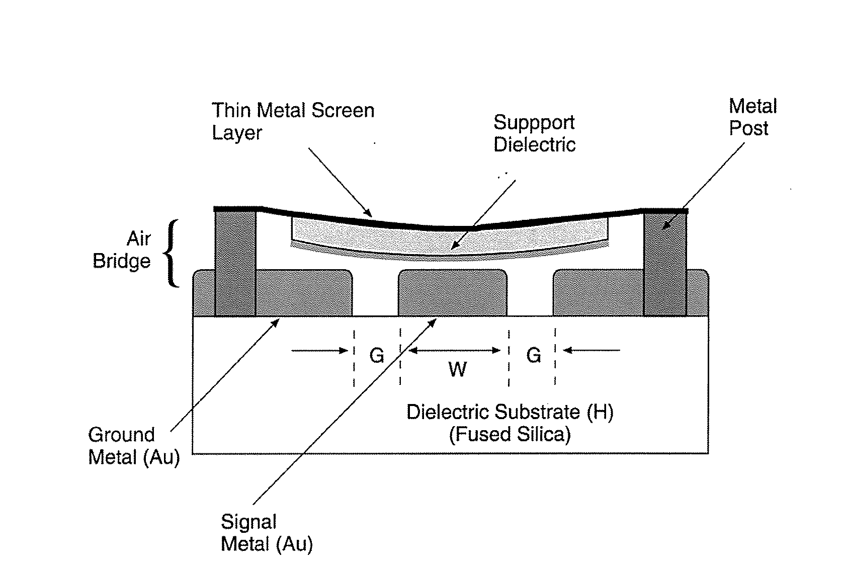
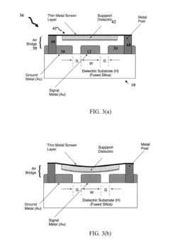
- A phase-shifter utilizing slow-wave propagation with a thin metal screen embedded in a dielectric layer, which spatially separates electric and magnetic fields, achieving low dispersion and low-loss, and incorporating an electrostatically actuated air bridge for tunability, allowing for compact size and wide frequency range operation.
Localization using millimeter wave beam attributes
PatentWO2021100791A1
Innovation
- The use of millimeter wave fingerprinting-based localization systems that leverage beam signal-to-noise ratio (SNR) and received signal strength indicator (RSSI) measurements, along with beam indices, to construct a location-dependent fingerprinting database, utilizing existing infrastructure without the need for dedicated hardware, and employing machine learning approaches for position classification and coordinate estimation.
Regulatory Framework for mmWave Applications
The regulatory landscape for millimeter wave (mmWave) technology presents a complex framework that varies significantly across global jurisdictions. In the United States, the Federal Communications Commission (FCC) has allocated specific frequency bands for mmWave applications, including 24 GHz, 28 GHz, 37 GHz, 39 GHz, and 47 GHz bands. These allocations have been instrumental in enabling commercial deployment of mmWave technology for spatial mapping applications while maintaining controlled interference with existing services.
The European Union, through the European Conference of Postal and Telecommunications Administrations (CEPT), has established harmonized technical conditions for mmWave usage, particularly focusing on the 26 GHz band (24.25-27.5 GHz) as a pioneer band for 5G services. These regulations incorporate specific power limits and operational parameters designed to protect adjacent scientific services, particularly Earth exploration satellite services.
In Asia, regulatory approaches vary considerably. Japan's Ministry of Internal Affairs and Communications (MIC) has allocated the 28 GHz band for mmWave applications with specific technical requirements for spatial mapping implementations. China's Ministry of Industry and Information Technology (MIIT) has designated portions of the 24.75-27.5 GHz and 37-43.5 GHz bands, with particular emphasis on industrial applications including high-resolution spatial mapping.
Power emission limitations represent a critical aspect of mmWave regulations globally. Most jurisdictions impose strict Equivalent Isotropically Radiated Power (EIRP) limits, typically ranging from 43 to 55 dBm depending on the specific application and deployment scenario. For spatial mapping applications, these limitations significantly impact the maximum operational range and resolution capabilities of mmWave systems.
Licensing requirements add another layer of complexity to the regulatory framework. While some countries have adopted license-exempt approaches for certain mmWave bands, others maintain strict licensing regimes. For high-resolution spatial mapping applications, specialized experimental or commercial licenses are often required, particularly when operating at higher power levels or in sensitive locations.
Privacy and data protection regulations increasingly intersect with mmWave spatial mapping applications. The high-resolution capabilities of these systems raise concerns regarding potential surveillance applications, leading to additional regulatory requirements in jurisdictions with strong privacy frameworks such as the EU's General Data Protection Regulation (GDPR) and California's Consumer Privacy Act (CCPA).
International harmonization efforts through the International Telecommunication Union (ITU) continue to evolve, with the World Radiocommunication Conference (WRC) periodically reviewing and updating global spectrum allocations for mmWave bands. These efforts aim to facilitate global interoperability while respecting regional priorities and protection requirements for incumbent services.
Integration with Complementary Sensing Technologies
The integration of mmWave technology with complementary sensing technologies represents a significant advancement in achieving higher resolution spatial mapping. By combining mmWave sensors with other sensing modalities, systems can overcome the inherent limitations of individual technologies while leveraging their respective strengths to create more comprehensive and accurate spatial representations.
LiDAR systems, when integrated with mmWave radar, create a powerful sensing combination. While LiDAR provides exceptional spatial resolution and point cloud density, it struggles in adverse weather conditions. Conversely, mmWave radar maintains performance in fog, rain, and snow. Recent implementations have demonstrated fusion algorithms that combine the high-resolution capabilities of LiDAR with the all-weather reliability of mmWave, resulting in robust spatial mapping solutions for autonomous vehicles and smart infrastructure.
Camera systems offer rich visual information that complements mmWave's depth and velocity measurements. Computer vision algorithms can extract semantic information from camera feeds, while mmWave provides accurate distance measurements and motion detection. This sensor fusion approach enables systems to not only map spaces but also understand the context and identify objects within them, creating semantically rich spatial representations.
Infrared sensors add another dimension to mmWave integration by providing thermal imaging capabilities. This combination proves particularly valuable in low-light environments and for human presence detection. The fusion of thermal signatures from infrared with the precise spatial positioning from mmWave enables advanced occupancy mapping and human activity recognition in smart buildings and security applications.
Ultrasonic sensors, operating at much lower frequencies than mmWave, excel at short-range detection and can be integrated to enhance near-field resolution. This multi-frequency approach addresses mmWave's challenges with minimum detection distance, creating a more complete spatial awareness system that functions effectively across various ranges.
IMU (Inertial Measurement Unit) integration with mmWave technology enables dynamic spatial mapping in motion. By compensating for the movement of the sensing platform through IMU data, mmWave-based spatial maps can maintain accuracy even when deployed on mobile robots or drones. This integration is crucial for applications requiring real-time mapping in dynamic environments.
The development of unified data processing frameworks represents the next frontier in multi-sensor integration. These frameworks synchronize data streams from different sensors, apply sensor-specific calibration, and implement fusion algorithms that can adaptively weight inputs based on environmental conditions and application requirements. Machine learning approaches, particularly deep neural networks, have shown promising results in automatically learning optimal fusion strategies for mmWave and complementary sensors.
Unlock deeper insights with PatSnap Eureka Quick Research — get a full tech report to explore trends and direct your research. Try now!
Generate Your Research Report Instantly with AI Agent
Supercharge your innovation with PatSnap Eureka AI Agent Platform!