Multi-format map tile generation method and system

A map tile and multi-format technology, applied to vector format still image data, geographic information database, still image data retrieval, etc., can solve problems such as not being able to meet production needs, and achieve the effect of improving scalability and high economic benefit ratio

Pending Publication Date: 2021-10-12
GEOVIS CO LTD
View PDF0 Cites 0 Cited by
  • Summary
  • Abstract
  • Description
  • Claims
  • Application Information

AI Technical Summary

Problems solved by technology

[0004] Under normal circumstances, it takes a few hours to generate map tiles (hereinafter referred to as cut maps) from an electronic map, and it takes a few days or even longer to generate them, which is far from meeting the actual production needs.

Method used


Image

  • Multi-format map tile generation method and system
  • Multi-format map tile generation method and system
  • Multi-format map tile generation method and system

Examples


Embodiment Construction

[0021] In order to make the purposes, technical solutions and advantages of the embodiments of the present application clearer, the technical solutions in the embodiments of the present application will be clearly and completely described below in conjunction with the drawings in the embodiments of the present application. Obviously, the described embodiments It is a part of the embodiments of this application, not all of them. Based on the embodiments in this application, all other embodiments obtained by persons of ordinary skill in the art without creative efforts fall within the protection scope of this application.

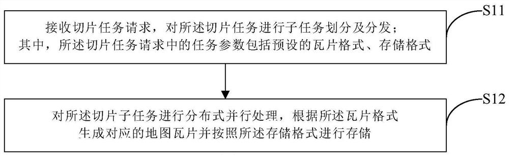
[0022] figure 1 It is a flowchart of an embodiment of the method for generating multi-format map tiles according to the present invention, such as figure 1 shown, including the following steps:

[0023] Step S11: Receive a slicing task request, divide and distribute the slicing task into subtasks; wherein, the task parameters in the slicing task request inc...


PUM


Abstract

The invention discloses a multi-format map tile generation method and system based on a distributed system, and the method comprises the steps: receiving a slicing task request, and carrying out the subtask division and distribution of a slicing task, wherein task parameters in the slicing task request comprise a preset tile format and a storage format; and performing distributed parallel processing on the slicing subtasks, generating corresponding map tiles according to the tile format, and storing the map tiles according to the storage format. By applying the scheme of the invention, the slicing task of the user can be self-adapted in various projections, various data formats, various output forms and the like, corresponding resources in the distributed system are reasonably called to quickly process data, and the method has extremely high benefits for improving the expansibility of the system and the economic benefit ratio of the system.

Description

【Technical field】 [0001] The invention relates to computer application technology, in particular to a method and system for generating multi-format map tiles. 【Background technique】 [0002] With the development of surveying and mapping technology, the volume of map data is getting larger and more frequent, and the present invention is mainly used to solve the problems of difficult dynamic update of map tiles and slow production speed. [0003] Map tiles are an optimization strategy to improve the user experience of map browsing. They are map tile files containing a series of scales and within a certain map range. The map tiles follow the pyramid structure, and each tile can be uniquely identified by level and row number. With the development of surveying and mapping technology, the volume of map data is getting larger and larger, and maps are updated more and more frequently. [0004] Under normal circumstances, it takes at least a few hours for an electronic map to gener...

Claims


Application Information

Patent Timeline
IPC IPC(8): G06F16/29G06F16/56
CPCG06F16/29G06F16/56
Inventor 巩志远
Owner GEOVIS CO LTD
Why Eureka
Try Eureka