
Deep neural network space spectrum classification method for high-spectral image
A deep neural network and hyperspectral image technology, which can be used in instruments, scene recognition, computing, etc., can solve the problems of information loss, lack of consideration of target pixel spatial information, and insufficient classification accuracy, and achieve the effect of good classification accuracy.
Patent Information
- Authority / Receiving Office
- CN · China
- Current Assignee / Owner
- Publication Date
- 2017-03-22
- Estimated Expiration
- Not applicable · inactive patent
Smart Images
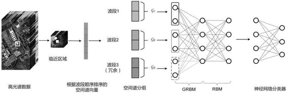
Figure 1 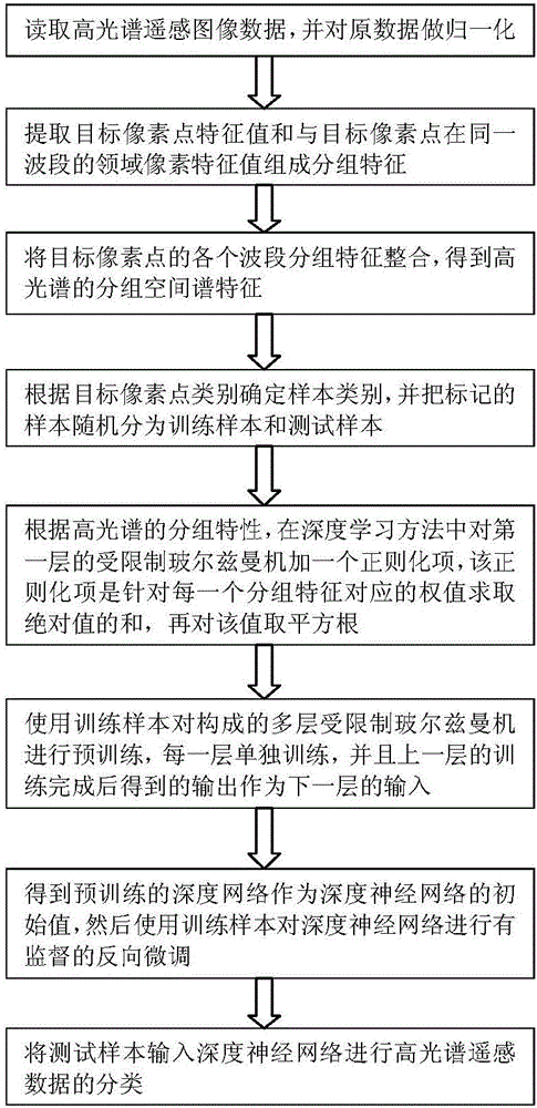
Figure 2 
Figure 3
Abstract
Description
technical field
[0001] The invention belongs to the technical field of deep learning and hyperspectral remote sensing image classification, and relates to a deep neural network spatial spectrum classification method for hyperspectral images. Background technique
[0002] With the continuous improvement of hyperspectral remote sensing image sensor technology, the spatial resolution and spectral resolution of hyperspectral remote sensing images have been greatly improved, whether on spaceborne or airborne, which makes the application of hyperspectral remote sensing images more and more widely. At the same time, with the improvement of spatial resolution and spectral resolution, it has also brought about a sharp increase in data dimensions, which can reach hundreds of dimensions. thousands of dimensions. This makes the previous algorithms that have good performance in low-dimensional space face great challenges in high-dimensional space.
[0003] At present, the main methods...
Examples
Embodiment Construction
[0028] The preferred embodiments of the present invention will be described in detail below with reference to the accompanying drawings.
[0029] figure 2 It is a schematic flowchart of the method of the present invention. As shown in the figure, the deep neural network spatial spectrum classification method for hyperspectral images provided by the present invention specifically includes the following steps:
[0030] Step 1: Read hyperspectral remote sensing image data and normalize the original data;
[0031] Step 2: Extract the feature value of the target pixel point and the feature value of the domain pixel in the same band as the target pixel point to form a grouping feature;
[0032] Step 3: Integrate the grouping features of each band of the target pixel point to obtain the grouping spatial spectral features of the hyperspectral;
[0033] Step 4: Determine the sample category according to the target pixel category, and randomly divide the marked samples into training ...