
Quantitative Evaluation Method of Seismic Exploration Observation System Based on Target Layer
An observation system and seismic exploration technology, applied in the direction of seismic signal processing, etc., can solve the problems of poor quality of the observation system, and achieve the effect of reliable principle, simple analysis, and easy analysis and comparison
Patent Information
- Authority / Receiving Office
- CN · China
- Patent Type
- Patents(China)
- Current Assignee / Owner
- Publication Date
- 2021-04-27
Smart Images
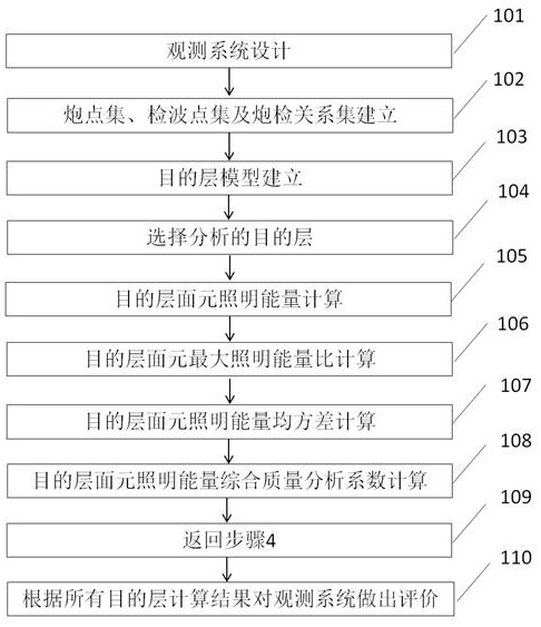
Figure 1 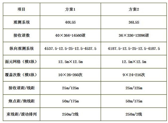
Figure 2 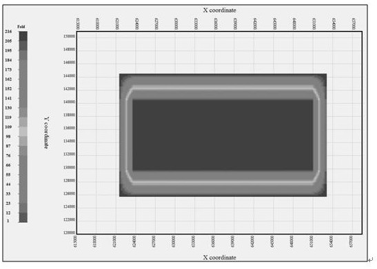
Figure 3
Abstract
Description
technical field
[0001] The invention relates to the field of oil and gas seismic exploration data acquisition and design, in particular to a quantitative evaluation method for a seismic exploration observation system based on a target layer. Background technique
[0002] Observation system evaluation work is mainly divided into two categories: the first category is based on the analysis method of common center point panel attribute. This method plays an important role in seismic data acquisition construction. It mainly includes coverage analysis, azimuth uniformity analysis, offset uniformity analysis and rose diagram uniformity analysis, etc., which have been proved to be practical and effective in the design of observation systems in many regions. This type of method exposes larger problems in areas with extremely complex surface and underground structures. The second type is the analysis method based on the surface elements of common reflection points. This type of met...
Examples
Embodiment 1
[0050] Example 1 is derived from a 3D seismic acquisition and observation system design project of Sinopec Shengli Oilfield. The work area is located in Dongying City, Shandong Province. The specific implementation methods are as follows:
[0051] (1) Two sets of observation systems were designed according to the geological tasks and technical indicators of the work area. The parameters of the observation systems are as follows: figure 2 ;
[0052] (2) According to the designed observation system parameters and the boundary of the full coverage times, the shot point set, the receiver point set and the shot detection relationship set are established;
[0053] (3) It is difficult to intuitively select a relatively more suitable observation system (such as image 3 with Figure 4 );
[0054] (3) Establish models of all target layers according to the horizon data interpreted by seismic data in the work area;
[0055] (4) Select the deepest target layer and set the lighting ca...
Embodiment 2
[0060] Example 2 is derived from a 3D seismic acquisition and observation system design project in the Xinjiang exploration area of Sinopec Shengli Oilfield. The work area is located in the Xinjiang Uygur Autonomous Region. The specific implementation methods are as follows:
[0061] (1) Two sets of observation systems were designed according to the geological tasks and technical indicators of the work area. The parameters of the observation systems are as follows: Figure 7 ;
[0062] (2) According to the designed observation system parameters and the boundary of the full coverage times, the shot point set, the receiver point set and the shot detection relationship set are established;
[0063] (3) It is difficult to intuitively select a relatively more suitable observation system (such as Figure 8 with Figure 9 );
[0064] (3) Establish models of all target layers according to the horizon data interpreted by seismic data in the work area;
[0065] (4) Select the deep...