Service robot autonomous navigation method based on raster maps

A service robot, grid map technology, applied in two-dimensional position/channel control and other directions, to achieve the effect of autonomous navigation, accuracy and efficiency improvement

CN103914068AInactive Publication Date: 2014-07-09PLA SECOND ARTILLERY ENGINEERING UNIVERSITY
6 Cites 138 Cited by

Patent Information

Authority / Receiving Office
CN · China
Patent Type
Applications(China)
Current Assignee / Owner
Publication Date
2014-07-09
Estimated Expiration
Not applicable · inactive patent

Smart Images

  • Figure 1
    Figure 1
  • Figure 2
    Figure 2
  • Figure 3
    Figure 3
Patent Text Reader

Abstract

The invention belongs to the technical field of robot navigation and relates to a service robot autonomous navigation method based on raster maps. According to the method, the information of the environment where a robot is located is acquired in real time through 2D laser radar, environment feature extraction is conducted, raster map establishment is conducted according to the acquired information by means of the SLAM technique, autonomous positioning is conducted on the robot in real time at the same time, path planning is conducted on the robot according to navigation task requirements on this basis, and then tracking control is conducted according to the planned path to enable the robot to accomplish the navigation task. Compared with the prior art, the method has the advantages that three key techniques in navigation are improved so that the method can meet actual requirements of service robot navigation better, and then the optimal feasible scheme is obtained; environment information is processed in real time to generate dynamic maps, and then autonomous navigation is achieved effectively, and navigation accuracy and efficiency are improved greatly.
Need to check novelty before this filing date? Find Prior Art

Description

technical field

[0001] The invention belongs to the technical field of robots and navigation, and relates to an autonomous navigation method for a service robot based on a grid map. Background technique

[0002] Autonomous mobile robot is an important branch in the field of robot research, and it has been widely used in many fields such as military, civilian, and scientific research. In recent years, with the development of computer, sensor and network technology, the focus of research has shifted from fixed manipulators and manipulators in structured environments to autonomous mobile robots in unstructured unknown environments. The traditional methods of modeling the space environment of the manipulator and teaching the movement can no longer meet the new tasks faced by autonomous mobile robots. Autonomous navigation technology is the core of mobile robot research and the key technology to realize autonomous movement, mainly including autonomous positioning, path planning,...

Examples

Embodiment Construction

[0039] The present invention will be described in detail below with reference to the accompanying drawings. It should be noted that the described embodiments are only intended to facilitate the understanding of the present invention, and do not limit it in any way.

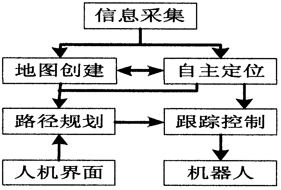
[0040] figure 1 It is a flow chart illustrating the main steps of implementing the autonomous navigation method for a service robot based on a grid map according to the present invention. refer to figure 1 , the main process of this method is:

[0041] Step 1: Control the robot to move in the known experimental environment, and create a map according to the environmental information collected by 2D lidar and extracted by features, and obtain the global environmental grid map;

[0042] Step 2: Execute the autonomous positioning module, determine the pose of the robot in the global coordinate system, and set the target point according to the navigation task requirements;

[0043] Step 3: In the global environment...