Method of collecting information for a geographic database for use with a navigation system

a geographic database and information collection technology, applied in the field of navigation system operation, can solve the problems of end users being confused as to their orientation and where to turn

Active Publication Date: 2012-10-30
HERE GLOBAL BV
View PDF29 Cites 2 Cited by
  • Summary
  • Abstract
  • Description
  • Claims
  • Application Information

AI Technical Summary

Problems solved by technology

Some end users may get confused as to their orientation and where to turn.

Method used


Image

  • Method of collecting information for a geographic database for use with a navigation system
  • Method of collecting information for a geographic database for use with a navigation system
  • Method of collecting information for a geographic database for use with a navigation system

Examples


Embodiment Construction

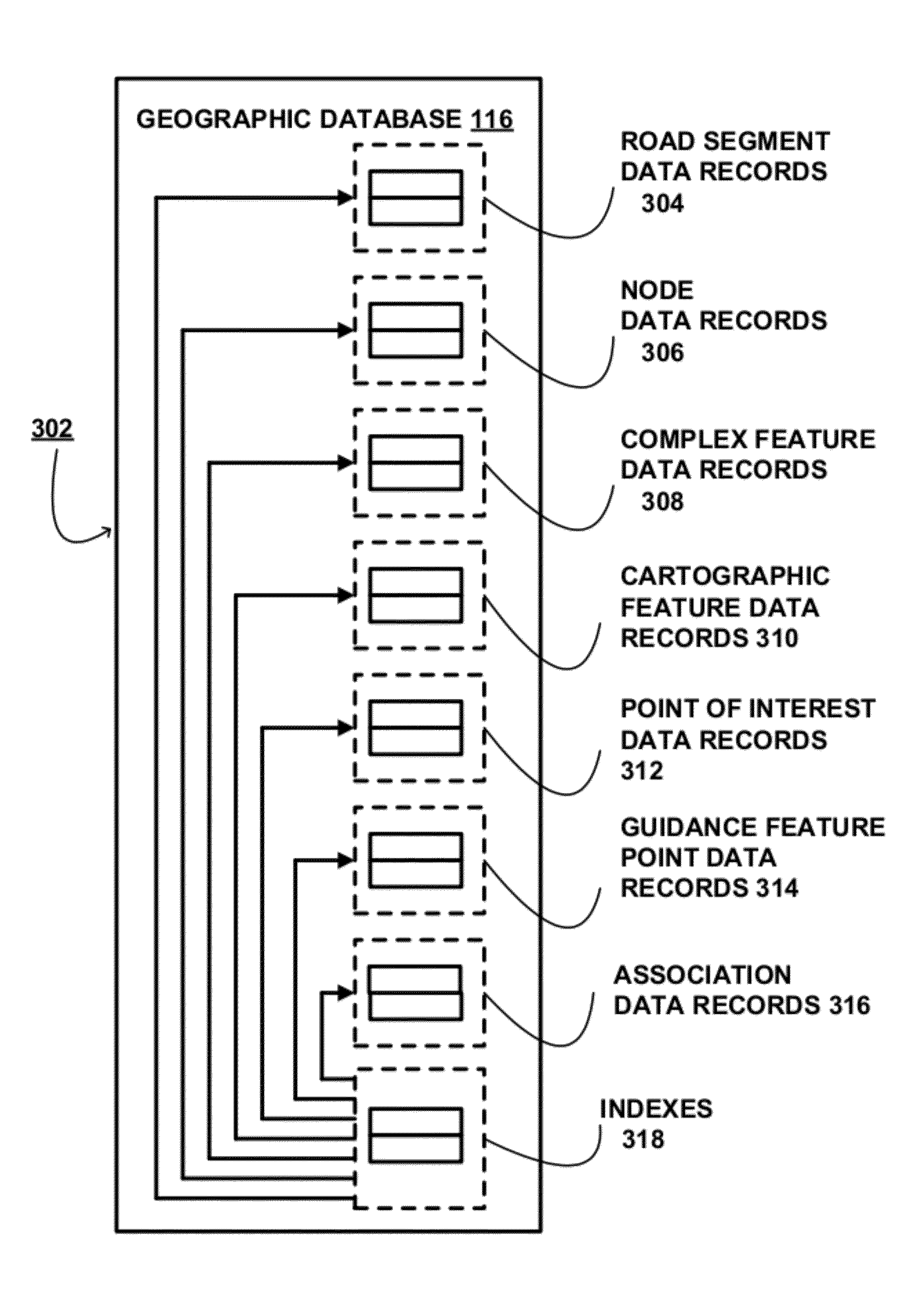
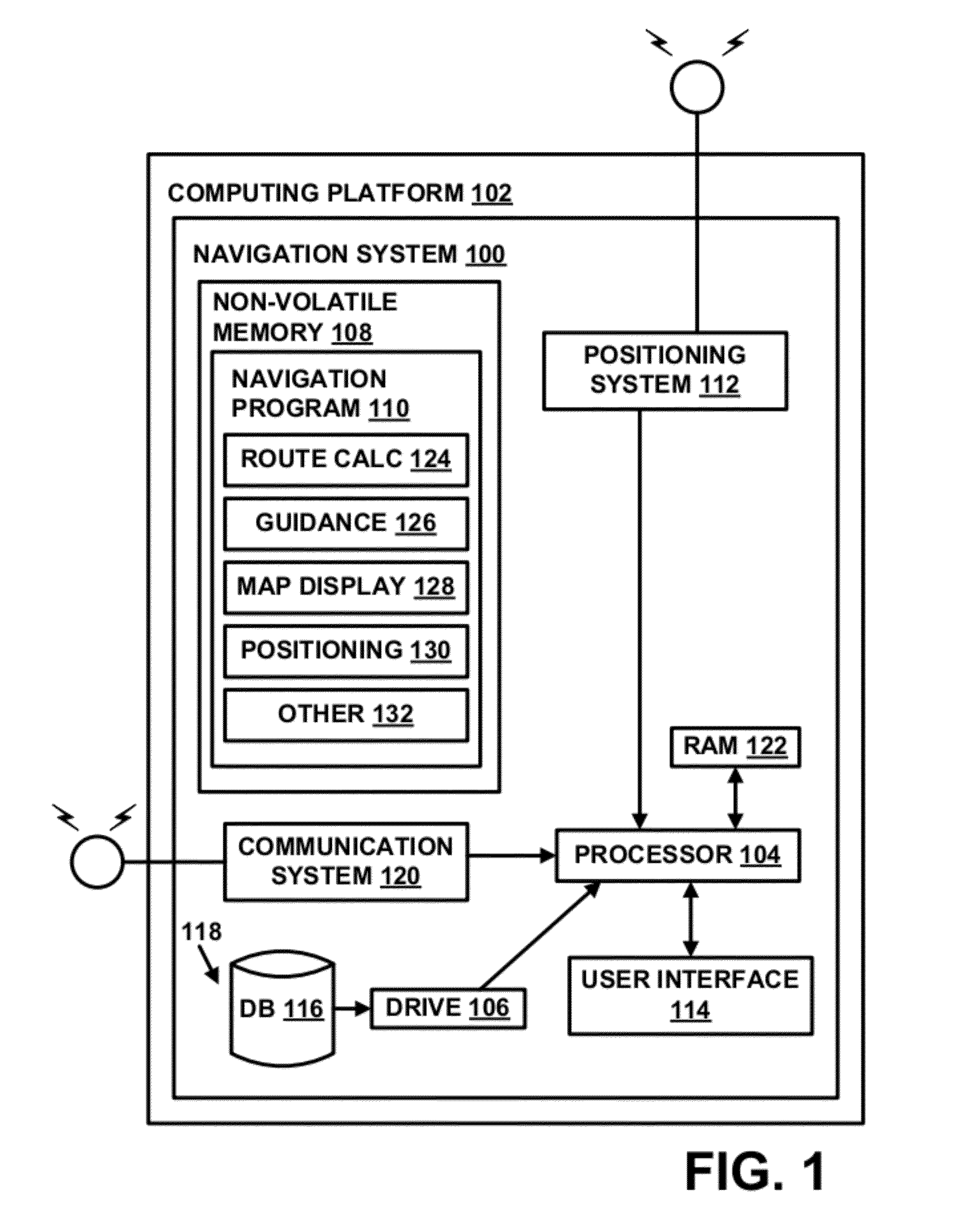
[0020]I. Navigation System

[0021]FIG. 1 is a block diagram of a navigation system 100 associated with a computing platform 102, such as an in-vehicle navigation device, a personal navigation device, a mobile computer, mobile telephone, personal digital assistant (PDA), personal computer, or any other computer, according to an exemplary embodiment. The navigation system 100 is a combination of hardware and software components. In one embodiment, the navigation system 100 includes a processor 104, a drive 106 connected to the processor 104, and a non-volatile memory storage device 108 for storing navigation application software programs 110 and possibly other information.

[0022]The navigation system 100 also includes a positioning system 112. The positioning system 112 may utilize GPS-type technology, a dead reckoning-type system, or combinations of these or other systems, all of which are known in the art. The positioning system 112 may include suitable sensing devices that measure the...


PUM


Abstract

A method of collecting data for a geographic database for use with a navigation system is disclosed. A feature visible from a road segment is identified. A guidance feature point object is defined at a location at the road segment where the identified feature is most visibly prominent. Additionally, an importance rating and a preferred name for the identified feature are determined. Data representing the guidance feature point object, importance rating and the preferred name are stored in the geographic database on a computer readable medium.

Description

REFERENCE TO RELATED APPLICATIONS[0001]The present application is related to the co-pending application entitled “METHOD OF OPERATING A NAVIGATION SYSTEM TO PROVIDE ROUTE GUIDANCE” filed on the same date herewith, Ser. No. 12 / 549,604, the entire disclosure of which is incorporated by reference herein. The present application is related to the co-pending application entitled “METHOD OF OPERATING A NAVIGATION SYSTEM TO PROVIDE ROUTE GUIDANCE” filed on the same date herewith, Ser. No. 12 / 549,624, the entire disclosure of which is incorporated by reference herein.BACKGROUND OF THE INVENTION[0002]The present invention relates to a method and system for operating a navigation system, and more particularly to a method and system for providing route guidance using contextual elements along a calculated route from an origin location to a destination location.[0003]Navigation systems are available that provide end users with various navigation-related functions and features. For example, some...

Claims


Application Information

Patent Timeline
Patent Type & Authority Patents(United States)
IPC IPC(8): G06F17/00G06F7/00
CPCG01C21/32G01C21/3644G06F17/30241G06F16/29
Inventor ROSSIO, SARA B.WIKLUND, CHRISTOPHER S.DANNENBRING, AARON J.VAN ROOIJ, ERIVSRIVASTAVA, DEEPESH
Owner HERE GLOBAL BV
Why Eureka
Try Eureka