Isoline iteration gravity matching algorithm based on mahalanobis distance

A Mahalanobis distance and gravity matching technology, which is applied in the fields of navigation, guidance and control, can solve the problems of poor matching effect, affecting navigation accuracy, and no comprehensive consideration, so as to reduce the false matching rate, improve matching accuracy, and improve system navigation. The effect of positioning accuracy

Pending Publication Date: 2021-11-09
BEIJING INSTITUTE OF TECHNOLOGYGY
View PDF0 Cites 1 Cited by
  • Summary
  • Abstract
  • Description
  • Claims
  • Application Information

AI Technical Summary

Problems solved by technology

The traditional ICCP algorithm uses the Euclidean distance as the objective function, and does not comprehensively consider the influence of the gravity field background image error and the gravity real-time measureme

Method used


Image

  • Isoline iteration gravity matching algorithm based on mahalanobis distance
  • Isoline iteration gravity matching algorithm based on mahalanobis distance
  • Isoline iteration gravity matching algorithm based on mahalanobis distance

Examples


Embodiment Construction

[0035] The present invention will be described in detail below with reference to the accompanying drawings and examples.

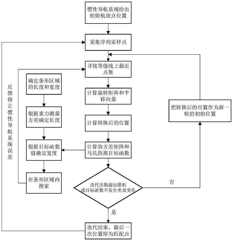
[0036] The invention provides a contour iterative gravity matching algorithm based on the Mahalanobis distance, which effectively improves the precision of the inertial navigation system by using the Mahalanobis distance instead of the Euclidean distance in the traditional ICCP algorithm as an iterative objective function.

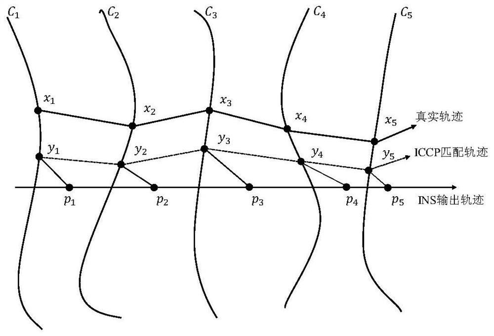
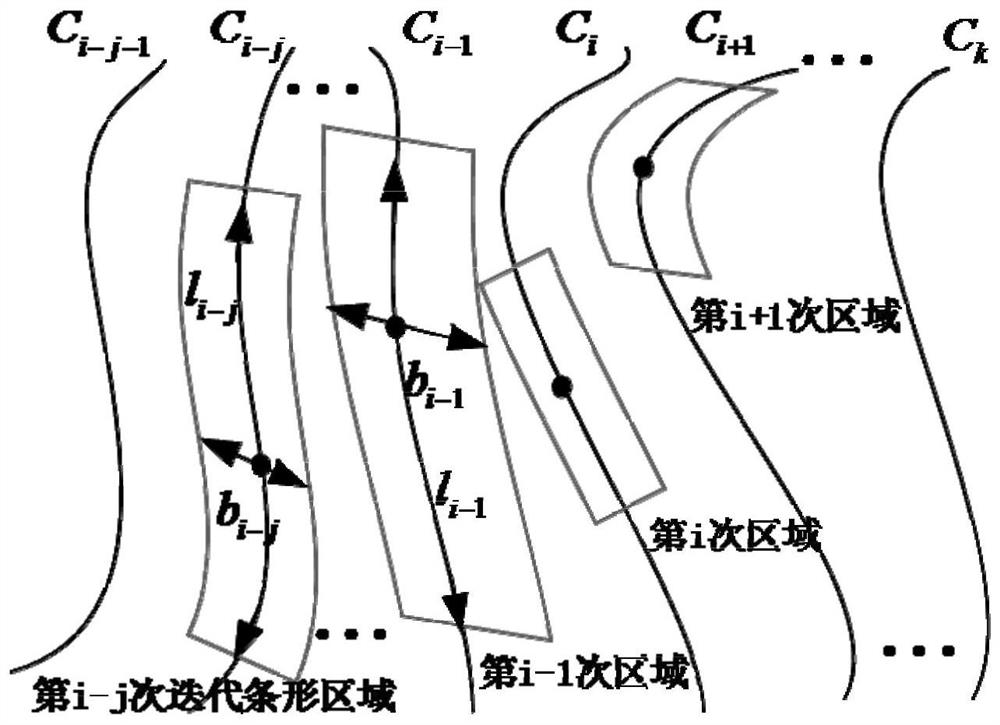
[0037] The principle of the contour iterative gravity matching algorithm of the present invention is: in the background map of the gravity field known in advance, according to the actual measurement information of the gravimeter, the gravity anomaly value is extracted, and the gravity anomaly contour map of the navigation area is obtained, and then proposed Hypothesis: The real track point of the vehicle in the water must fall on a certain contour line, and its value corresponds to the gravity anomaly measurement value. On the gravity ...


PUM


Abstract

The invention discloses an isoline iteration gravity matching algorithm based on mahalanobis distance. The real-time error of gravity measurement is considered, the navigation error covariance matrix is utilized to represent the precision of the gravity anomaly background image and the gravity real-time measurement precision, the Mahalanobis distance is adopted as an iteration objective function, the covariance matrix is introduced to represent the density degree of the point sets, the same point set has high similarity, more correct matching point pairs are reserved, the matching precision of the algorithm is improved, and the navigation and positioning precision of the system is further improved. Meanwhile, a strip search area range improvement strategy is provided based on a measurement error and an objective function value, so that the search area is reduced along with the increase of the number of iterations, the convergence of the ICCP algorithm is embodied, the calculated amount of the algorithm when the nearest point on the isoline is searched is gradually reduced, and the possibility of searching the global optimal point is increased.

Description

technical field [0001] The invention relates to the technical field of navigation, guidance and control, in particular to a Mahalanobis distance-based contour iterative gravity matching algorithm. Background technique [0002] Since the inertial navigation system can provide navigation and positioning information such as position, speed, and attitude for the carrier in real time, it is widely used in various carriers on land, sea, air and space. However, during the long-term continuous work of large submersibles underwater, if the inertial navigation system is used only for navigation, the error will accumulate over time, which will seriously affect the accuracy of navigation and positioning. Therefore, it is necessary to use other information from the outside world to assist navigation. The marine gravity field has characteristic stability and position correlation, which lays the foundation for assisting long-duration inertial navigation systems. Gravity matching is the c...

Claims


Application Information

Patent Timeline
IPC IPC(8): G01C21/16G01C21/20G06F17/16
CPCG01C21/165G01C21/20G06F17/16
Inventor 邓志红王宇赵生武王博石雷张文喆
Owner BEIJING INSTITUTE OF TECHNOLOGYGY
Why Eureka
Try Eureka