Locality indexes and method for indexing localities

Inactive Publication Date: 2007-11-29
TELE ATLAS NORTH AMERICA
View PDF4 Cites 122 Cited by
  • Summary
  • Abstract
  • Description
  • Claims
  • Application Information

AI Technical Summary

Benefits of technology

[0013] Locality names from various locality name sources are associated with the geographic features for each geographic feature in a geographic database. Context-sensitive tokenizing, normalizing, optimizing and matching of locality names allows for eliminating and merging of duplicate and variant locality names, while preserving meaningfully different names. Duplicate locality names are eliminated, if and only if they represent the same locality, to reduce confusion for a user who must otherwise choose between a list of identical or similar names. Geographic database entries for localit

Problems solved by technology

Currently, either geographic databases are not supplied with locality indexes or have locality indexes that are of limited functionality when searching for geographic features in localities.
This is confusing to the user who must choose between identical or nearly identical names displayed to the user's system or device screen.
A further problem exists in the list of locality names if the user is unable to differentiate between actual duplicate localities and disjoint localities having the same or slightly variant names.
The problem of duplicate locality names from multiple locality name sources is exacerbated in some navigation devices that have limited memory.
For geographic databases having locality index

Method used


Image

  • Locality indexes and method for indexing localities
  • Locality indexes and method for indexing localities
  • Locality indexes and method for indexing localities

Examples


Embodiment Construction

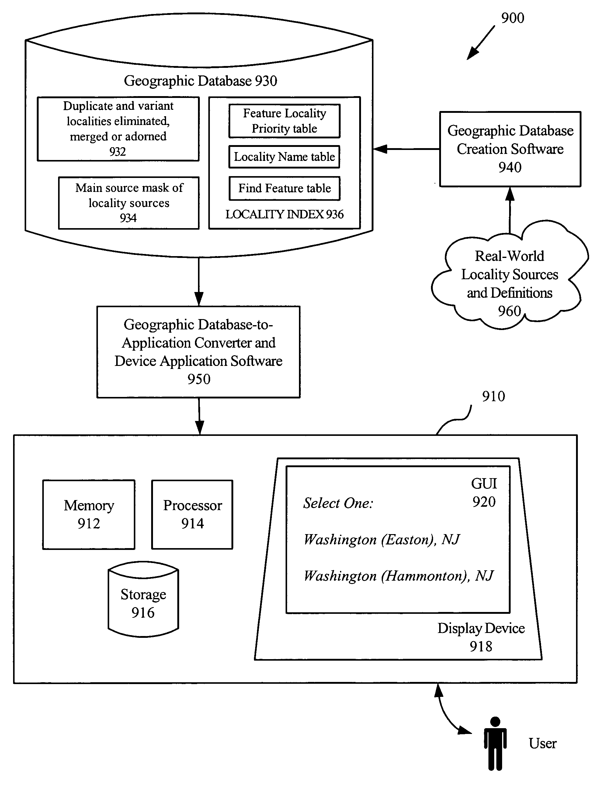
[0032] In order to create a better locality index, a thorough list of locality names must first be created by gathering names from a variety of locality name sources, administrative, postal and colloquial locality name sources, among others. Using locality names from any number and type of sources allows for a universal schema for international data. Without this feature only a fixed number of sources may be used, such as postal or administrative name sources, potentially missing important names and constraining the types of sources that may be used in different countries.

[0033] Although the language used in this description is specific to the United States, in embodiments, the same principles can be applied internationally with only nominal adjustments. Examples of foreign locality name source equivalents include the Ordnance Survey and Royal Mail in the United Kingdom, and Stats Can and Canada Post in Canada.

[0034] In embodiments, for a given set of locality name sources, a list...


PUM


Abstract

Locality indexes are presented for use with electronic maps and databases. Each geographic feature in a geographic database is associated with locality names from various locality name sources. Context-sensitive tokenizing, normalizing, optimizing and matching of locality names eliminate duplicate and variant locality names, while preserving meaningfully different names. A locality names table includes the parsed representation of each locality name and other associated information, and a primary token for indexing is identified. A main source mask is created by allocating a bit for each locality name source used in the method. A separate source mask is stored for each geographic feature associated with a locality, a bit set for each source in which the locality can be found. Locality names associated with each geographic feature are indexed in a table of geographic features in order of prevalence for use in a given application.

Description

FIELD OF THE INVENTION [0001] The present invention relates to indexes of localities for geographic databases, and more particularly, to data structures in geographic databases used for indexing locality names and associated geographic features contained in the localities. BACKGROUND OF THE INVENTION [0002] In recent years, consumers have been provided with a variety of devices and systems to enable them to locate specific street addresses on a digital map. These devices and systems are in the form of in-vehicle navigation systems that enable drivers to navigate over streets and roads, portable hand-held devices such as personal digital assistants (“PDAs”), personal navigation devices and cell phones that can do the same, and Internet applications in which users can generate maps showing desired locations. The common aspect in all of these and other types of devices and systems is a geographic database of geographic features and software to access and manipulate the geographic datab...

Claims


Application Information

Patent Timeline
IPC IPC(8): G06F7/00G06F17/00
CPCG06F17/30241G06F16/29G06F16/24557G06F16/2255
Inventor GEILICH, MICHAEL
Owner TELE ATLAS NORTH AMERICA
Why Eureka
Try Eureka