Integration of positional data and overhead images for lane identification

a positional data and overhead image technology, applied in the field of mapping, imagery, and vehicle navigation services, can solve the problems of large blind spots, inaccurate estimations of existing mapping services, and large errors even a few centimeters of errors

Inactive Publication Date: 2017-04-27
NOKIA TECHNOLOGLES OY
View PDF2 Cites 54 Cited by
  • Summary
  • Abstract
  • Description
  • Claims
  • Application Information

AI Technical Summary

Problems solved by technology

Existing mapping services may use inaccurate estimates based on sets of data which are not designed to offer the precise measurements required.
For generalized routing, this may be adequate to offer a rough estimate of a distance from point A to point B. However, for assisted driving, errors of even a few centimeters may be hazardous.
When used alone though, on-board sensor systems may exhibit large blind spots and may be unable to predict events or maneuvers even a short distance away.
A sensor may miss lane markings that are not clearly visible to the vehicle, lack the ability to identify if a car is in lane three or four of an eight lane highway, or not identify the matrix environment of an intersection with no lane markings.
Additionally, these sensors and algorithms are generally used for real time navigation and only estimate lanes of roads at a certain ...

Method used


Image

  • Integration of positional data and overhead images for lane identification
  • Integration of positional data and overhead images for lane identification
  • Integration of positional data and overhead images for lane identification

Examples


Embodiment Construction

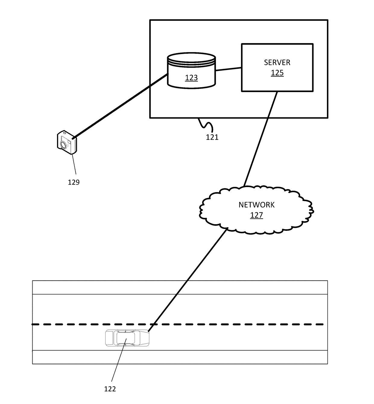
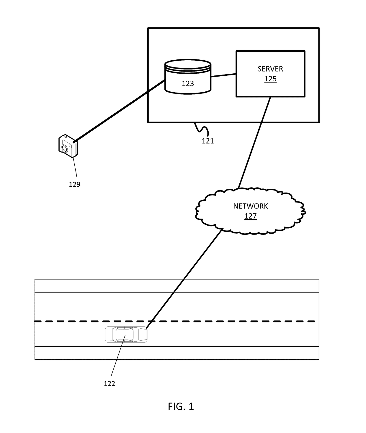
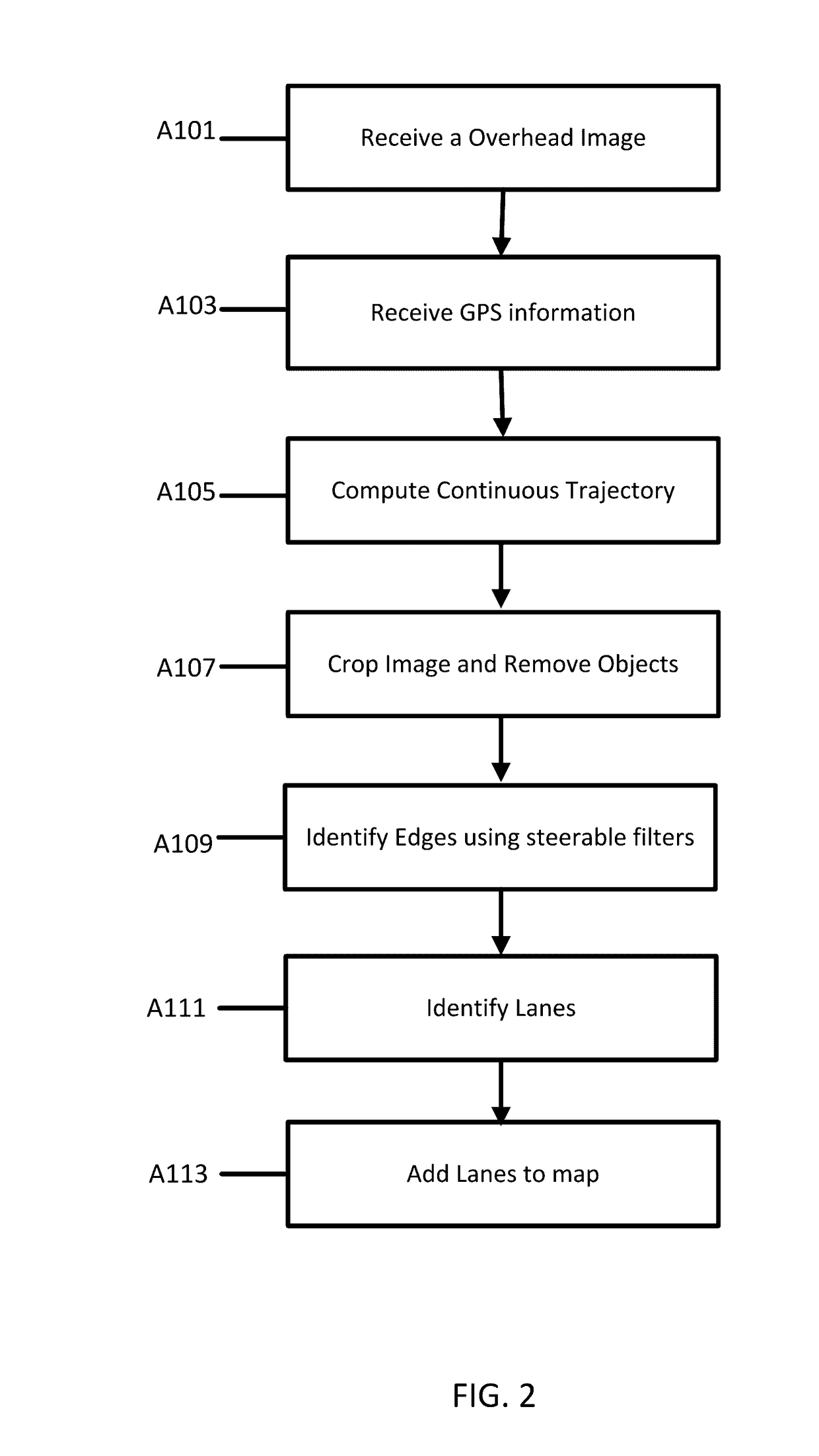
[0020]The following embodiments relate to using overhead images and global positioning system (GPS) information to efficiently locate and identify lanes in a roadway image. A trajectory of a vehicle derived from GPS is used to estimate road regions in the overhead image. Objects such as trees and vehicles are removed from the overhead image. Edge features are identified using a steerable filter (using the trajectory). Lanes are detected by finding the maximum of the sum of filter responses. Portions of the lanes which are covered or hidden in the overhead images are then estimated from the detected lanes.

[0021]Existing algorithms generally use satellite images for centerline estimation. Embodiments herein integrate GPS information and overhead images together to greatly improve the efficiency and accuracy of lane identification. Other systems use information captured from sensors onboard vehicles. Sensors may offer alerts when a car is moving too close to another object, but additio...


PUM


Abstract

A method and apparatus for lane detection using overhead images and positional data. A server receives positional data from a vehicle and computes a continuous trajectory. The server receives an overhead image of a road section. The server crops and processes the overhead image to remove unwanted portions. The server identifies edge features using the continuous trajectory and steerable filters. The server identifies lanes in the overhead image using a maximization algorithm, the edge filters, and the continuous trajectory.

Description

FIELD[0001]The following disclosure relates to mapping, imagery, and vehicle navigation services.BACKGROUND[0002]Modern vehicles require accurate navigational systems. A vehicle may eliminate many dangerous unknowns by identifying exactly where the vehicle is on the road in real time, along with its immediate surroundings. A high definition (HD) map is a crucial component of assisted or automatic driving technology. Vehicles may include many sensors, but a HD map may be the most important tool vehicles use.[0003]An HD map is needed not only to allow a vehicle to precisely position itself laterally and longitudinally, but to enable the car to maneuver correctly. While sensors in vehicles may detect objects out around 100 meters, a car traveling at 80 miles per hour only has a sensing horizon of 3 seconds. Vehicles need highly accurate and up to date maps to extend sensor range and “peek” around the corner.[0004]Existing mapping services may use inaccurate estimates based on sets of d...

Claims


Application Information

Patent Timeline
IPC IPC(8): G06K9/00G06T7/20G06K9/46G06V10/25G06V10/44G06V10/56
CPCG06K9/00651G06K9/4638G06T7/204G06T2210/22G06T2207/20024G06T2207/30241G06T2207/10032G06T19/003G01C21/26G06V20/182G06V10/25G06V10/44G06V10/56G01C21/3815G01C21/3848G01C21/3852G01C21/3819G06T7/248
Inventor CHEN, XINHUANG, XINYU
Owner NOKIA TECHNOLOGLES OY
Why Eureka
Try Eureka