Geographic coding method, position inquiring system and position inquiring method

A geocoding and geographic location technology, applied in geographic information databases, digital data processing, special data processing applications, etc., can solve problems such as increasing the complexity of approximate queries, and achieve massive location matching approximate queries and compact space for time. Effect

Inactive Publication Date: 2014-05-21
刘龙
View PDF6 Cites 54 Cited by
  • Summary
  • Abstract
  • Description
  • Claims
  • Application Information

AI Technical Summary

Problems solved by technology

The current solution is to calculate all 8 subgrids around the current subgrid, but this increases the complexity of the approximate query

Method used


Image

  • Geographic coding method, position inquiring system and position inquiring method
  • Geographic coding method, position inquiring system and position inquiring method
  • Geographic coding method, position inquiring system and position inquiring method

Examples


Embodiment Construction

[0057] In order to make the objectives, technical solutions and advantages of the present invention clearer, the present invention will be described in detail below with reference to the accompanying drawings and specific embodiments.

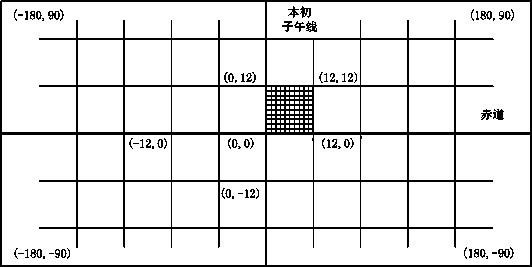
[0058] figure 1 is a schematic flowchart of the geocoding method according to the present invention. like figure 1 Shown, according to geocoding method of the present invention, comprises the following steps:

[0059] Step 11, determining the coding accuracy according to the preset query range;

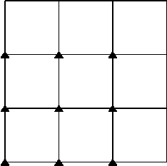
[0060] Step 12, performing the i-th division, dividing the surface of the earth into a plurality of sub-regions, and carrying out numbering, and continuing to divide and number each sub-region until each sub-region divided is related to the coding accuracy;

[0061] Step 13, obtain the number of the corresponding sub-area where the specified geographic location falls into and determine whether it falls within the boundary area of ​​the corresponding...


PUM


Abstract

The invention discloses a geographic coding method, which comprises the steps that a, the coding precision is determined according to the preset inquiring range; b, the ith division is carried out, the earth surface is divided into a plurality of sub regions, in addition, the numbering is carried out, and each sub region is continuously subjected to number division until each divided region is relevant to the coding precision; c, the fall corresponding sub region number of the specified geographic position is obtained, in addition, whether the number falls in the boundary region of the corresponding sub region or not is judged, and through coding, the one-dimensional ith geographic code and the ith boundary identification are obtained; the steps b to c are repeated for N times so that any specified geographic position at least has the boundary identification of one center region; d, N geographic codes and boundary identifications are combined. The invention also discloses a position inquiring system and a position inquiring method adopting the geographic coding method. The position inquiring system and the position inquiring method are suitable for real-time and massive inquiry of any specified position in the preset inquiring range or the approximate inquiry of nearby positions without the inquiring range.

Description

technical field [0001] The invention relates to the field of location services, in particular to a geocoding method, a location query system and method. Background technique [0002] Location Based Services (LBS) refers to the determination of the user's actual geographic location through the cooperation of mobile terminals, satellites, and mobile networks, so as to provide users with location-related service information. Geo-coding, also known as address matching, is a code set up to identify the location and attributes of points, lines, and surfaces. It selects the most suitable quantification method for all entities in accordance with a pre-drawn classification system, and selects the most appropriate quantification method according to the entity's The data structures of attribute features and set coordinates are recorded on the storage device of the computer. In location-based services, geocoding is used extensively for spatial indexing, for query sorting statistics, as...

Claims


Application Information

Patent Timeline
Patent Type & Authority Applications(China)
IPC IPC(8): G06F17/30
CPCG06F16/9537G06F16/29
Inventor 刘龙
Owner 刘龙
Why Eureka
Try Eureka