Geocoding method, location query system and method

A geocoding and geographic location technology, applied in electrical digital data processing, special data processing applications, instruments, etc., can solve problems such as increasing approximate query complexity, achieve the effect of compact space for time, and eliminate regional errors

Inactive Publication Date: 2017-12-26
刘龙
View PDF3 Cites 0 Cited by
  • Summary
  • Abstract
  • Description
  • Claims
  • Application Information

AI Technical Summary

Problems solved by technology

The current solution is to calculate all 8 subgrids around the current subgrid, but this increases the complexity of the approximate query

Method used


Image

  • Geocoding method, location query system and method
  • Geocoding method, location query system and method
  • Geocoding method, location query system and method

Examples


Embodiment Construction

[0053] In order to make the object, technical solution and advantages of the present invention clearer, the present invention will be described in detail below in conjunction with the accompanying drawings and specific embodiments.

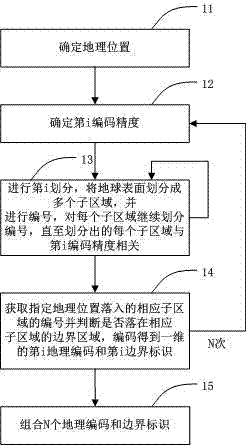
[0054] figure 1 is a schematic flow chart of the position encoding method according to the present invention. Such as figure 1 Shown, according to the location coding method of the present invention, comprise the steps:

[0055] Step 11, determine the geographic location, the geographic location is usually represented by the latitude and longitude of the double type, and can also be expressed in other forms, which can be separated / extracted from information or web pages, and can also be specified by the user;

[0056] Step 12, determining the i-th encoding precision;

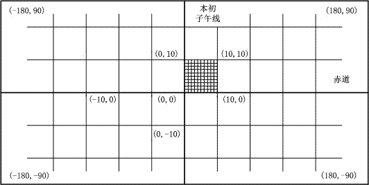
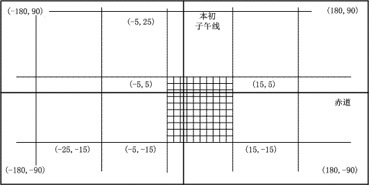
[0057] Step 13, perform the i-th division, divide the surface of the earth into multiple sub-regions, and carry out numbering, and continue to divide and number each sub-region u...


PUM


Abstract

The invention discloses a geographic coding method comprises the following steps: a. confirming geographic positions; b. confirming a No. i coding precision; c. carrying out No. i partition, so as to partition the surface of the earth into a plurality of subsections; numbering, that is, each subsection is partitioned and coded continuously till each partitioned subsection is related to the No. i coding precision; d. acquiring the number of an assigned geographic position in a corresponding subsection, judging whether the assigned geographic position is in the boundary area of the corresponding subsection or not, and coding to obtain a one-dimensional No. i geographic code and a one-dimensional No. i boundary mark; repeating the steps b to d for N times; e. combining the N geographic codes and N boundary marks. The invention further discloses a position inquiring system and method adopting the geographic coding method. According to the invention, approximate inquiry of an optional assigned position from an optional assigned range and neighboring positions can be realized conveniently and fast; suitability for fast mass position matching approximate inquiry is realized.

Description

technical field [0001] The invention relates to the field of location services, in particular to a geocoding method, a location query system and method. Background technique [0002] Location Based Services (LBS) refers to the determination of the user's actual geographic location through the cooperation of mobile terminals, satellites, and mobile networks, so as to provide users with location-related service information. Geo-coding, also known as address matching, is a code set up to identify the location and attributes of points, lines, and surfaces. It selects the most suitable quantification method for all entities in accordance with a pre-drawn classification system, and selects the most appropriate quantification method according to the entity's The data structures of attribute features and set coordinates are recorded on the storage device of the computer. In location-based services, geocoding is used extensively for spatial indexing, for query sorting statistics, as...

Claims


Application Information

Patent Timeline
Patent Type & Authority Patents(China)
IPC IPC(8): G06F17/30
CPCY02A90/10
Inventor 刘龙
Owner 刘龙
Why Eureka
Try Eureka