Fuzzy search GPS receiver rough time positioning method based on inter-satellite distance compression

A GPS receiver, inter-satellite distance technology, applied in satellite radio beacon positioning systems, measuring devices, instruments, etc., can solve problems such as millisecond integer recovery errors and positioning results errors.

Inactive Publication Date: 2016-05-11
NAT UNIV OF DEFENSE TECH
View PDF3 Cites 6 Cited by
  • Summary
  • Abstract
  • Description
  • Claims
  • Application Information

AI Technical Summary

Problems solved by technology

However, the time-free method has restrictions on the user's approximate position and approximate time, that is, only when the pseudo-range error caused by the receiver's approximate position error and approximate time does not exceed 150km, otherwise it will cause an error in the recovery of the integer number of milliseconds, resulting in positioning wrong result

Method used


Image

  • Fuzzy search GPS receiver rough time positioning method based on inter-satellite distance compression
  • Fuzzy search GPS receiver rough time positioning method based on inter-satellite distance compression
  • Fuzzy search GPS receiver rough time positioning method based on inter-satellite distance compression

Examples


Embodiment Construction

[0043] The present invention will be further described in detail below in conjunction with specific embodiments and accompanying drawings.

[0044] The coarse-time positioning method of the fuzzy search GPS receiver based on inter-satellite distance compression will be described in detail below in conjunction with the accompanying drawings.

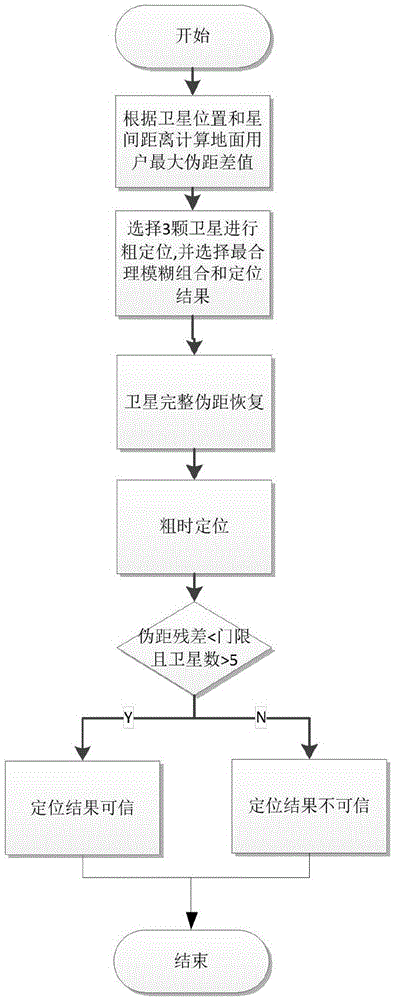
[0045] figure 2 It is a schematic flow diagram of the principle of the technical solution of the present invention, as shown in the figure, comprising the following steps:

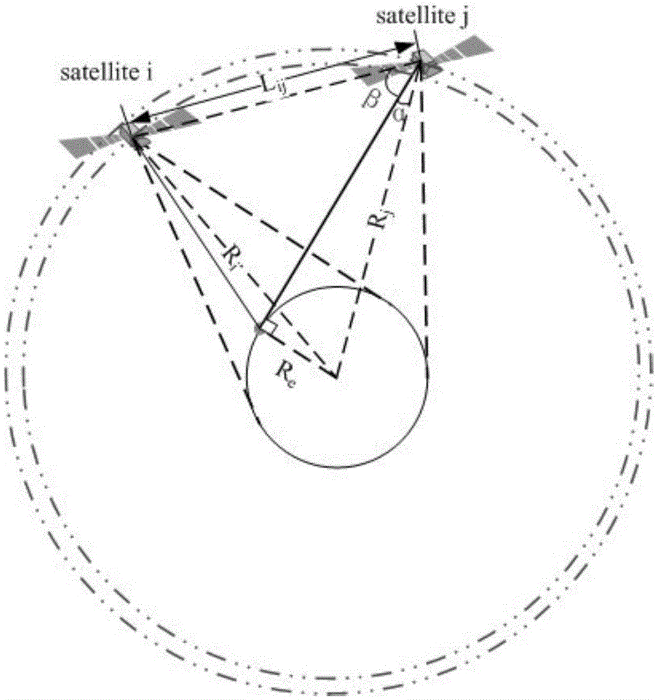
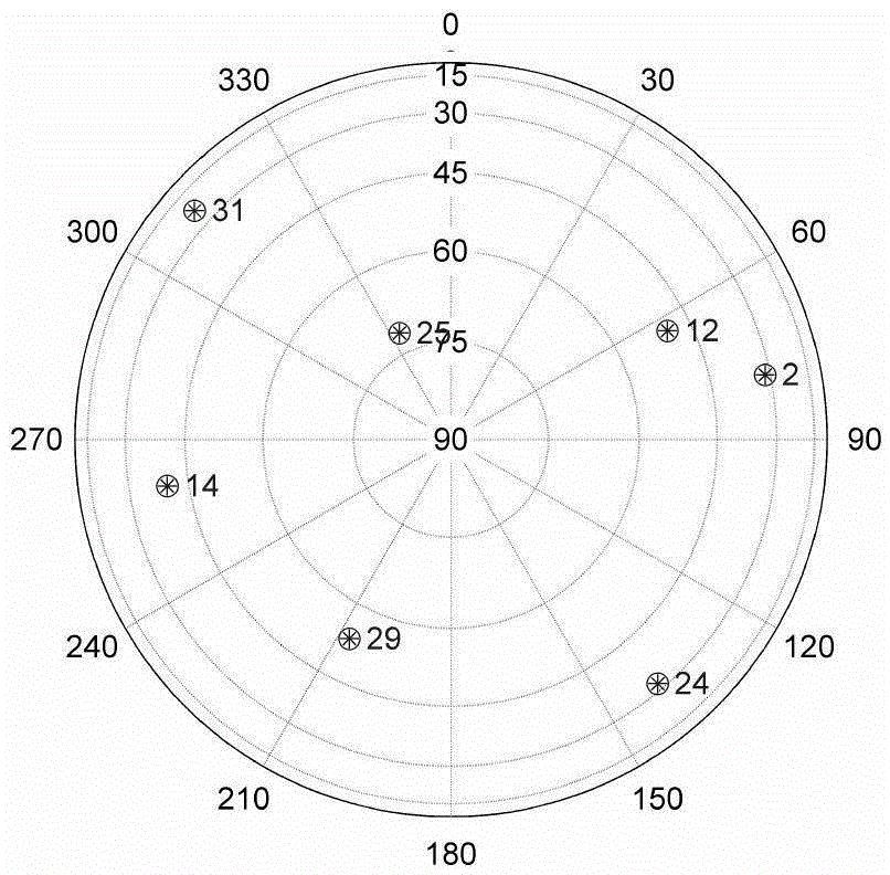
[0046] Step S1, calculating the maximum difference in pseudo-range between user-observed satellites according to the inter-satellite distance. figure 1 The relationship between the inter-satellite distance and the maximum pseudo-range difference is illustrated, so the maximum pseudo-range difference can be obtained by calculating the inter-satellite distance, which is used to constrain the search space later. image 3 Given the sky map of the example, a total of 7 ...


PUM


Abstract

A rough position is needed to assist a conventional rough time positioning method. For the condition of an unknown rough position, the space transmission finiteness of navigation signals is utilized, a fuzzy search GPS receiver rough time positioning method based on inter-satellite distance compression is provided to expand the application range of a conventional rough time positioning method, and inter-satellite distance compression is utilized to search for space. The method comprises the steps of: firstly, according to an inter-satellite distance, calculating a maximum pseudo range difference range between satellites; secondly, selecting three satellites in combination with elevation to carry out rough positioning on all fuzzy combined conditions, and according to pseudo range remains of all satellites after the positioning, selecting most reasonable fuzzy combination and positioning results; then according to the rough positioning result, restoring pseudo range fuzzy of all the satellite; and finally, using a five-state time-free positioning technology to estimate the position of a user. According to the invention, the rough time positioning is realized under the condition that the rough position is unknown, and the application range of rough time positioning is expanded.

Description

technical field [0001] The invention relates to the field of satellite navigation receiver development, in particular to a receiver time-free positioning method under the condition of unknown user position, which can be applied to specific research and development of various navigation receiving terminals. Background technique [0002] The time-free positioning technology can realize fast positioning before completing frame synchronization to obtain a complete pseudo-range, which can shorten the time for the first positioning and is used in harsh conditions such as weak signals and occlusions where it is difficult to achieve frame synchronization for a long time. In 1995, Peterson et al. proposed the five-state equation for the first time and proposed the term coarse time. Assuming that the prior position deviation and the coarse time error are small enough to keep the residual less than 0.5 milliseconds, the coarse time positioning problem is studied by constructing a modul...

Claims


Application Information

Patent Timeline
Patent Type & Authority Applications(China)
IPC IPC(8): G01S19/44
CPCG01S19/44
Inventor 刘文祥靖守让陈华明吴鹏徐博王扬钧黄龙苏映雪李彩华
Owner NAT UNIV OF DEFENSE TECH
Why Eureka
Try Eureka