Intelligent road navigation system and method based on big data

An intelligent navigation and big data technology, applied in the field of intelligent navigation, can solve problems such as rigidity, lagging navigation routes of map resources, and poor travel experience of users, so as to achieve the effect of ensuring accuracy, improving travel navigation experience, and ensuring accuracy

Pending Publication Date: 2021-11-26
苏州玛旭自动化科技有限公司
View PDF7 Cites 0 Cited by
  • Summary
  • Abstract
  • Description
  • Claims
  • Application Information

AI Technical Summary

Problems solved by technology

[0005] In order to improve the problem that the map resources of the existing car navigation system are lagging behind and the navigation route is relatively rigid and cannot provide intelligent navig

Method used


Image

  • Intelligent road navigation system and method based on big data
  • Intelligent road navigation system and method based on big data
  • Intelligent road navigation system and method based on big data

Examples


Embodiment Construction

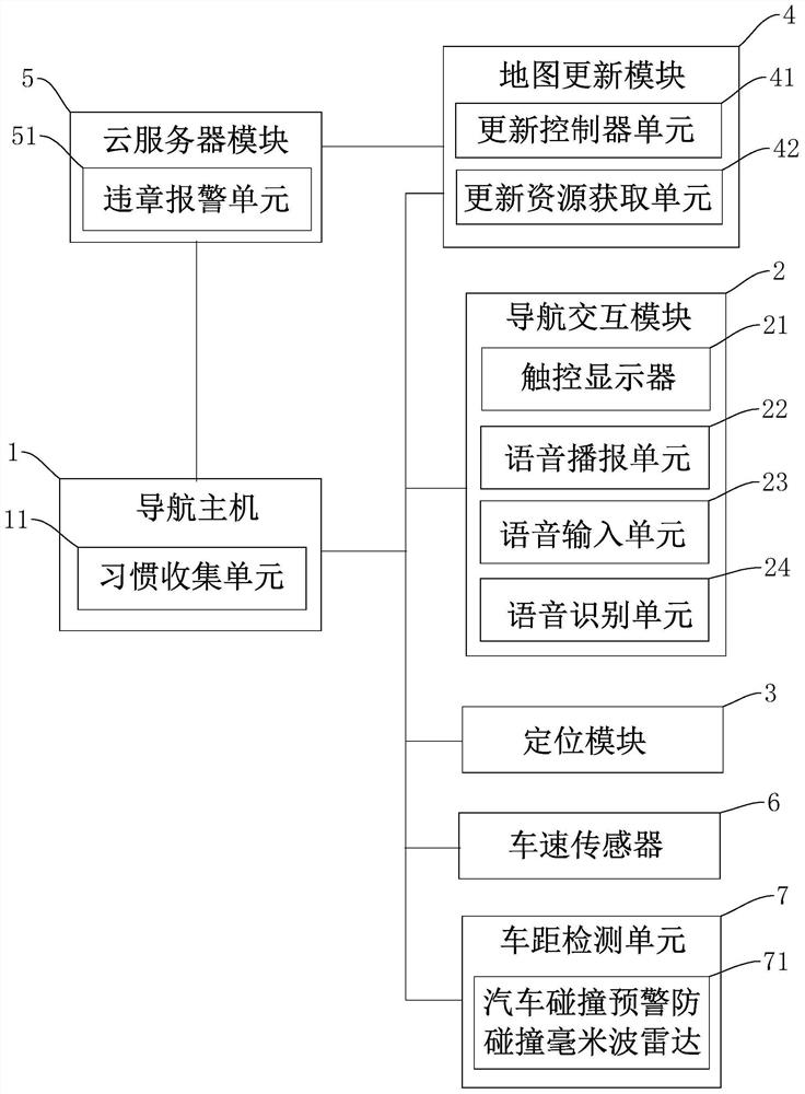
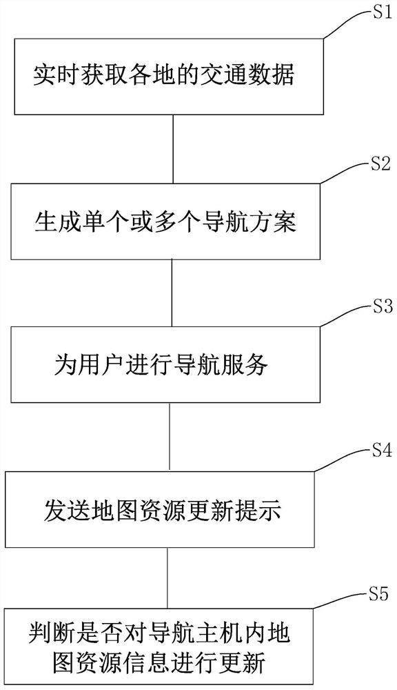
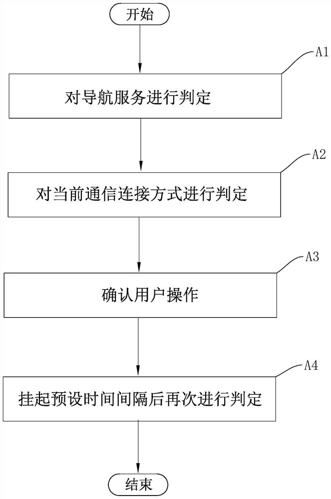
[0059] The following is attached Figure 1-3 The application is described in further detail.

[0060] The embodiment of the application discloses a road intelligent navigation system based on big data. refer to figure 1 , a road intelligent navigation system based on big data, including a navigation host 1, a navigation interaction module 2, a positioning module 3, a map update module 4 and a cloud server module 5. The navigation interaction module 2 , the positioning module 3 and the map update module 4 are all connected to the navigation host 1 , and the navigation host 1 and the map update module 4 are all connected to the cloud server module 5 through communication. The navigation host 1 is used to plan the driving route for the user according to the user's navigation needs in combination with the traffic data obtained in real time from the cloud server module to generate a single or multiple navigation solutions for the user to choose. The navigation interaction module...


PUM


Abstract

The invention relates to an intelligent road navigation system and method based on big data. The navigation system comprises a navigation host, a navigation interaction module, a positioning module, a map updating module and a cloud server module, wherein the navigation host is used for generating one or more navigation schemes for a user to plan a driving path according to a user navigation demand in combination with traffic data acquired from the cloud server module in real time; the cloud server module is used for acquiring, updating and storing map resource information in real time, and sending a map resource updating prompt to the map updating module of each user when the map resource information is updated; the map updating module judges whether to update map resource information in the navigation host according to a preset updating rule and a user operation instruction after receiving the map resource updating prompt; and the cloud server module is connected with each urban traffic command center to obtain traffic data of each place in real time. The intelligent road navigation system and method provided by the invention have the effect of intelligently providing navigation service for users.

Description

technical field [0001] The present application relates to the field of intelligent navigation, in particular to a road intelligent navigation system and navigation method based on big data. Background technique [0002] With the rapid development of my country's economy, cars have entered thousands of households and become an important means of transportation for people's daily travel, and the navigation system has also developed rapidly with the increase in car ownership. In the navigation process, the selection of the route is a very important link, usually taking into account the distance, time, and whether there is congestion or not. [0003] Car Navigation (Car Navigation) is a driving assistance device that can help users accurately locate the current location, calculate the itinerary according to the established destination, and guide the user to the destination through map display and voice prompts. The operation of the car navigator mainly depends on the Global Pos...

Claims


Application Information

Patent Timeline
IPC IPC(8): G01C21/34
CPCG01C21/3492G01C21/3484
Inventor 刘宝银
Owner 苏州玛旭自动化科技有限公司
Why Eureka
Try Eureka