Navigation system and method for displaying map on navigation system

a navigation system and navigation system technology, applied in the direction of navigation instruments, static indicating devices, instruments, etc., can solve the problems of not being able to keep the latest, traffic congestion, and worsening traffic congestion, so as to minimize the difference between data and enhance the quality of the map, smooth overlap

Active Publication Date: 2014-10-09
HYUNDAI AUTOEVER
View PDF3 Cites 7 Cited by
  • Summary
  • Abstract
  • Description
  • Claims
  • Application Information

AI Technical Summary

Benefits of technology

[0024]As described above, in a navigation system and a method for displaying a map on the navigation system in accordance with the embodiments of the present invention, it is possible to display a newly updated map produced by composing a numerical map and a photomap together and thus to enhance a quality of the map by displaying a real space when displaying the map.
[0025]Further, in a navigation system and a method for displaying a map on the navigation system in accordance with the embodiments of the present invention, it is possible to minimize a sense of the difference between data by smoothly overlapping a numerical map with a photomap with a controlled transparency at a boundary of them when displaying the map on a navigation system, thereby embodying a natural guide image.

Problems solved by technology

Currently, as the number of moving bodies such as a vehicle continues to increase, the traffic congestion becomes worse and worse.
Further, since the increasing speed of the number of the moving bodies is becoming faster than that of the infrastructure such as road, there occur severe problems such as a traffic congestion.
However, in case of providing the photomaps only, it may not be possible to keep them latest due to the difference between the time point when an aerial photograph or a satellite photograph is taken and the time point when it is updated.
Therefore, there occurs a problem in that an image of a newly opened road or closed road is not timely reflected and provided.

Method used


Image

  • Navigation system and method for displaying map on navigation system
  • Navigation system and method for displaying map on navigation system
  • Navigation system and method for displaying map on navigation system

Examples


Embodiment Construction

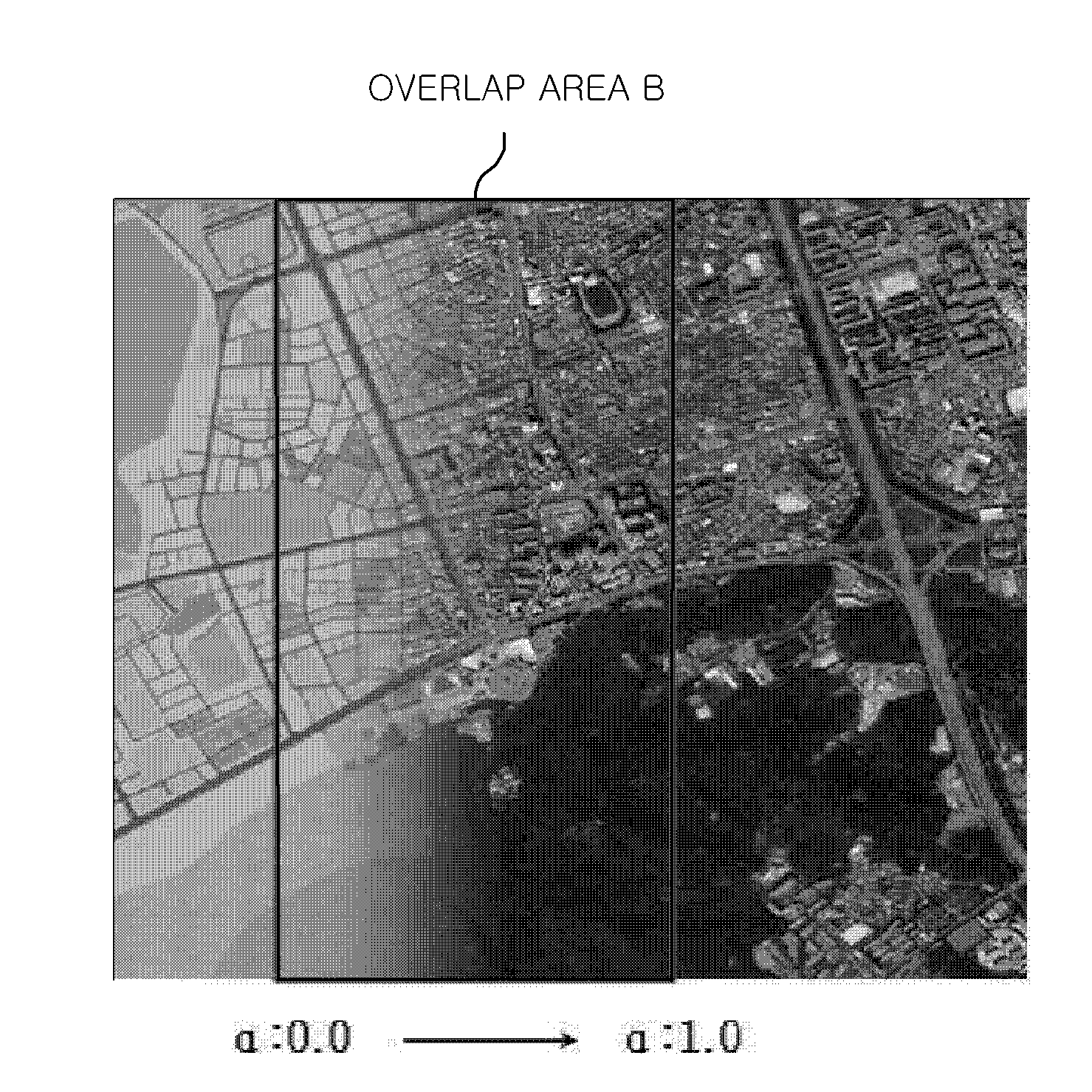
[0034]Hereinafter, an embodiment of a method for displaying a map on a navigation system in accordance with the present invention will be described with reference to the accompanying drawings. In referring to the drawings, thickness of lines and size of components shown in the drawings may be exaggerated for the purpose of descriptive clarity and for the sake of convenience. Further, the following terms are defined in consideration of the functions of the present invention, which may vary depending on the intentions of a user or an operator or practices. Therefore, the definition of such terms should be made on the basis of the disclosure throughout the present specification.

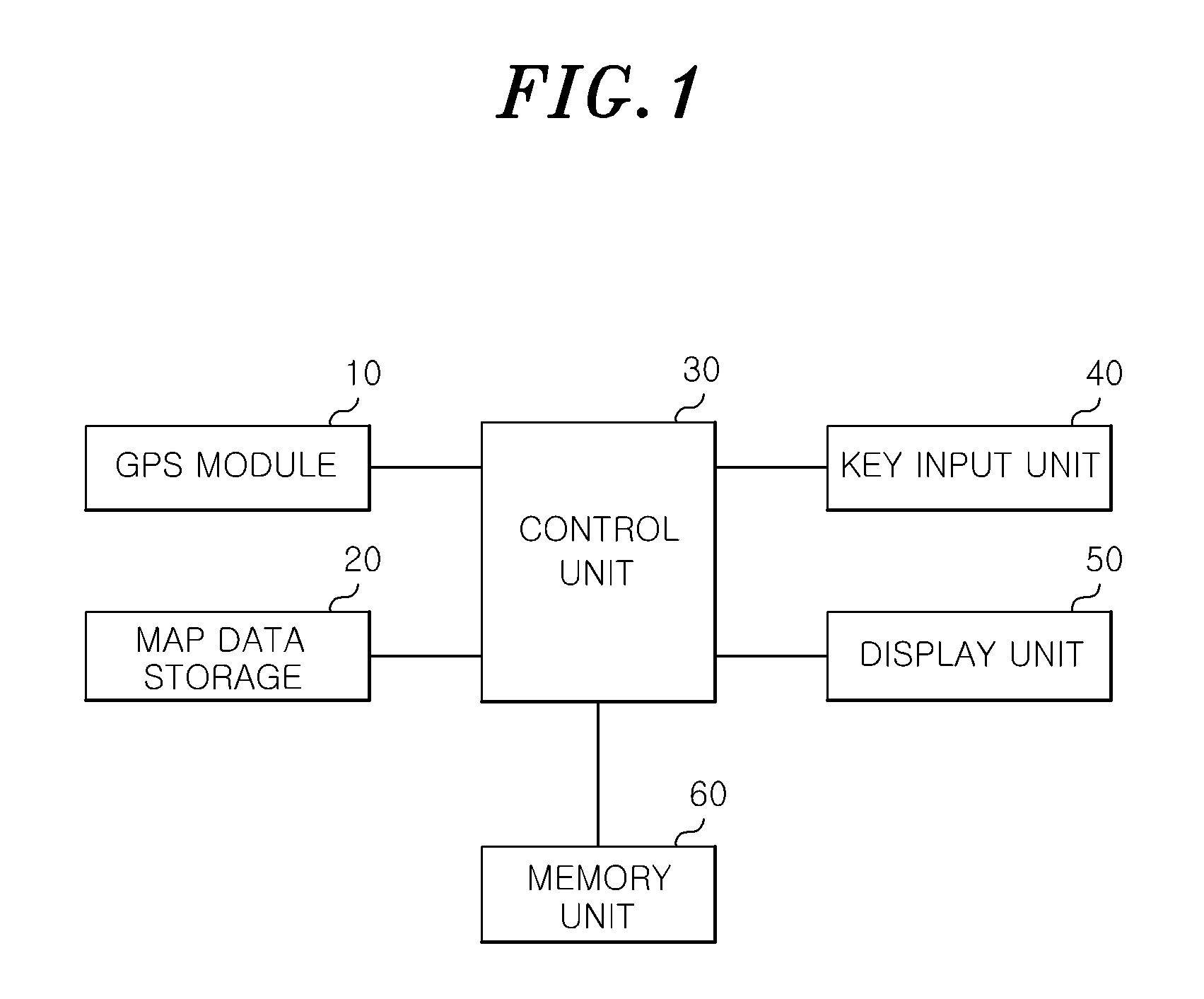
[0035]FIG. 1 is a block diagram of a navigation system in accordance with an embodiment of the present invention.

[0036]As illustrated in FIG. 1, the navigation system includes a GPS module 10, a map data storage 20, a memory unit 60, a key input unit 40, a control unit 30, and a display unit 50.

[0037]The GPS mod...


PUM


Abstract

A method for displaying a map performed by a navigation system, the method comprising: defining a matching area of a numerical map to which a photomap is matched; extracting the photomap corresponding to the matching area from a map data storage; matching a reference point of the photomap and a reference point of the numerical map; matching a scale of the photomap in line with a scale of the numerical map; and performing a boundary treatment at an overlap area of the numerical map and the photomap that are matched.

Description

RELATED APPLICATIONS[0001]This application claims the benefit of Korean Patent Application No. 10-2013-0038342, filed on Apr. 8, 2013, which is hereby incorporated by reference as if fully set forth herein.FIELD OF THE INVENTION[0002]The present invention relates to a navigation system and a method for displaying a map on the navigation system. More specifically, the present invention relates to a navigation system and a method for displaying a map on the navigation system, capable of displaying the map that is produced by composing a numerical map and a photomap when displaying the map on the navigation system.BACKGROUND OF THE INVENTION[0003]Currently, as the number of moving bodies such as a vehicle continues to increase, the traffic congestion becomes worse and worse. Further, since the increasing speed of the number of the moving bodies is becoming faster than that of the infrastructure such as road, there occur severe problems such as a traffic congestion.[0004]In such a situa...

Claims


Application Information

Patent Timeline
Patent Type & Authority Applications(United States)
IPC IPC(8): G01C21/26G06T11/00
CPCG06T11/001G01C21/26G01C21/32G01C21/3867G01C21/3852G09B29/10G08G1/0969G01C21/3647G01C21/3815G01C21/3863
Inventor KIM, SANG, HUN
Owner HYUNDAI AUTOEVER
Why Eureka
Try Eureka