Intelligent territory space planning digital display system

A technology of space planning and display system, which is applied in the fields of electronic digital data processing, digital data information retrieval, special data processing applications, etc. The effect of convenient and reasonable planning

Inactive Publication Date: 2019-07-12
武汉零点视觉数字科技有限公司
View PDF1 Cites 10 Cited by
  • Summary
  • Abstract
  • Description
  • Claims
  • Application Information

AI Technical Summary

Problems solved by technology

[0005] Aiming at the deficiencies of the prior art, the present invention provides a digital display system for smart land space planning, which solves the problem that it takes a lot of time to organize data and plan, wastes a lot of time and manpower, and cannot realize the effect of classification and planning display The problem

Method used


Image

  • Intelligent territory space planning digital display system
  • Intelligent territory space planning digital display system
  • Intelligent territory space planning digital display system

Examples


Embodiment Construction

[0021] The following will clearly and completely describe the technical solutions in the embodiments of the present invention with reference to the accompanying drawings in the embodiments of the present invention. Obviously, the described embodiments are only some, not all, embodiments of the present invention. Based on the embodiments of the present invention, all other embodiments obtained by persons of ordinary skill in the art without making creative efforts belong to the protection scope of the present invention.

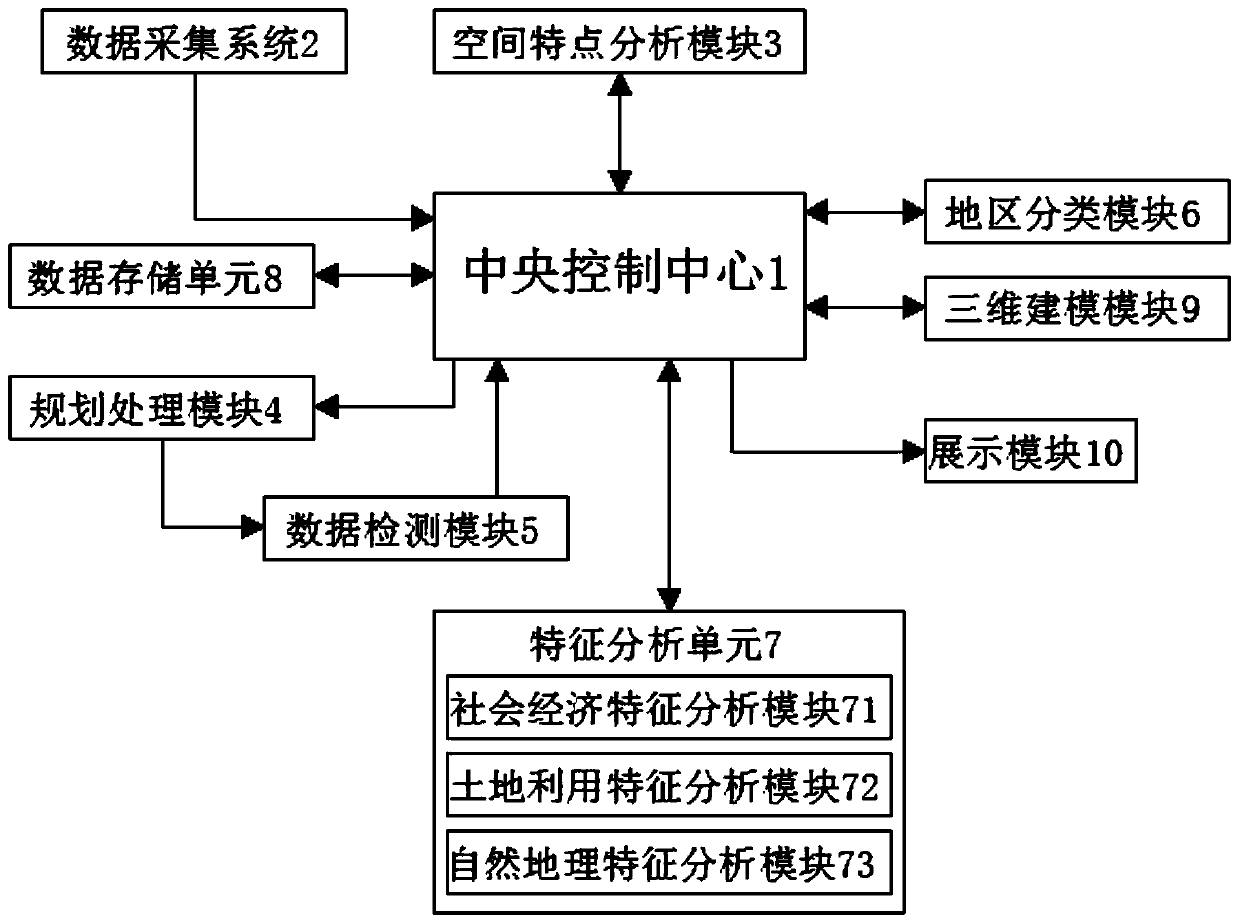
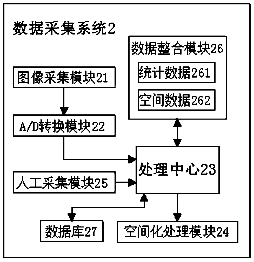
[0022] see Figure 1-2 , the embodiment of the present invention provides a technical solution: a digital display system for intelligent land and space planning, including a central control center 1 and a data acquisition system 2, using an intelligent data acquisition system 2 to collect data in various regions, and through Reasonable data processing for data integration and analysis, to a certain extent, facilitates rational planning of the country and impro...


PUM


Abstract

The invention discloses an intelligent territory space planning digital display system. The system comprises a central control center and a data acquisition system. The output end of the data acquisition system is connected with the input end of the central control center, the central control center is in bidirectional connection with the spatial characteristic analysis module, and the output endof the central control center is connected with the input end of the planning processing module. The invention relates to the technical field of digital display systems. In the intelligent territory space planning digital display system, the output end of the data acquisition system is connected with the input end of the central control center, an intelligent data acquisition system is adopted toacquire data of each region. Through integrated analysis of data and reasonable data processing, territory can be reasonably planned conveniently. The working efficiency is improved, the planning datacan be quickly displayed, meanwhile, the displayed data can be classified and integrated, and people can watch and understand the planning data more conveniently through modular display.

Description

technical field [0001] The invention relates to the technical field of digital display systems, in particular to a digital display system for smart land space planning. Background technique [0002] Spatial planning is mainly used by the public sector to affect the spatial distribution of future activities. Its purpose is to create a more reasonable territorial organization of land use and functional relationships, and to balance the two needs of environmental protection and development to achieve overall social and economic development. The digital display industry takes digital images as the core, and combines three-dimensional digital images with touch screens, infrared sensors, projections and other hardware to present different display methods, emphasizing the functionality of display, experience, and interaction. The CG (digital image) industry is closer to the display industry. It is a higher-level display industry generated by the combination of three-dimensional dig...

Claims


Application Information

Patent Timeline
Patent Type & Authority Applications(China)
IPC IPC(8): G06F16/248
Inventor 李振波吴限周维蒋兆龙邢宸余朝波王文波祝威
Owner 武汉零点视觉数字科技有限公司
Why Eureka
Try Eureka