Framing model and framing method for large-scale digital topographic map

A topographic map and scale technology, applied in the field of surveying and mapping engineering, can solve the problems of inconvenient use of topographic map results, poor aesthetics, and large number of files, so as to reduce the workload of framing, reduce editing and modification, and save storage space Effect

Inactive Publication Date: 2020-05-15
CHINA POWER CONSRTUCTION GRP GUIYANG SURVEY & DESIGN INST CO LTD
View PDF2 Cites 5 Cited by
  • Summary
  • Abstract
  • Description
  • Claims
  • Application Information

AI Technical Summary

Problems solved by technology

But there are also some disadvantages: ①Physical cutting forms independent framed image files, the number of files is large, the storage space is large, and it is difficult to print out images in batches
②The framed image files and framed combined charts are named and automatically marked with the coordinates of the lower left corner of the frame, which is poor in aesthetics and inconvenient for query and use
If the map frame needs to be named according to the serial number of the survey area, the characteristic features or place names in the topographic map, the modification of the file name and other content will require a lot of work
③Batch automatic framing and cutting, unable to identify blank map frames, need to manually identify and delete blank map frame files and edit measurement area frame combination map, map frame combination table, error-prone, and heavy processing workload
④ The workload of quality control and revision of the framing map is heavy
The quality control of topographic maps is usually carried out according to the map frame. Firstly, it is necessary to increase the frame border inspection process during the quality inspection. Second, after the map frame is modified, it is necessary to carry out map frame border inspection. If necessary, the general topographic map of the survey area must be modified. , which increases the workload of the office; when carrying out the repair survey of the existing topographic map, it is usually carried out on the general topographic map of the survey area.
⑤ Topographic map results are inconvenient to use
Usually the area of ​​the project area is relatively large, and the results of the whole or subregional topographic maps are needed in the process of project construction. The map users also need to piece together the fragmented maps one by one into a general topographic map of the region, and delete the map outline annotations, etc., if necessary At the same time, it is necessary to check the connection of elements such as ground objects and contour lines, which makes it inconvenient to use

Method used


Image

  • Framing model and framing method for large-scale digital topographic map
  • Framing model and framing method for large-scale digital topographic map
  • Framing model and framing method for large-scale digital topographic map

Examples


Embodiment Construction

[0044] The present invention will be further described below in conjunction with the accompanying drawings and embodiments, but not as a basis for limiting the present invention.

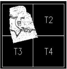
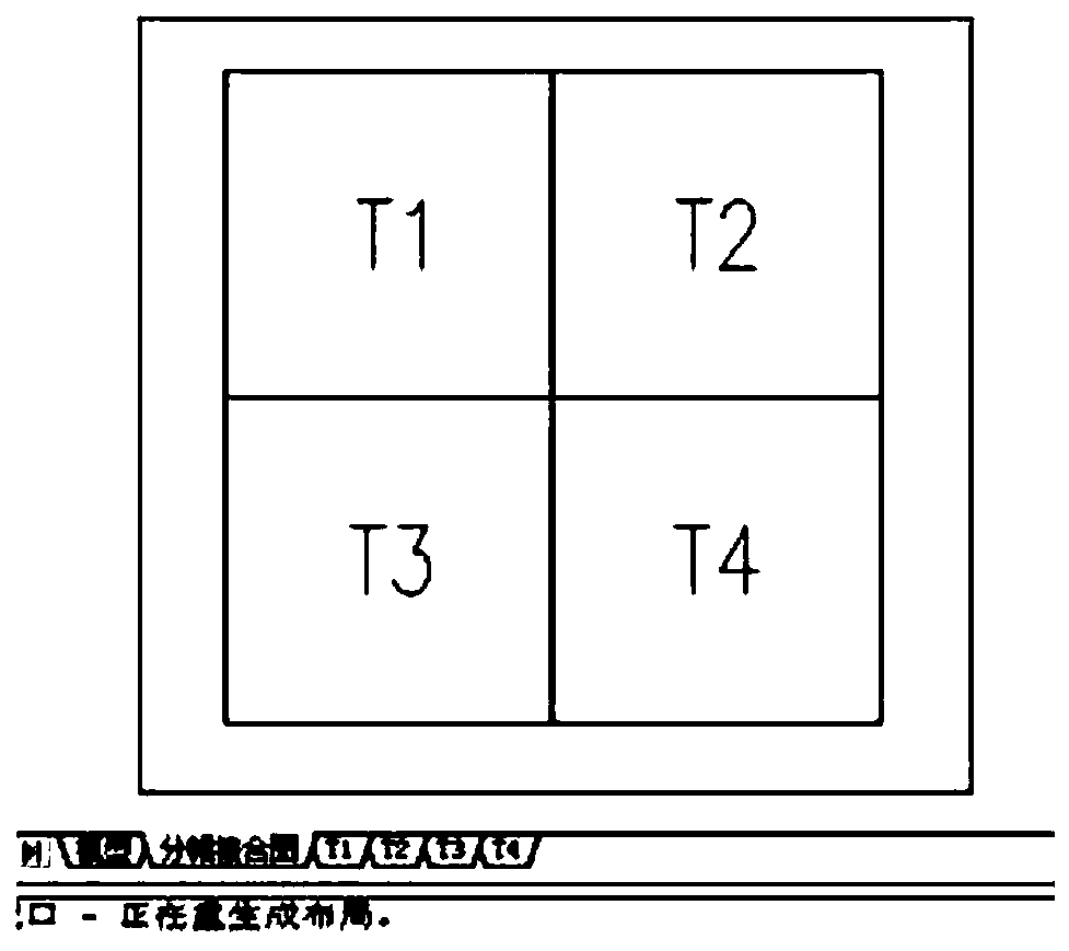
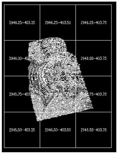
[0045] Example. A framing model of a large-scale digital topographic map, including a graphic framing sub-module, which is used to: divide the general topographic map into corresponding framing according to the set framing scale, framing specification, and framing range parameters Topographic and / or tiled maps;

[0046] The layout creation sub-module is used to: sequentially output the framing topographic map and / or framing joint map in the form of layout space;

[0047] The viewport creation sub-module is used for: creating a viewport in the layout, and displaying the graphic content of the tiled topographic map / or tiled joint map in the viewport.

[0048] The aforementioned framing model also includes a frame deletion sub-module, which is used for: before framing, delete the original frame in th...


PUM


Abstract

The invention discloses a framing model and a framing method for a large-scale digital topographic map. The framing model comprises a graph framing sub-module, wherein the graph framing sub-module isused for segmenting a topographic map into a corresponding framing topographic map and / or a framing joint map according to a set framing scale, a framing specification and a framing range parameter; alayout creation sub-module which is used for sequentially outputting the framing topographic map and / or the framing joint map in a layout space form; and a viewport creation sub-module which is usedfor creating a viewport in the layout and displaying the graphic content of the framing topographic map / or the framing joint map in the viewport. The framing model and the framing method has the advantages of being small in file occupied storage space, small in file number, easy and convenient to modify, small in repairing, testing and editing workload and convenient to use.

Description

technical field [0001] The invention relates to the technical field of surveying and mapping engineering, in particular to a framing model and a framing method of a large-scale digital topographic map. Background technique [0002] In the surveying and mapping production of large-scale digital topographic maps in surveying and mapping engineering, when submitting the final results, it is necessary to cut the topographic map of the survey area (large graphic file) into standard small graphic files according to the specification requirements, and then apply the standard frame, Numbering one by one and trimming the figure outline to form a framed map, and finally print out the map and submit it to the owner for archiving. [0003] "Large-scale digital topographic map" refers to the scales determined in accordance with relevant measurement standards (including commonly used 1:100, 1:200, 1:500, 1:1000, 1:2000, 1:5000), produced by digital surveying and mapping technology The ve...

Claims


Application Information

Patent Timeline
Patent Type & Authority Applications(China)
IPC IPC(8): G06T11/20
CPCG06T11/206
Inventor 黎杰吴新广
Owner CHINA POWER CONSRTUCTION GRP GUIYANG SURVEY & DESIGN INST CO LTD
Why Eureka
Try Eureka