Vehicle positioning implementing method

A vehicle positioning and implementation method technology, applied in the field of navigation and positioning, can solve the problems of large error, inapplicability, and divergence of direction sensors, and achieve the effect of continuous positioning

Active Publication Date: 2009-09-30
SICHUAN CHANGHONG ELECTRIC CO LTD
View PDF0 Cites 38 Cited by
  • Summary
  • Abstract
  • Description
  • Claims
  • Application Information

AI Technical Summary

Problems solved by technology

However, the GPS signal may be blocked under tall buildings and under the shade of trees, resulting in temporary failure of GPS positioning or continuous positioning
DR uses the direction and speed sensors to estimate the vehicle position. For short-distance positioning, the measurement accuracy is high, but the error of the direction sensor is large, and the accumulation will diverge over time, so it is not suitable for long-distance positioning.

Method used


Image

  • Vehicle positioning implementing method
  • Vehicle positioning implementing method
  • Vehicle positioning implementing method

Examples


Embodiment

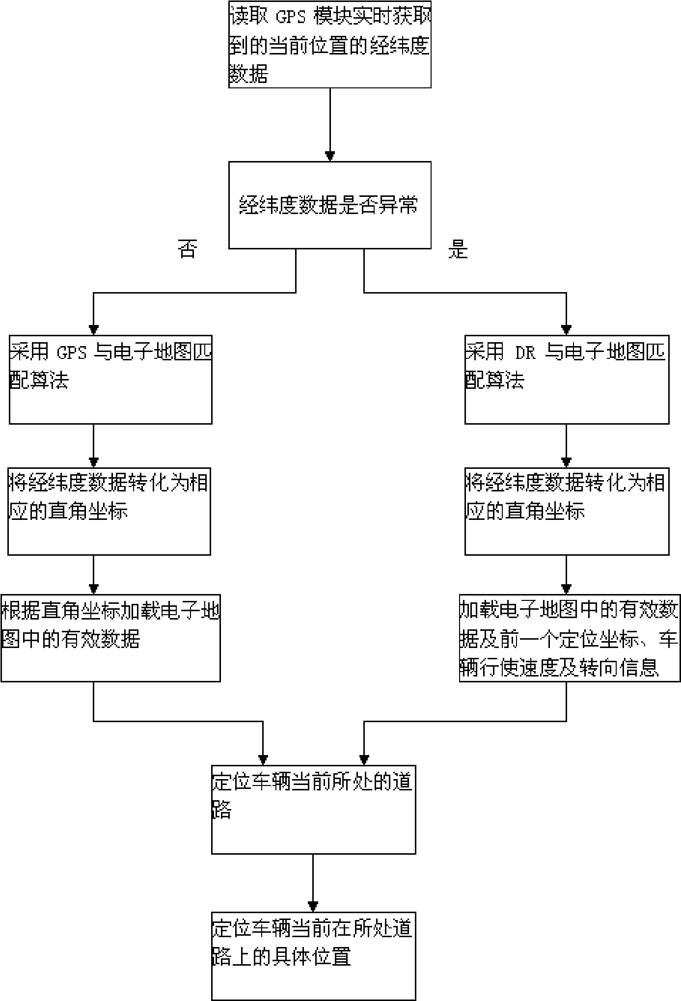
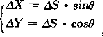
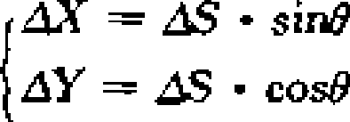
[0026] The vehicle positioning implementation steps in this example are as follows: it is divided into four major steps: 1. GPS data preprocessing process: read the latitude and longitude data of the current position acquired by the GPS module in real time. 2. Selection of map matching method: when the data acquired by the GPS module is abnormal or there is no data, it will automatically switch to the DR and electronic map matching algorithm; when the data acquired by the GPS module is normal, it will automatically switch to the GPS and electronic map matching algorithm. 3. Conversion of latitude and longitude data and loading of map data: a. Convert real-time latitude and longitude data into corresponding Cartesian coordinates; b. data in the range). 4. Determination of the road section of the vehicle: At this time, different positioning implementation methods need to be selected according to different matching methods, but the basic idea is still the following two points: a....


PUM


Abstract

The invention relates to a navigation positioning technology, particularly an implementing method for vehicle positioning. The invention discloses a vehicle positioning implementing method aiming at the disadvantages of GPS and DR in prior art and combining GPS and DR to implement positioning with high efficiency, accuracy and continuation. The key points of the technical scheme are as follows: judging whether the latitude and longitude data obtained from GPS is abnormal, if not, then figuring out the vehicle current road and the specific position on the road by a matching algorithm of GPS and electronic map, if yes, then figuring out the vehicle current road and the specific position on the road by a matching algorithm of DR and electronic map. The invention combines GPS and DR and is suitable for positioning vehicles with high efficiency, accuracy and continuation.

Description

technical field [0001] The invention relates to navigation and positioning technology, in particular to a method for realizing vehicle positioning. Background technique [0002] With the rapid development of intelligent transportation systems, vehicle positioning and navigation systems are also developing. Nowadays, there are mainly Global Positioning System (GPS) and Dead Position Navigation System (DR) for vehicle positioning. GPS can continuously observe at least four satellites at any place on the earth at the same time, thereby ensuring the need for global, all-weather continuous real-time positioning. However, under the shade of tall buildings and trees, the GPS signal may be blocked, resulting in temporary failure of GPS positioning or continuous positioning. DR uses direction and speed sensors to estimate the vehicle's position. For short-distance positioning, the measurement accuracy is high, but the error of the direction sensor is large, and the accumulation wil...

Claims


Application Information

Patent Timeline
Patent Type & Authority Applications(China)
IPC IPC(8): G01C21/30
Inventor 明爽
Owner SICHUAN CHANGHONG ELECTRIC CO LTD
Why Eureka
Try Eureka