Energy optimization navigation unit based on combined navigation

A technology for energy optimization and navigation devices, applied in measuring devices, radio wave measurement systems, satellite radio beacon positioning systems, etc., can solve problems such as high power consumption and cumulative errors, and achieve low power consumption, low external environment dependence, Effect of Power Consumption Reduction

Inactive Publication Date: 2012-08-22
SHANGHAI JIAO TONG UNIV
View PDF5 Cites 6 Cited by
  • Summary
  • Abstract
  • Description
  • Claims
  • Application Information

AI Technical Summary

Problems solved by technology

The device combines the advantages of GNSS receivers and inertial navigation devices with high navigation accuracy, low power consumption, and low requirements for external conditions. Requirements for Mobile Low Power Navigation Devices

Method used


Image

  • Energy optimization navigation unit based on combined navigation
  • Energy optimization navigation unit based on combined navigation
  • Energy optimization navigation unit based on combined navigation

Examples


Embodiment Construction

[0028] The idea, specific structure and technical effects of the present invention will be further described below in conjunction with the accompanying drawings, so as to fully understand the purpose, features and effects of the present invention.

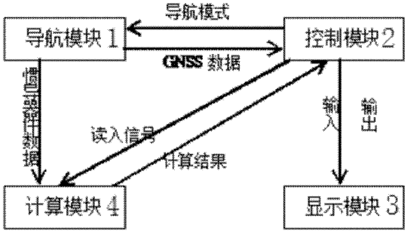
[0029] Such as figure 1 As shown, the energy-optimized navigation device based on integrated navigation of the present invention includes: a navigation module 1, a calculation module 4, a control module 2 and a display module 3, wherein the navigation module 1, the calculation module 4 and the display module 3 are all connected to the control module 2 The navigation module 1 is connected with the calculation module 4 again.

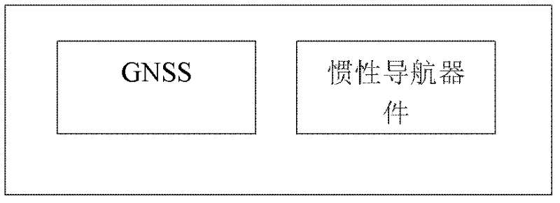
[0030] Specifically, the navigation module 1 is used to receive the original navigation data, and send the received original navigation data to the calculation module.

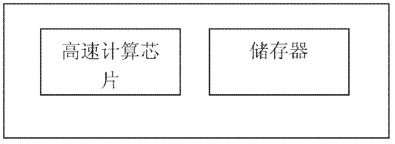
[0031] The computing module 4 is used to perform arithmetic processing on the original navigation data output by the navigation module 1 , a...


PUM


Abstract

The invention discloses an energy optimization navigation unit based on combined navigation, which comprises a navigation module, a computation module, a control module and a display module. The navigation module, the computation module and the display module are connected with the control module, and the navigation module is further connected with the computation module. The energy optimization navigation unit is a handheld energy optimization GNSS (global navigation satellite system) receiver based on an inertial navigation device, and the handheld energy optimization GNSS receiver integrates advantages, including high precision, low power consumption, high independency and external interference resistance, of the inertial navigation device and a common GNSS receiver. On the premise of guaranteeing the navigation precision and sensitivity, the power consumption can be reduced to be 21% of the original power consumption. In addition, compared with the pure inertial navigation device, the energy optimization navigation unit can effectively control accumulated errors on the premise of keeping low power consumption and low dependency on external environments.

Description

technical field [0001] The present invention relates to a navigation device, in particular to an energy-optimized navigation device based on integrated navigation. Background technique [0002] Navigation technology is a technology that uses the information provided by satellites / sensors and other devices to quickly and correctly guide the carrier to the intended destination through calculation. Navigation technology was first used in the military field, but with the development of science and technology, navigation technology has gradually moved from the military field to the civilian market. Modules with navigation functions are now installed in ships, cars and even mobile phones. These navigation modules greatly facilitate people's travel. At present, in addition to the more popular satellite navigation and inertial navigation, starlight navigation and geomagnetic navigation are also emerging navigation technologies. [0003] In actual engineering applications, inertia...

Claims


Application Information

Patent Timeline
Patent Type & Authority Applications(China)
IPC IPC(8): G01S19/49G01S19/23
Inventor 王翔宇宋欣毕琰周思捷
Owner SHANGHAI JIAO TONG UNIV
Why Eureka
Try Eureka