Method for realizing airborne long-endurance celestial navigation system based on INS (inertial navigation system) correction

An astronomical navigation and long-endurance technology, applied in the field of long-endurance aviation aircraft navigation, can solve the problem of low positioning accuracy of the inertial navigation system

Active Publication Date: 2015-04-29
XI'AN INST OF OPTICS & FINE MECHANICS - CHINESE ACAD OF SCI
View PDF4 Cites 11 Cited by
  • Summary
  • Abstract
  • Description
  • Claims
  • Application Information

AI Technical Summary

Problems solved by technology

[0004] In order to solve the technical problem that the existing celestial navigation positioning algorithm needs to observe two stars at the same time, and the positioning accuracy of the inertial navigation system is low, the present invention provides a method for improving the airborne long-endurance celestial navigation system based on INS-containing error correction items

Method used


Image

  • Method for realizing airborne long-endurance celestial navigation system based on INS (inertial navigation system) correction
  • Method for realizing airborne long-endurance celestial navigation system based on INS (inertial navigation system) correction
  • Method for realizing airborne long-endurance celestial navigation system based on INS (inertial navigation system) correction

Examples


Embodiment Construction

[0047] The present invention will be described in detail below.

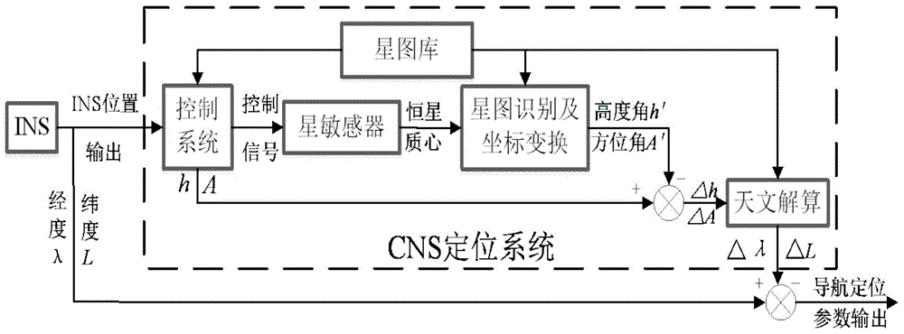
[0048] The celestial navigation system includes a star tracking observation platform and a calculation module. The main function of the star tracking platform is to calculate the best navigation star according to the received inertial navigation system information, and then control the star sensor to track and observe the best navigation star, and finally pass the star point Extraction, identification, and a series of coordinate transformations output the observed altitude h and observed azimuth A of the navigation star in the ground coordinate system to the calculation module. The main function of the calculation module is to receive the inertial navigation system information and the observation information of the star tracking platform, and then calculate the above information, and output the position information of the carrier aircraft.

[0049] Since the celestial navigation system mainly realizes the correc...


PUM


Abstract

The invention relates to a method for realizing an airborne long-endurance celestial navigation system based on INS (inertial navigation system) correction, and belongs to the technical field of navigation of long-endurance aircrafts. The method comprises the following steps: guiding a celestial observation subsystem on a physical platform with two-dimensional rotational freedom through position information output by the pure inertial navigation system to observe a fixed star target in the sky, calculating position information of a fixed star point target image in a geographic coordinate system, and correcting data accumulated along with time and output by the inertial navigation system by utilizing the calculated position information. The method realizes the airborne long-endurance high-precision celestial navigation system based on error item correction of the INS and is suitable for celestial positioning navigation on the airborne physical platform.

Description

technical field [0001] The invention relates to a method for correcting an airborne long-endurance high-precision celestial navigation system (Celastial navigation system, CNS) with an error term based on a pure inertial navigation system (Inertial navigation system, INS), which is used for long-endurance aviation aircraft navigation technology field. Background technique [0002] Celestial navigation is an ancient and young technology, which has been widely valued by people for its strong autonomy, good anti-interference, and high precision. The celestial navigation system uses the stars as the source of navigation information, which has good concealment. The celestial navigation system can output the right ascension, declination and rotation angle of the observed star, and the position information and attitude information of the carrier can be obtained by solving these information. Although astronomical navigation was neglected to a certain extent when the satellite navi...

Claims


Application Information

Patent Timeline
Patent Type & Authority Applications(China)
IPC IPC(8): G01C21/02
CPCG01C21/025G01C21/165
Inventor 邓小国杨晓许谢梅林魏宇江波唐慧君
Owner XI'AN INST OF OPTICS & FINE MECHANICS - CHINESE ACAD OF SCI
Why Eureka
Try Eureka