Agricultural drought grade monitoring method based on temperature vegetation drought index (TVDI)

A technology of drought index and vegetation index, applied in data processing applications, instruments, resources, etc., can solve problems such as discontinuity, lack of comparability, and multiple LST data in time and space

Active Publication Date: 2016-07-13
BEIJING NORMAL UNIVERSITY +1
View PDF1 Cites 48 Cited by
  • Summary
  • Abstract
  • Description
  • Claims
  • Application Information

AI Technical Summary

Problems solved by technology

However, TVDI has the following problems in the actual agricultural drought monitoring: (1) many missing values ​​make the LST data discontinuous in time and space, and TVDI canno...

Method used


Image

  • Agricultural drought grade monitoring method based on temperature vegetation drought index (TVDI)
  • Agricultural drought grade monitoring method based on temperature vegetation drought index (TVDI)
  • Agricultural drought grade monitoring method based on temperature vegetation drought index (TVDI)

Examples


Embodiment Construction

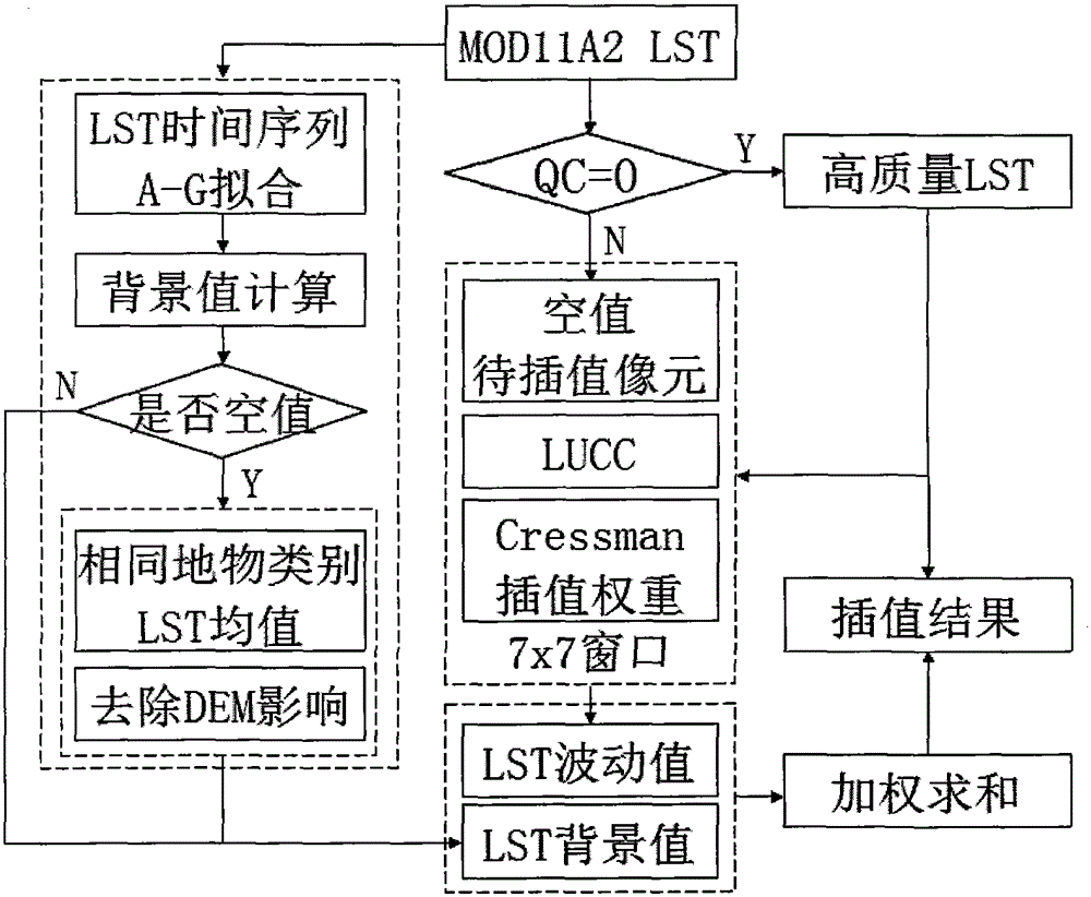
[0069] The present invention will be further elaborated below in conjunction with the accompanying drawings and specific embodiments.

[0070] This case takes Henan as the research area, and mainly uses vegetation index data products, LST data products, and land cover / land cover change data products. The various MODIS products used in this article are as follows:

[0071] Table 1 MODIS Land Products

[0072]

[0073] The multi-cropping index data of cultivated land is mainly used to obtain the spatial distribution of cultivated land pixels in Henan. The data is provided by Dr. Liu Jianhong, and the spatial resolution of the data is 500m. The data used in this case is a total of 11 scenes in Henan from 2001 to 2011, and the pixel value is annual The number of crops planted in this pixel, the non-cultivated land pixel is marked as 0, and the specific extraction algorithm for the multi-cropping index data of cultivated land is as follows:

[0074] (1) According to the multi-...


PUM


Abstract

The invention discloses an agricultural drought grade monitoring method based on a temperature vegetation drought index (TVDI). The method comprises the following steps of: 1, data preparation; 2, land surface temperature (LST) data reconstruction; 3, construction of crop plantation area normalized difference vegetation index-land surface temperature (NDVI-LST) feature space; 4, TVDI calculation; and 5, drought grade monitoring based on the TVDI. The invention brings forward an LST data reconstruction method based on multi-year background values and area fluctuation values, a cultivated land area multi-year NDVI-LST feature space is constructed for crops, the TVDI is calculated, a crop drought grade monitoring model based on a supervision classification idea is designed for drought grade remote sensing monitoring, the model can quite accurately reflect drought threat degrees of the crops under difference conditions in real time, and the method has great significance in monitoring, early warning and prevention of agricultural disasters.

Description

technical field [0001] The invention relates to an agricultural drought level monitoring model based on the crop temperature vegetation drought index, which takes MODIS remote sensing data as the main data, reconstructs the land surface temperature data and combines the normalized vegetation index to establish the agricultural drought level monitoring model The monitoring method is a method for realizing rapid assessment of natural disasters by a similarity assessment model, specifically an agricultural drought level monitoring method based on the Temperature Vegetation Drought Index (TVDI). Background technique [0002] Drought is one of the most important natural disasters in human production and life. Compared with other natural disasters, drought has the characteristics of high frequency, long duration and wide spread. Drought is caused by water shortage. Under the condition of disaster-affected bodies, long-term drought in a large area can lead to drought. Drought is a...

Claims


Application Information

Patent Timeline
IPC IPC(8): G06Q10/06G06Q50/02
Inventor 李天祺朱秀芳潘耀忠范一大李素菊王志强和海霞
Owner BEIJING NORMAL UNIVERSITY
Why Eureka
Try Eureka