Cross-network agent Web map service method and system and agent server

A proxy server and server technology, applied in the field of WMS access, can solve the problem of not being able to realize cross-network proxy Web map service, etc., and achieve the effect of simple and easy method.

Active Publication Date: 2017-08-18
华北计算技术研究所
View PDF5 Cites 4 Cited by
  • Summary
  • Abstract
  • Description
  • Claims
  • Application Information

AI Technical Summary

Problems solved by technology

In addition, the object of the present invention is also to propose a proxy server to overcome the defect that existing proxy server tools cannot realize cross-network proxy Web map service

Method used


Image

  • Cross-network agent Web map service method and system and agent server
  • Cross-network agent Web map service method and system and agent server
  • Cross-network agent Web map service method and system and agent server

Examples


Embodiment Construction

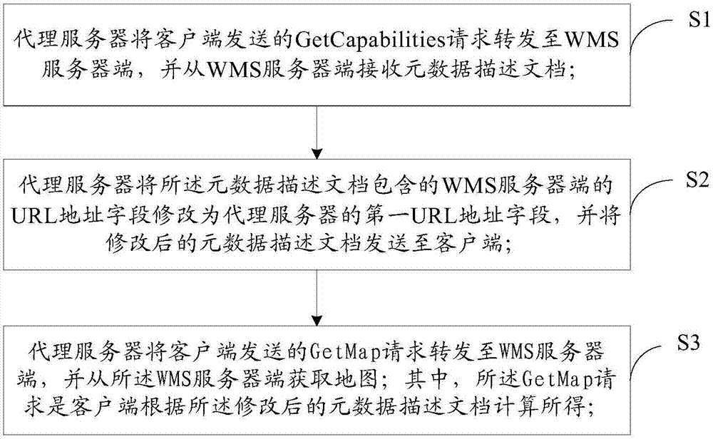
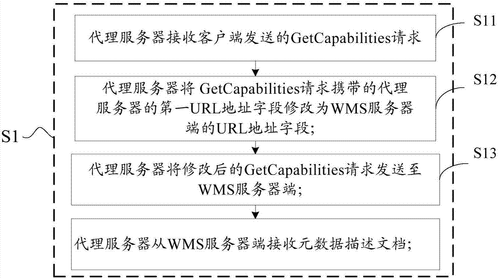
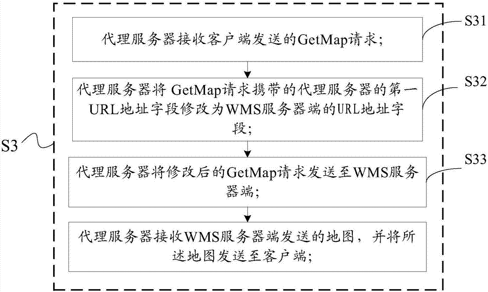
[0044] In many cases, it is necessary to proxy the Web map service from network A to network B, and then access the Web map service on network B. However, there is no effective solution on how to implement cross-network proxying Web map service in the prior art. In addition, none of the existing proxy server tools such as Apache and Wingate can meet the requirements of cross-network proxy WMS map service. In view of this, the inventors of the present invention propose a method and system for cross-network proxying of Web map services, and a proxy server for realizing cross-network proxying of Web map services.

[0045] Attached below Figure 1-4 The technical solution of the present invention is described in detail with specific examples.

[0046] figure 1 A schematic diagram of a method for cross-network proxying a Web map service according to an embodiment of the present invention is shown. Before introducing the method of cross-network proxying Web map service, the netw...


PUM


Abstract

The invention discloses an across-network agent Web map service method and system and an agent server. The method comprises the following steps: forwarding a GetCapabilities request sent by a client to a WMS (Web Mapping Service) server by the agent server, and receiving a metadata description document from the WMS server; modifying a URL address field of the WMS server included in the metadata description document into a first URL address field of the agent server by the agent server, and transmitting the modified metadata description document to the client; and forwarding a GetMap request transmitted by the client to the WMS server by the agent server, and acquiring a map from the WMS server, wherein the GetMap request is calculated by the client according to the modified metadata description document. The across-network agent Web map service method provided by the invention can realize the across-network agent Web map service through the above steps, and the method is simple and feasible and very practical.

Description

technical field [0001] The invention relates to the technical field of WMS (Web map service) access, in particular to a method, system and proxy server for cross-network agent Web map service. Background technique [0002] In the field of spatial data interoperability, the interoperability method based on the public interface access mode is a basic operation method. Through the International Organization for Standardization (such as ISO / TC211) or technical alliances (such as OGC) to formulate interface specifications for spatial data interoperability, GIS (Geographic Information System) software vendors develop spatial data read and write functions that follow this interface specification, which can be realized Interoperability of Heterogeneous Spatial Databases. OGC (Open Geospatial Consortium) defines three geographic reference information models: WMS (Web Map Service), WFS (Web Feature Service), and WCS (Web Geographic Coverage Service). [0003] WMS can return maps in ...

Claims


Application Information

Patent Timeline
Patent Type & Authority Applications(China)
IPC IPC(8): H04L29/08G06F17/30
CPCH04L67/02G06F16/29H04L67/565H04L67/51H04L67/56
Inventor 袁晓娟陈启志郭彦义葛洁王恺王燕汤希娟张彦蕾李雪莲耿悦
Owner 华北计算技术研究所
Why Eureka
Try Eureka