Coordinate measuring method and device of GPS-RTK satellite-signal-free point

A coordinate measurement and satellite signal technology, applied in the field of GPS-RTK mobile measurement devices, can solve problems such as under eaves, under trees, under steep ridges, near high-rise buildings, unable to observe key positions, weak satellite signals, etc. Quantity and signal quality, improved GPS satellite signal, low production cost effect

Inactive Publication Date: 2018-03-23
XIAN UNIV OF SCI & TECH
View PDF4 Cites 1 Cited by
  • Summary
  • Abstract
  • Description
  • Claims
  • Application Information

AI Technical Summary

Problems solved by technology

In the actual GPS-RTK mobile measurement process, due to the occlusion of terrain and ground objects, such as under the eaves, under trees, under steep slopes, near high-rise buildings, etc., the satellite signal is weak or there is no satellite signal, resulting in house corners, trees, etc. Key positions such as the position and the lower edge of the steep slope cannot be observed

Method used


Image

  • Coordinate measuring method and device of GPS-RTK satellite-signal-free point
  • Coordinate measuring method and device of GPS-RTK satellite-signal-free point
  • Coordinate measuring method and device of GPS-RTK satellite-signal-free point

Examples


Embodiment Construction

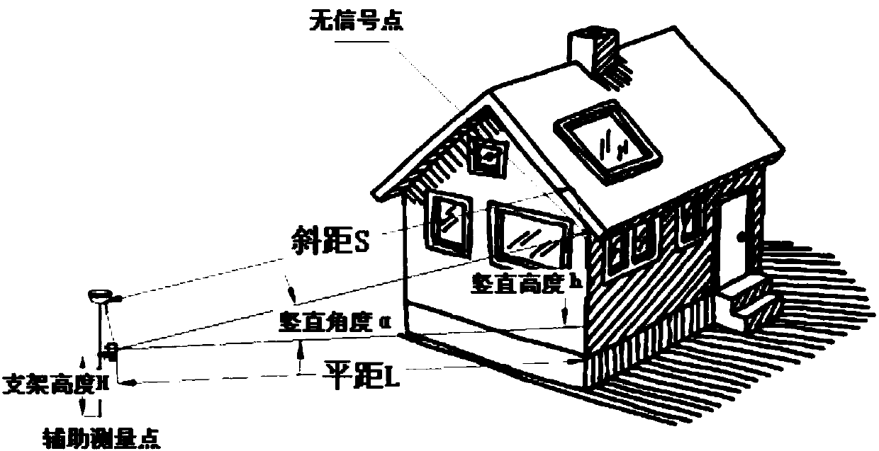
[0023] Such as figure 1 As shown, the present invention is mainly designed for the situation that the GPS satellite signal of the mobile station is interrupted, the GPS satellite signal is weak, and the current position measurement cannot be completed, and the handheld laser range finder is combined with the GPS-RTK mobile station to provide a GPS-RTK wireless Coordinate measurement method and device for satellite signal points. Install this device on the centering rod of the GPS receiver, use the laser rangefinder to quickly measure the distance between the auxiliary point and the no-signal point, and use the method of mathematical space intersection to calculate the coordinates of the no-signal point to achieve accurate measurement of the no-signal point ( Such as the corner point, the lower edge of the steep slope, the position of tall trees, etc.) The purpose of the position.

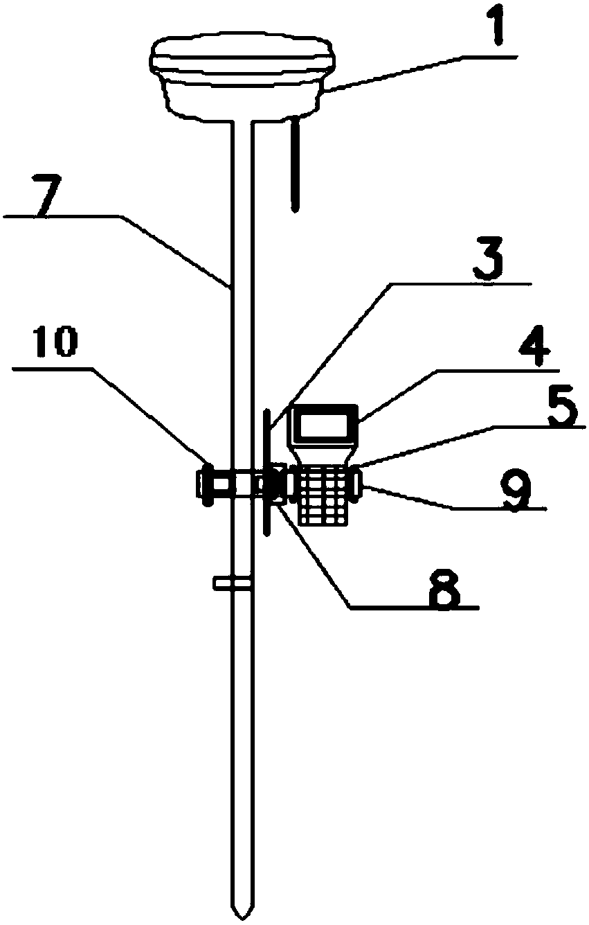
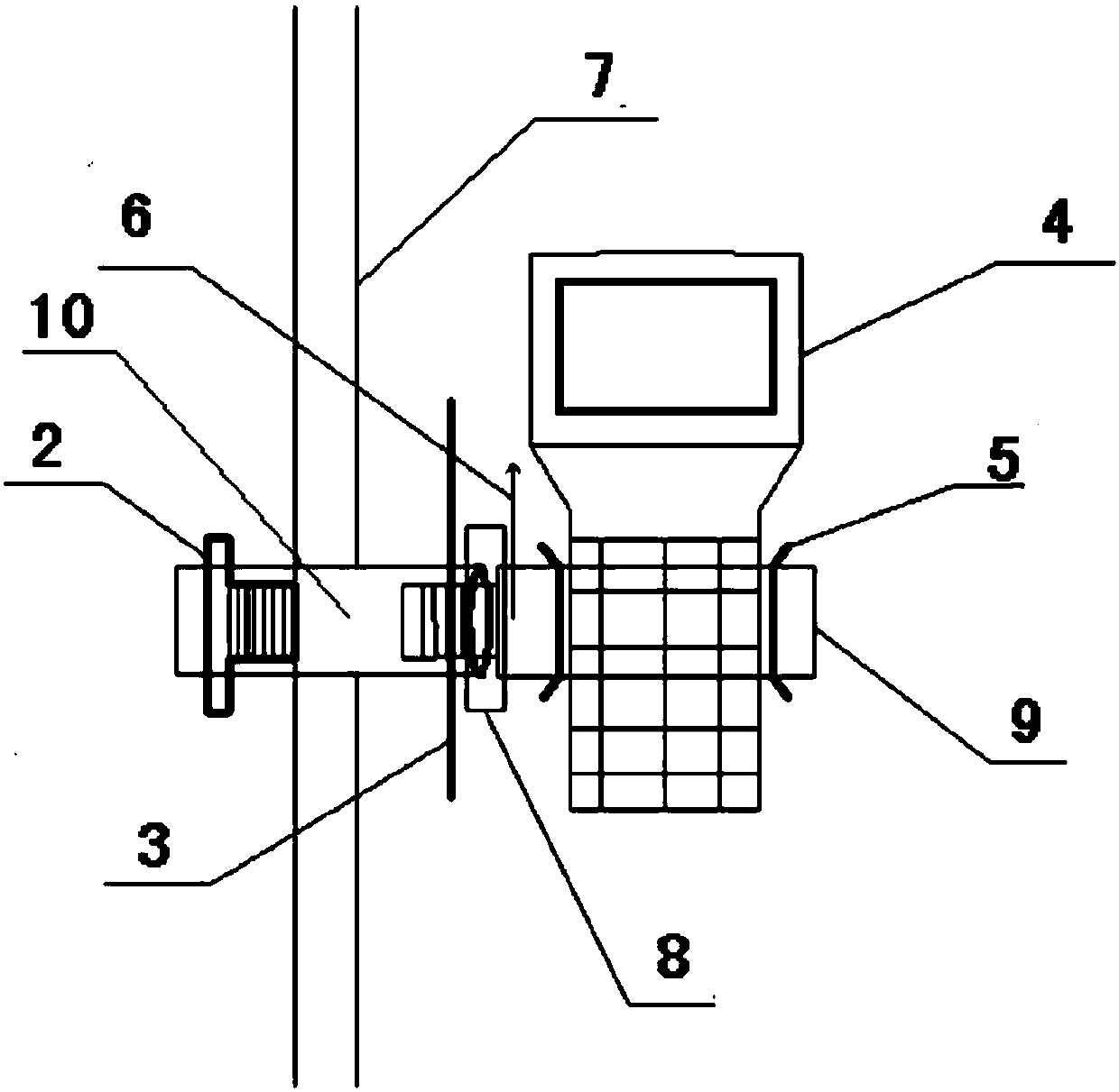
[0024] Such as figure 2 , image 3 , Figure 4 , Figure 5 As shown, a GPS-RTK coordinate...


PUM


Abstract

The invention discloses a coordinate measuring method and device of a GPS-RTK satellite-signal-free point. A GPS measuring device is combined with a laser range finder, a coordinate position of a signal-free region is calculated indirectly via a mathematic method. According to the measuring device and method, extra measuring staff is not required, instead, a work staff can complete field work measurement by implementing extra observation twice near a signal-free position, carrying out laser range finding, and recording an observation code, the measuring coordinate, and the inclined distance and the vertical angle relative to a signal-free point. In office work, the coordinate is calculated automatically according to a designed calculation method, and a practical coordinate value of the signal-free position can be obtained. The device and method improve the speed and efficiency of GPS-RTK field-work observation greatly, and the coordinate precision of the signal-free point is improved compared with other methods due to rigorous mathematical operation.

Description

technical field [0001] The invention relates to a GPS-RTK mobile measuring device and method. Background technique [0002] GPS measurement methods mainly include static, fast static, dynamic measurement, RTK (Real-time Kinematic) measurement, etc. Among them, static, fast static, and dynamic measurements need to be solved afterwards to obtain centimeter-level accuracy, while GPS-RTK Real-time differential positioning is a measurement method that can obtain centimeter-level positioning accuracy in real time in the field, which greatly improves the efficiency of field operations. GPS-RTK operation mode such as Figure 9 As shown, the reference station transmits its observation value and station coordinate information to the rover station through the data station, the rover station receives the data from the reference station, and the rover station receives the GPS satellite data at the same time, and then combines the two data for real-time differential calculation. Obtain c...

Claims


Application Information

Patent Timeline
Patent Type & Authority Applications(China)
IPC IPC(8): G01S19/48
CPCG01S19/48
Inventor 郑俊良姚顽强张咏程前进
Owner XIAN UNIV OF SCI & TECH
Why Eureka
Try Eureka