Level gauge for road surveying and mapping

A level instrument and road technology, which is applied in the field of level instruments for road surveying and mapping, can solve problems such as low accuracy, disrupting the balance of the level instrument, and inability to adjust the level instrument height.

Inactive Publication Date: 2018-08-17
SINOPOL ELECTRONICS TECH
View PDF0 Cites 4 Cited by
  • Summary
  • Abstract
  • Description
  • Claims
  • Application Information

AI Technical Summary

Problems solved by technology

[0004] Aiming at the deficiencies in the prior art, the object of the present invention is to provide a level for road surveying and mapping, to solve the problem that the height of the level cannot be adjusted when the prior art is in use, and when the ground is uneven, it is easy to disturb the height of the level. Balance, low accuracy issues

Method used


Image

  • Level gauge for road surveying and mapping
  • Level gauge for road surveying and mapping
  • Level gauge for road surveying and mapping

Examples


Embodiment Construction

[0019] In order to make the technical means, creative features, goals and effects achieved by the present invention easy to understand, the present invention will be further described below in conjunction with specific embodiments.

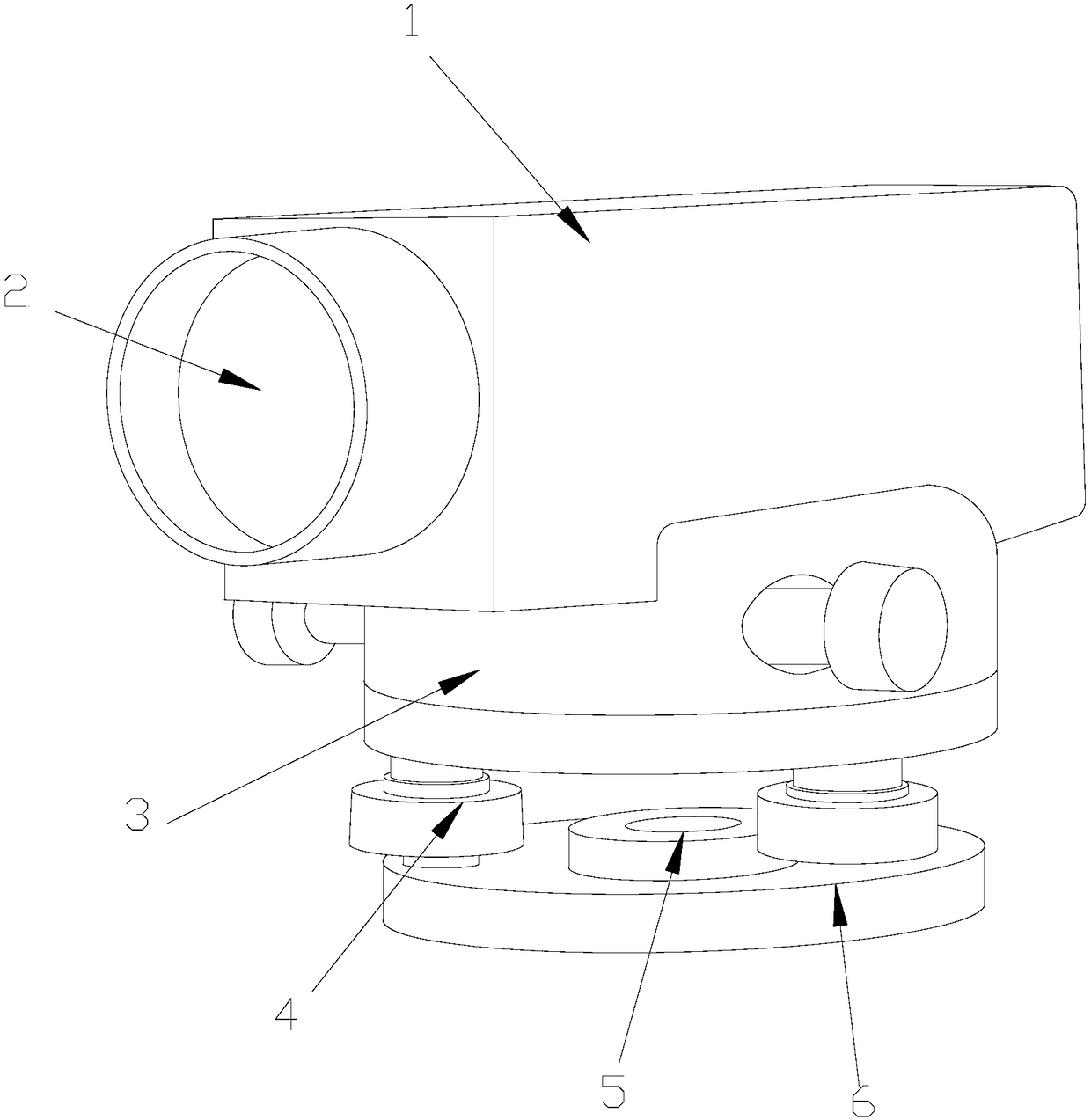
[0020] see Figure 1-Figure 5, the present invention provides a technical scheme of a level instrument for road surveying and mapping: its structure includes a test body 1, a line opening 2, a lifting and debugging device 3, a support frame 4, a central axis ring 5, and a base 6. The test body 1 The bottom is provided with a lifting and debugging device 3, which adopts interference fit. The base 6 is arranged below the lifting and debugging device 3 and is parallel to each other. The middle part adopts interference fit, and the support frame 4 is provided with two, and is located on the same plane. Shaped structure, and located in the middle of the base 6, using interference fit, the left and right ends above the base 6 are vertically connected w...


PUM


Abstract

The invention discloses a level gauge for road surveying and mapping, wherein the level gauge comprises a test machine body, a line feeding port, a lifting and debugging device, two support frames, amiddle shaft ring and a base; the lifting and debugging device is arranged below the test machine body, interference fit is adopted, and the base is arranged below the lifting and debugging device andis parallel to the lifting and debugging device; the line feeding port is of a round structure and is arranged in the middle part of the front end of the test machine boy, and interference fit is adopted; two support frames are located in a same plane and are vertically connected with the left end and the right end below the lifting and debugging device respectively; the middle shaft ring is of around structure and is located in the middle part of the base, and interference fit is adopted; the left end and the right end above the base are vertically connected with the support frames respectively. The height of the level gauge can be adjusted and adjusted smoothly when the level gauge is used; when the ground is not even, the balance of the level gauge is not easy to disturb, and the accuracy is high.

Description

technical field [0001] The invention is a level instrument for road surveying and mapping, which belongs to the field of level instruments. Background technique [0002] With the development of China's economy and the improvement of comprehensive national strength, it has driven the comprehensive and rapid development of my country's civil engineering field. In order to meet the needs of road construction and construction, the measuring equipment of the level has also been widely used. The level measuring device is mainly used to measure the position height of a certain point in engineering, or the position height difference between two points. The existing The level measuring device is usually composed of a level and two leveling staffs. The level mainly includes a base connected to the tripod, a level body rotatably connected to the base, a telescope inside the body, and a corresponding level on the body. leveling structure. [0003] When the prior art is in use, the hei...

Claims


Application Information

Patent Timeline
Patent Type & Authority Applications(China)
IPC IPC(8): G01C5/04G01C15/00
CPCG01C5/04G01C15/00
Inventor 陈永桥
Owner SINOPOL ELECTRONICS TECH
Why Eureka
Try Eureka