Global navigation satellite system ground-based augmentation position method

A global navigation satellite and ground-based enhancement technology, applied in the field of satellite navigation and positioning, to achieve high economy and practicality, and improve quality

Inactive Publication Date: 2018-11-02
全图通位置网络有限公司
View PDF6 Cites 1 Cited by
  • Summary
  • Abstract
  • Description
  • Claims
  • Application Information

AI Technical Summary

Problems solved by technology

[0009] The key technology for real-time GNSS precise positioning enhancement of the dynamic positioning carrier equipment system in a specific area of ​​the factory. Due to technical and engineering requirements, it is difficult to obtain GNSS enhanced data from other channels such as the Internet in the factory area. Therefore, the correction data can only be obtained through the network at the service center.

Method used


Image

  • Global navigation satellite system ground-based augmentation position method

Examples


Embodiment Construction

[0027] Hereinafter, embodiments of the enhanced positioning method of the present invention will be described with reference to the accompanying drawings.

[0028] The examples described here are specific specific implementations of the present invention, and are used to illustrate the concept of the present invention. They are all explanatory and exemplary, and should not be construed as limiting the implementation of the present invention and the scope of the present invention. In addition to the embodiments described here, those skilled in the art can also adopt other obvious technical solutions based on the claims of the application and the content disclosed in the description, and these technical solutions include making any obvious replacements for the embodiments described here. and modified technical solutions.

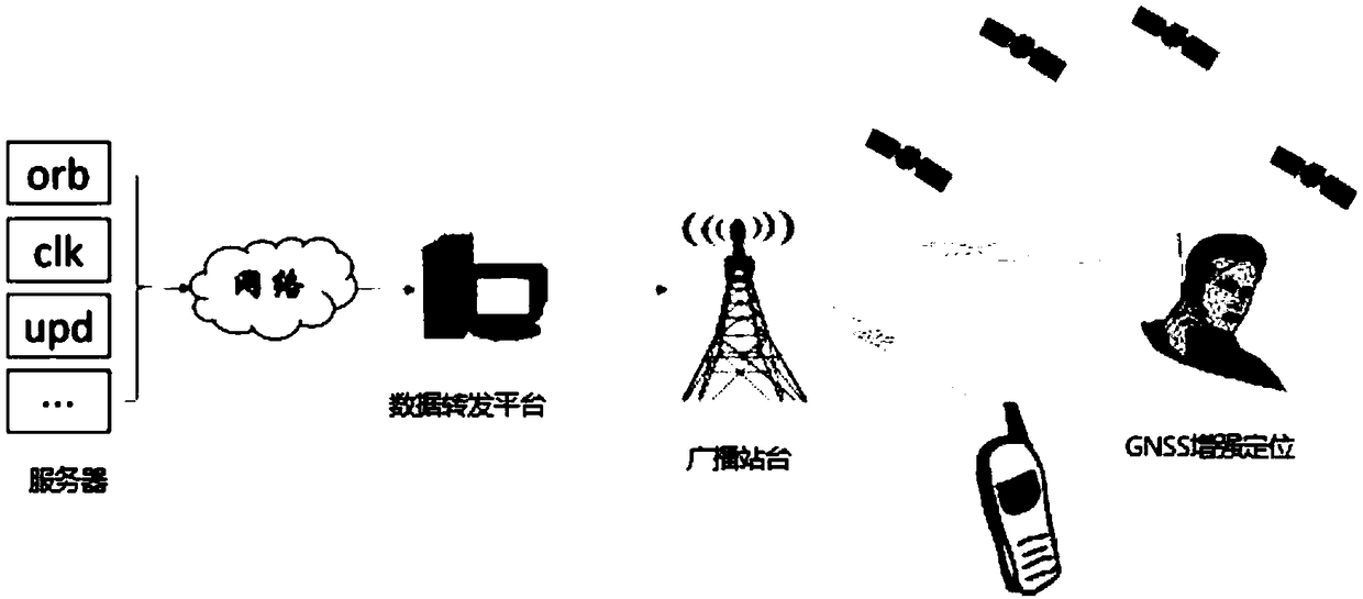
[0029] According to the technical scheme of the present invention, the PDT broadcast communication technology is used to broadcast real-time correction data t...


PUM


Abstract

The invention provides technology for performing GNSS corrected data transmission and performing area high-precision dynamic positioning on a specific area by means of a PDT (professional digital trunking) channel. The positioning method comprises the following steps of performing real-time acquisition of GNSS observation data through GNSS terminal equipment; performing real-time resolving of theGNSS corrected data by a server according to the received GNSS data flow and transmitting the resolved GNSS corrected data to a data forwarding platform; performing re-coding of the GNSS corrected data by the data forwarding platform and performing real-time transmission to the GNSS terminal equipment which comprises a decoding module and a positioning module; decoding the GNSS corrected data by the decoding module of the GNSS terminal equipment and performing transmission to the positioning module, and performing real-time augmentation resolving by the positioning module according to the received GNSS observation data and the GNSS corrected data, thereby obtaining the position information of the GNSS terminal equipment.

Description

technical field [0001] The invention belongs to the technical field of satellite navigation and positioning, and relates to a global navigation satellite system (Global Navigation Satellite System, GNSS) ground-based enhanced positioning method. Background technique [0002] Real-time GNSS precise positioning enhancement technology is mainly composed of the following five parts: 1) data acquisition part; 2) enhanced data calculation and storage part; 3) enhanced data transmission part; 4) data calculation part; 5) data visualization display part. [0003] The data acquisition part refers to the collection of satellite real-time observation data through GNSS terminal equipment; [0004] The enhanced data calculation and storage part refers to the calculation and storage of real-time GNSS data streams on the server, and real-time acquisition of correction data for enhanced positioning; [0005] The part of enhanced data transmission refers to sending real-time correction data...

Claims


Application Information

Patent Timeline
IPC IPC(8): G01S19/40
CPCG01S19/40
Inventor 蔺陆洲张迪马长斗徐天河孙张振
Owner 全图通位置网络有限公司
Why Eureka
Try Eureka