Satellite navigation system-based gridded accurate positioning service method and system

A satellite navigation system and precise positioning technology, which is applied in the field of grid-based precise positioning services, can solve problems such as the limited carrying capacity of users of precise positioning services, and achieve the goal of solving the expansion of service scope, overcoming the consumption of computing resources, and overcoming the defects of investment costs Effect

Active Publication Date: 2019-08-06
BEIJING CNTEN SMART TECH CO LTD
View PDF5 Cites 19 Cited by
  • Summary
  • Abstract
  • Description
  • Claims
  • Application Information

AI Technical Summary

Problems solved by technology

[0009] In view of the above problems, the embodiments of the present invention provide a grid-based precise positioning service method and system based on a satellite navigation system to solve the technical problem that existing precise positioning services are limited by hardware resources and user carrying capacity is limited

Method used


Image

  • Satellite navigation system-based gridded accurate positioning service method and system
  • Satellite navigation system-based gridded accurate positioning service method and system
  • Satellite navigation system-based gridded accurate positioning service method and system

Examples


Embodiment Construction

[0076] In order to make the purpose, technical solution and advantages of the present invention clearer and clearer, the present invention will be further described below in conjunction with the accompanying drawings and specific embodiments. Apparently, the described embodiments are only some of the embodiments of the present invention, but not all of them. Based on the embodiments of the present invention, all other embodiments obtained by persons of ordinary skill in the art without creative efforts fall within the protection scope of the present invention.

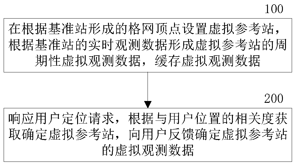
[0077] A grid-based precise positioning service method based on a satellite navigation system in an embodiment of the present invention is as follows: figure 1 shown in figure 1 , this example includes:

[0078] Step 100: Set up a virtual reference station at the vertex of the grid formed by the reference station, form periodic virtual observation data of the virtual reference station according to the real-time obser...


PUM


Abstract

The invention provides a satellite navigation system-based gridded accurate positioning service method and system. With the satellite navigation system-based gridded accurate positioning service method and system adopted, the technical problem of limited user carrying capacity which is caused by a condition that existing accurate positioning services are limited by hardware resources can be solved. The method includes the following steps that: virtual reference stations are set according to grid vertexes formed by a reference station, and the periodic virtual observation data of the virtual reference stations are formed according to the real-time observation data of the reference station, and the virtual observation data are cached; and a user positioning request is responded, a determinedvirtual reference station is obtained according to relevancy between the virtual reference stations and a user position, and the virtual observation data of the determined virtual reference station are fed back to a user. According to the method and system of the invention, the continuous virtual observation data of all the virtual reference stations are actively formed in a precise positioning area through dynamic gridding so as to form unified differential information resources in a service area; and therefore, a user response process in the prior art is improved, the network gridding dynamic update calculation of the VRS (Virtual Reference Station) is realized; and the calculation capacity of a platform is optimized to the greatest extent.

Description

technical field [0001] The invention relates to the technical field of satellite positioning, in particular to a grid-based precise positioning service method and system based on a satellite navigation system. Background technique [0002] In the prior art, network RTK (Real-time kinematic, real-time dynamic carrier phase difference) technology is usually used in order to provide real-time and reliable precise location services. The network RTK technology includes reference stations, data service platforms and user RTK terminals. Each reference station transmits the observation data of navigation satellites to the data service platform through communication links. The data service platform centrally processes the real-time observation data of each reference station. Real-time Estimate various error items within the distribution range of the reference station, perform unified error modeling, generate network RTK service data, and distribute the corresponding network RTK servi...

Claims


Application Information

Patent Timeline
Patent Type & Authority Applications(China)
IPC IPC(8): G01S19/44
CPCG01S19/44
Inventor 滑中豪李宁吴东东余博尧
Owner BEIJING CNTEN SMART TECH CO LTD
Why Eureka
Try Eureka