Method for estimating land surface termperature lapse rate using infrared image

a technology of infrared image and lapse rate, which is applied in the field of estimating the lapse rate of land surface temperature using infrared image, can solve the problems of inability to supply power, sudden heavy rain, heavy snow or fog, and poor weather, so as to minimize the atmospheric effects of infrared imag

Active Publication Date: 2016-04-07
UNIV OF SEOUL IND COOP FOUND
View PDF12 Cites 12 Cited by
  • Summary
  • Abstract
  • Description
  • Claims
  • Application Information

AI Technical Summary

Benefits of technology

[0017]The calculating atmospheric transmittance may be perfor

Problems solved by technology

In general, in an alpine area, bad weather, such as sudden heavy rain, heavy snow or a thick fog, may occur unexpectedly due to a drastic change in temperature, unlike in a low-elevation area.
When a person who does not have basic knowledge about an alpine area is located in an alpine area at night, he or she has the possibility of experiencing an accident due to sudden bad weather.
In an alpine area, a suddenly frozen road may be a cause of a traffic accident.
Automatic meteorological observation devices capable of collecting temperature data are intensively distributed in a populated area and are rare in a mountainous area, and have been used for short-term observation over the course of 1 to 2 years because the automatic meteorological observation devices may be easily damaged by wind, heavy rain and heavy snow prominent in an alpine area an

Method used


Image

  • Method for estimating land surface termperature lapse rate using infrared image
  • Method for estimating land surface termperature lapse rate using infrared image
  • Method for estimating land surface termperature lapse rate using infrared image

Examples


Embodiment Construction

[0029]The terms and words used in the following specification and the attached claims should be interpreted as having meanings and concepts in conformity with the technical spirit of the present invention based on the principle that an inventor may appropriately define the concepts of terms and words in order to describe his or her invention in the best way.

[0030]Throughout the specification and the claims, unless explicitly described to the contrary, the terms “include” and “comprise” and their variants, such as “includes,”“including,”“comprises” and “comprising,” will be understood to imply the inclusion of stated components, not the exclusion of any other components. Furthermore, the term “ . . . unit” used in the following specification and the attached claims refers to a unit for processing at least one function or operation, and may be implemented using hardware, software or a combination of hardware and software.

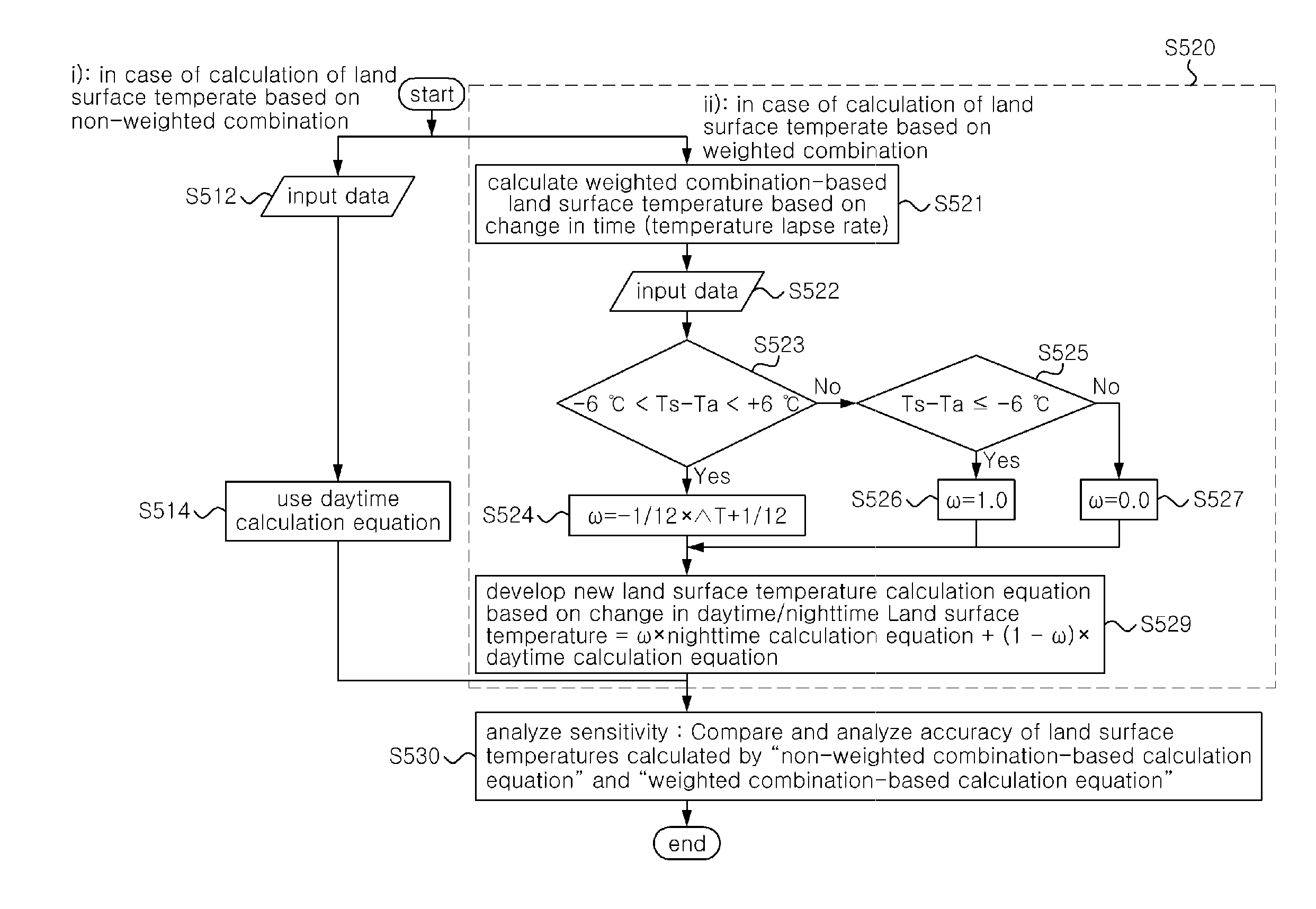
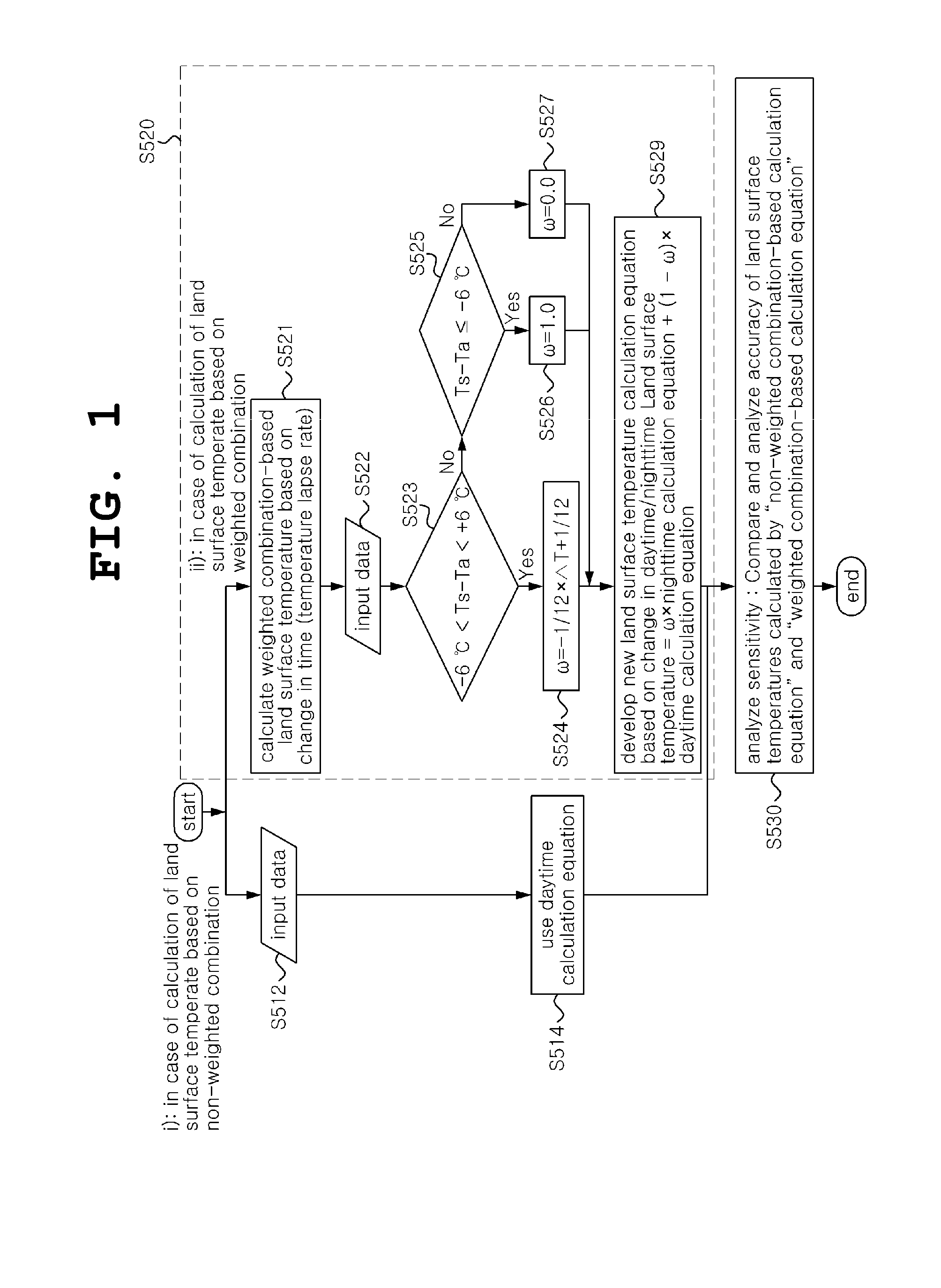
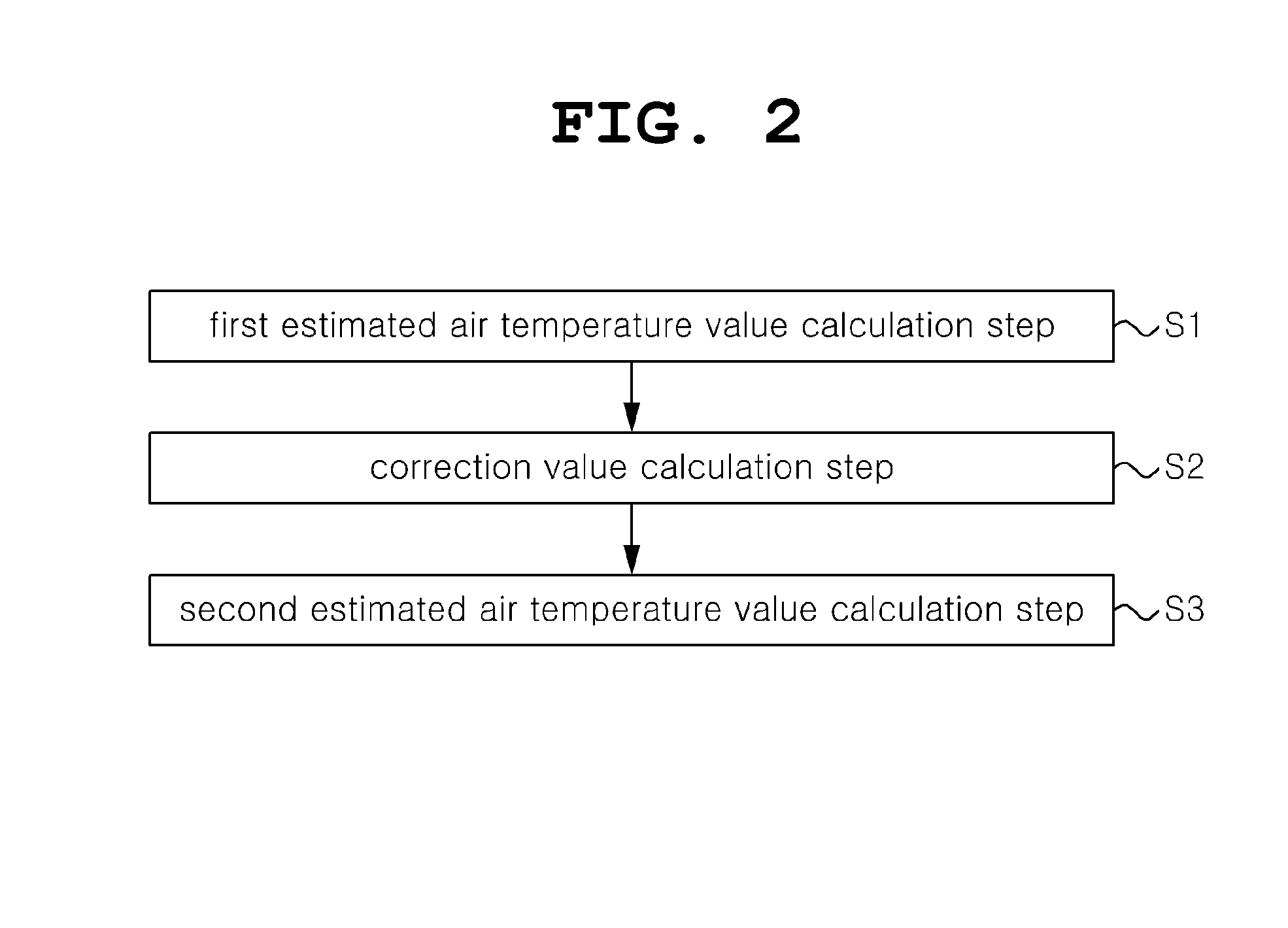
[0031]The configuration of a method of estimating land surface t...


PUM


Abstract

A method of estimating land surface temperature lapse rate using an infrared image is disclosed. In the method of estimating land surface temperature lapse rate using an infrared image, a target area for the estimation of land surface temperature lapse rate is selected. The atmospheric transmittance of the target area is calculated. Reference temperature is estimated at a reference location set in the target area as desired. A temperature difference is calculated from the atmospheric transmittance and the estimated reference temperature, and then a temperature difference image is generated. Land surface temperature lapse rate is estimated from the temperature difference image and a Digital Elevation Map (DEM) in an identical area using an elevation-based temperature difference distribution.

Description

CROSS-REFERENCE TO RELATED APPLICATION[0001]This application is a continuation of PCT / KR2014 / 005113 filed on Jun. 11, 2014, which claims priority to Korean Application No. 10-2013-0066727 filed on Jun. 11, 2013, which application is incorporated herein by reference.TECHNICAL FIELD[0002]The present invention relates generally to a method of estimating land surface temperature lapse rate using an infrared image and, more particularly, to a method of estimating land surface temperature lapse rate using an infrared image, which is capable of estimating land surface temperature lapse rate without automatic meteorological observation equipment.[0003]The present invention has been derived from research carried out as part of the Core Space Technology Development Project that has been sponsored by the Korean Ministry of Education, Science and Technology and the National Research Foundation of Korea [Project Management Number: 1345178484; Project Title: Development of Technique for Extractin...

Claims


Application Information

Patent Timeline
IPC IPC(8): G01J5/00G01J5/02G01W1/00
CPCG01J5/007G01J2005/0077G01J5/02G01W1/00G01J5/025G01J5/026
Inventor JUNG, HYUNG SUPPARK, SUNG HWAN
Owner UNIV OF SEOUL IND COOP FOUND
Why Eureka
Try Eureka