System and method for detecting small burning spots of forest or grassland fires by using environmental minisatellite HJ

A satellite and fire point technology, applied in the field of forest or grassland fire remote sensing monitoring

Inactive Publication Date: 2011-09-21
BEIJING NORMAL UNIVERSITY
View PDF2 Cites 34 Cited by
  • Summary
  • Abstract
  • Description
  • Claims
  • Application Information

AI Technical Summary

Problems solved by technology

However, so far, the monitoring of forest fires using the environmental small satellite HJ is mainly based on the traditional method of visual

Method used


Image

  • System and method for detecting small burning spots of forest or grassland fires by using environmental minisatellite HJ
  • System and method for detecting small burning spots of forest or grassland fires by using environmental minisatellite HJ
  • System and method for detecting small burning spots of forest or grassland fires by using environmental minisatellite HJ

Examples


Embodiment Construction

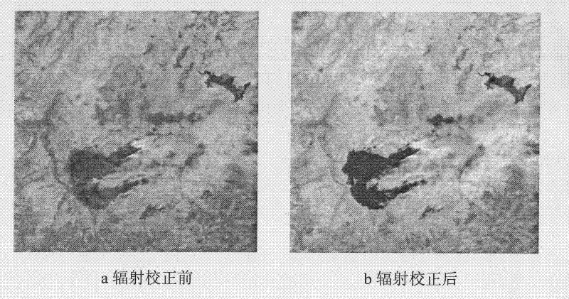
[0070] The implementation example of the present invention is selected as the IRS image of the forest fire environment small satellite HJ in the Zhanhe area of ​​Heilongjiang, China that occurred on April 29, 2009.

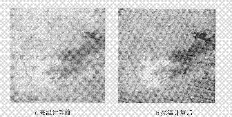
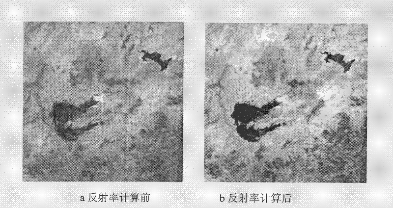
[0071] 1. System flow

[0072] A. Radiation correction:

[0073] It is used to transform and correct the gray value (DN) of the environmental small satellite HJ infrared (IRS) image into a physically meaningful radiance value (unit: W m -2 ·sr -1 . ).

[0074] B. Brightness temperature calculation:

[0075] The brightness temperatures T4 and T11 of the IRS bands 3 and 4 used to calculate the environmental small satellite HJ.

[0076] C. Calculation of reflectivity:

[0077] Infrared IRS band 1 and band 2 reflectance ρ for calculation of environmental small satellite HJ 1 and ρ 2 .

[0078] D. Cloud and water identification:

[0079] Used to identify clouds and water bodies and generate masks for clouds and water bodies.

[0080] The water body judgment ...


PUM


Abstract

The invention relates to a system and method for carrying out automatic detection on small burning spots of forest or grassland fires by using the infrared (IRS) data of an environmental minisatellite HJ. The method comprises the following steps: radiometric correction, brightness temperature calculation, reflectivity calculation, cloud and water recognition, potential burning spot determination,absolute burning spot determination, background characteristic analysis, relative burning spot determination, burning spot confidence, and detecting burning spot output. According to the scheme provided by the invention, based on the characteristics of the environmental minisatellite HJ, the automatic detection on forest or grassland fires can be realized only by using the infrared (IRS) data, thereby enhancing the disaster prevention and reduction capacities of domestically-produced satellites in China, and promoting the industrialized application process of domestically-produced satellites.

Description

technical field [0001] The invention relates to the field of forest or grassland fire remote sensing monitoring, in particular to a forest (grassland) fire small fire point detection system and method based on environmental small satellite HJ data, which is used for automatic fire point detection of environmental small satellite HJ. Background technique [0002] The use of remote sensing technology to monitor forest fires began in the early 1960s, when aerial infrared detectors were used. With the development of aerospace technology and remote sensing application technology, experiments and research on forest fire detection using satellite data such as NOAA-AVHRR, TM, and Defense Satellite (DMSP) have been carried out successively. Since the successful launch of the Terra satellite, MODIS data has been widely used in forest fire prevention and daily monitoring of global fires (Justice C O, Giglio L, Kaufman Y, et al. The MODIS fire products[J]. Remote Sensing of Environment,...

Claims


Application Information

Patent Timeline
IPC IPC(8): G01S17/89G01S7/48G06K9/00G01J5/60
Inventor 李京彭光雄宫阿都陈云浩
Owner BEIJING NORMAL UNIVERSITY
Why Eureka
Try Eureka