Optical remote sensing satellite data obtaining method

An optical remote sensing and data technology, applied in the field of remote sensing satellites, can solve the problems of reducing the use value of image data, unclear and invisible ground objects, etc.

Inactive Publication Date: 2013-11-27
SATELLITE SURVEYING & MAPPING APPL CENTSASMAC NAT ADMINISTATION OF SURVEYING MAPPING & GEOINFORMATION OF CHINANASG
View PDF5 Cites 8 Cited by
  • Summary
  • Abstract
  • Description
  • Claims
  • Application Information

AI Technical Summary

Problems solved by technology

[0003] The image data captured by optical remote sensing satellites is seriously affected by the weather. In bad weather conditions, the image data captured by optical remote sensing satellites may be obscured or invisible due to cloud coverage. Reduce the utilization value of image data, so tha

Method used


Image

  • Optical remote sensing satellite data obtaining method

Examples


Embodiment Construction

[0016] The present invention will be described in further detail below through specific implementation examples and in conjunction with the accompanying drawings.

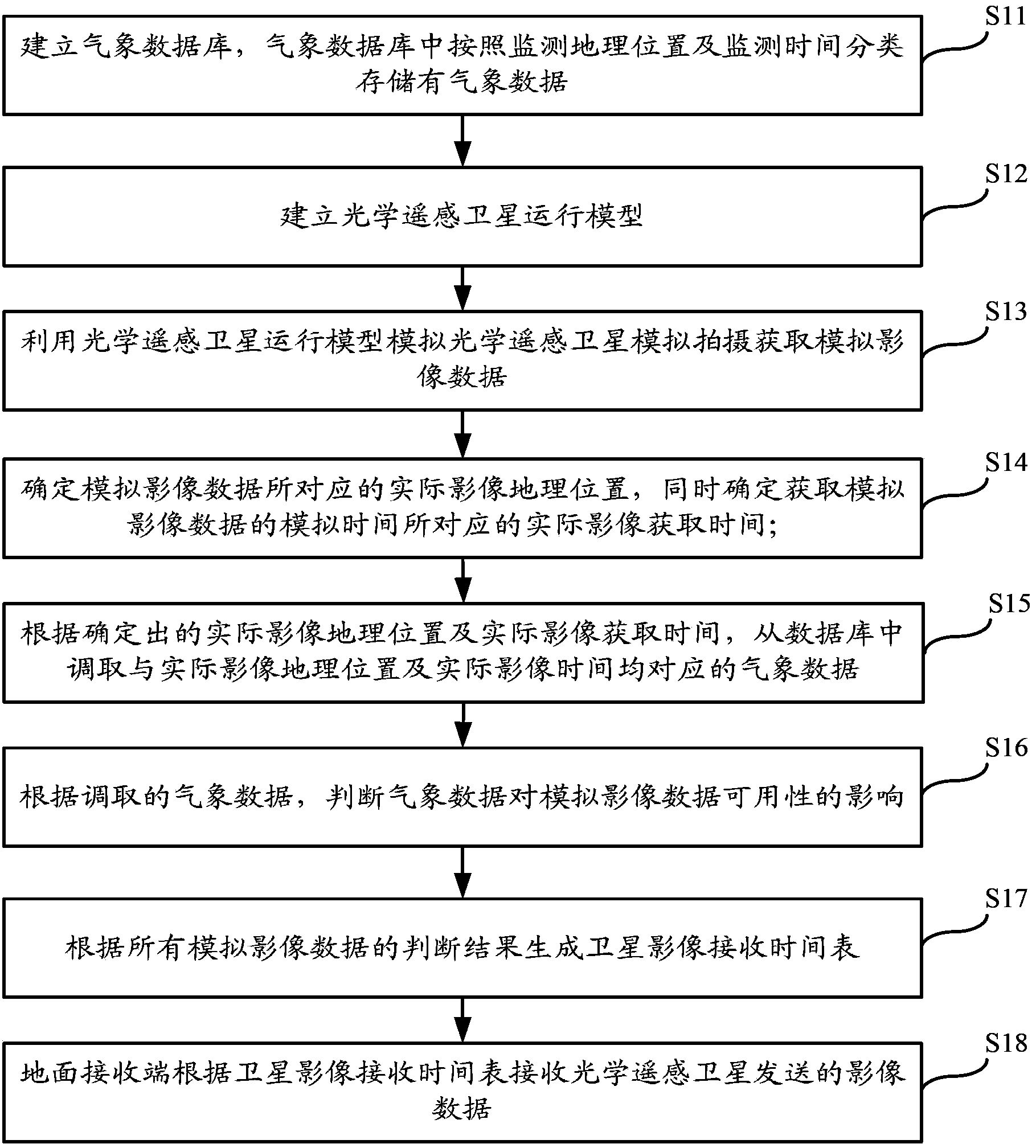
[0017] An embodiment of the present invention provides a method for acquiring optical remote sensing satellite data, such as figure 1 As shown, the main processing steps include:

[0018] Step S11: Establish a meteorological database, in which meteorological data are classified and stored according to the monitoring geographic location and monitoring time;

[0019] Step S12: Establish an optical remote sensing satellite operation model;

[0020] Step S13: Using the optical remote sensing satellite operation model to simulate the optical remote sensing satellite to simulate shooting and obtain simulated image data;

[0021] In particular, use the optical remote sensing satellite operation model to simulate the shooting time series of optical remote sensing satellites to obtain simulated image data

[0022] Step S...


PUM


Abstract

The invention relates to the technical field of remote sensing satellites, and relates to an optical remote sensing satellite data obtaining method. The method comprises the following steps of establishing a weather database, wherein weather data is classified and stored in the weather database according to monitoring geological locations and monitoring time; establishing an optical remote sensing satellite running model; utilizing the optical remote sensing satellite running model to simulate and shoot up to obtain simulation image data; determining an actual image geological location and actual image obtaining time corresponding to the simulation image data; according to the actual image geological location and the actual image obtaining time, calling the corresponding weather data from the database; according to the called weather data, judging the influence of the weather data on the availability of the simulation image data; according to the judging result of all simulation image data, generating a satellite image receiving schedule; and enabling a ground receiving terminal to receive the image data sent from the optical remote sensing satellite according to the satellite image receiving schedule. The method has the advantage that the image data received by the ground receiving terminal is available.

Description

technical field [0001] The invention relates to the technical field of remote sensing satellites, in particular to an optical remote sensing satellite data acquisition method. Background technique [0002] In related technologies, the method for obtaining data by an optical remote sensing satellite is that the optical remote sensing satellite captures and obtains image data during orbital operation, and sends the captured image data to a ground receiving end. [0003] The image data captured by optical remote sensing satellites is seriously affected by the weather. In bad weather conditions, the image data captured by optical remote sensing satellites may be obscured or invisible due to cloud coverage. The use value of image data is reduced, so that the acquired image data does not meet the use requirements, and the ground receiving end cannot prejudge whether the data transmitted by the optical remote sensing satellite meets the use requirements, and can only passively rece...

Claims


Application Information

Patent Timeline
IPC IPC(8): G06F17/30
CPCY02A90/10
Inventor 徐畅雷兵胡轶之高崟张晓韩晓彤
Owner SATELLITE SURVEYING & MAPPING APPL CENTSASMAC NAT ADMINISTATION OF SURVEYING MAPPING & GEOINFORMATION OF CHINANASG
Why Eureka
Try Eureka