Risk analyzing and processing method based on GIS

An analysis, processing, and dangerous technology, applied in data processing applications, electrical digital data processing, special data processing applications, etc. Event risk analysis and decision-making requirements for emergency response capabilities, and low level of intelligence in major public emergencies analysis, to achieve the effect of highly intelligent proposed deployment plans

Inactive Publication Date: 2016-06-01
HEBEI FAREAST COMM SYST ENG
View PDF1 Cites 8 Cited by
  • Summary
  • Abstract
  • Description
  • Claims
  • Application Information

AI Technical Summary

Problems solved by technology

[0003] With the construction of urban informatization, population data, evacuation areas, important targets, and rescue forces continue to increase, and the corresponding amount of information increases exponentially. The information on emergency response to public emergencies is complex and changeable. Due to the characteristics of suddenness, complexity, destructiveness and persistence, the analysis of major public emergencies is not intelligent enough
Based on the above situation, information collection and analysis of dangerous disasters, on-site environment and rescue forces, selection and judgment of important protected targets, damage analysis of important targets and secondary disaster analysis, population evacuation area analysis and rescue force deployment analysis more and more complicated
The traditional management information system still only stays on the functions of input, query, statistics, report printing and other functions based on the database, and it is difficult to meet the risk analysis and emergency decision-making needs of major public emergencies

Method used


Image

  • Risk analyzing and processing method based on GIS
  • Risk analyzing and processing method based on GIS
  • Risk analyzing and processing method based on GIS

Examples


Embodiment Construction

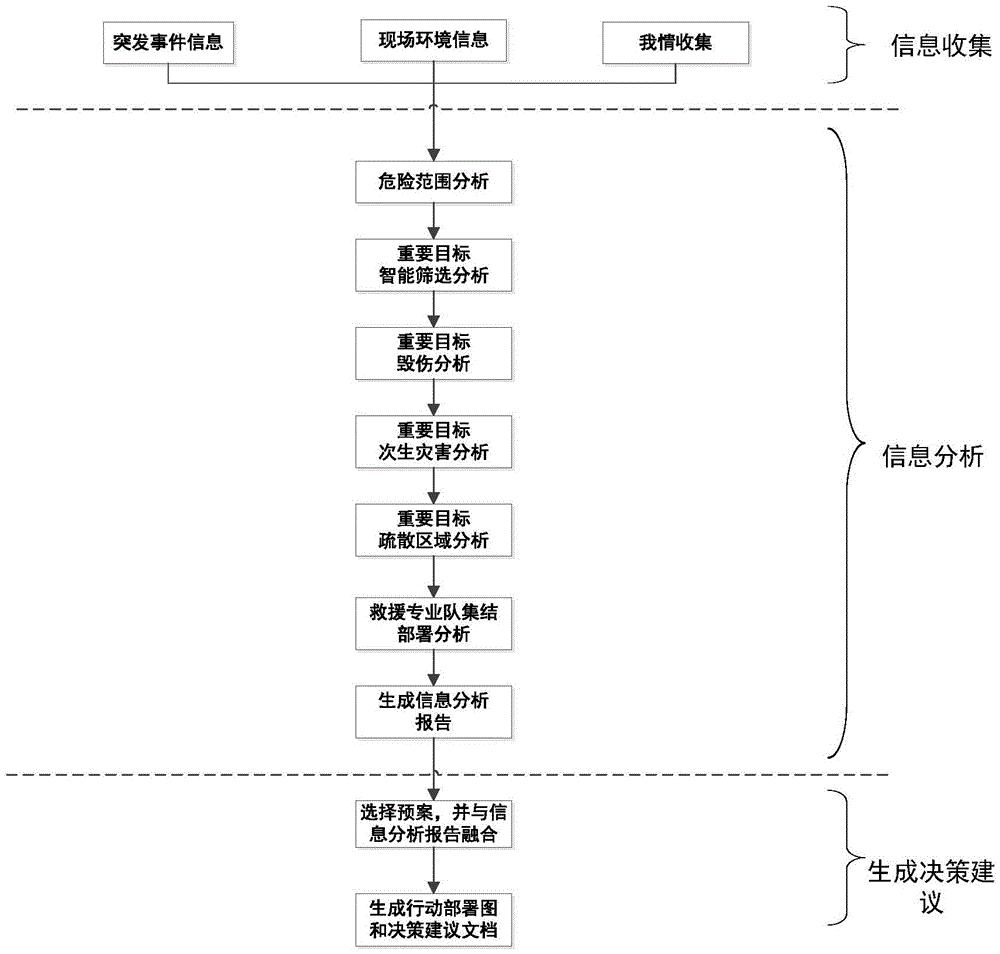
[0027] Combine below Figure 1 to Figure 7 The present invention is further described.

[0028] A method for risk analysis and processing based on GIS, comprising the following steps:

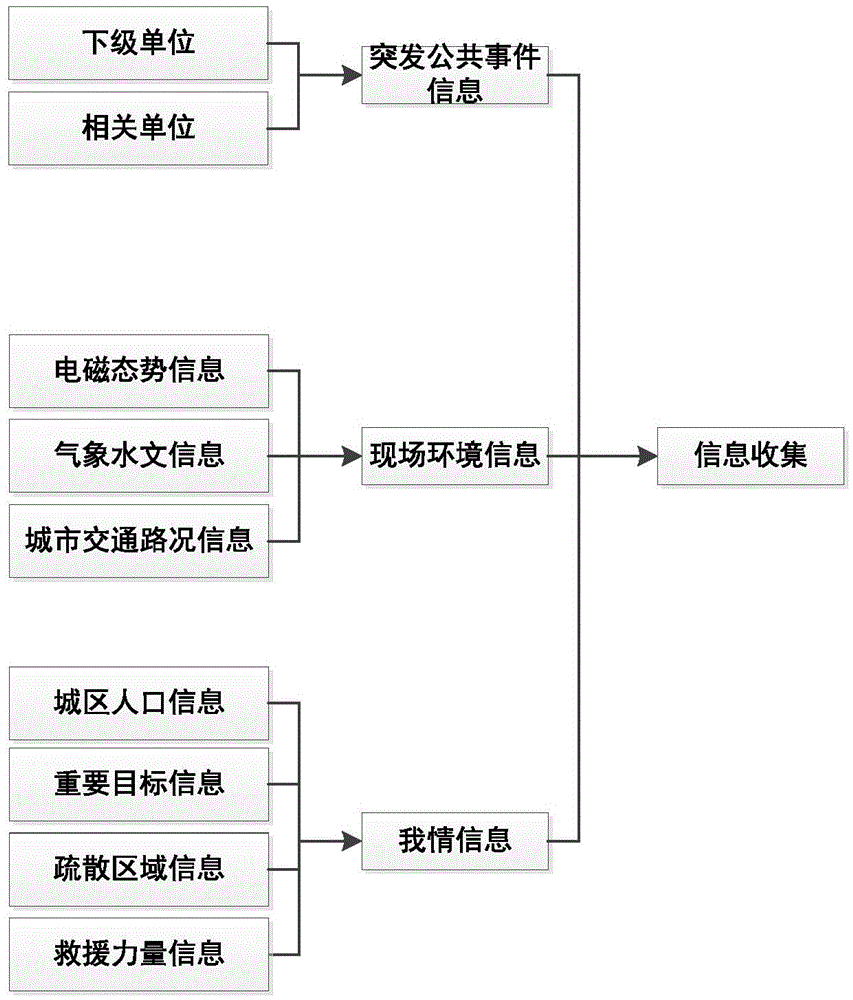
[0029] S1: The information collection system collects information, which includes emergency information, on-site environmental information and personal information;

[0030] refer to figure 2 , the information collection system collects and collects emergency information, on-site environmental information and personal information respectively, combined with image 3 , Figure 4 and Figure 5 The process of collecting the three types of information is explained respectively.

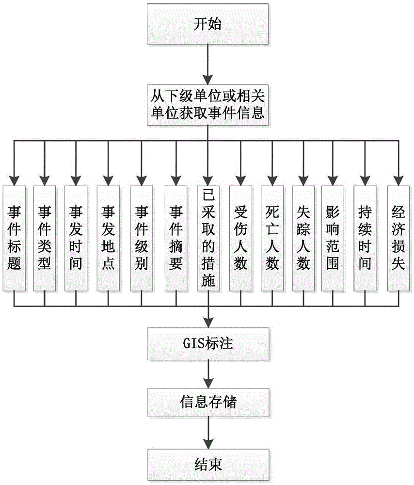
[0031] The emergency event information collection process is: Obtain event information from subordinate units or related units: mainly including event title, event type, time of incident, location of incident, level of incident, summary of incident, measures taken, number of injured, and number of deaths , the numbe...


PUM


Abstract

The present invention discloses a risk analyzing and processing method based on a GIS. According to the method, an information collection system can be used to collect emergency information, field environmental information and our condition information, through information processing, a field situation map is rapidly and automatically plotted in the GIS, and the danger range influenced by an emergency event is determined. Combined with field electromagnetic situation information, meteorological and hydrological information, urban traffic condition information, and urban population information, through important goal intelligent screening, important goal damage analysis, important goal secondary disaster analysis, important goal evacuation region analysis and rescue team assembly deployment analysis, an emergency rescue decision suggestion report and an emergency rescue integrated situation map are generated visually, and a decision support is provided for a command authority to analyze and judge a situation, make up minds and command in real time.

Description

technical field [0001] The invention belongs to the field of emergency decision-making for public emergencies, and in particular relates to decision-making suggestions for risk analysis and emergency capability analysis of major public emergencies. Background technique [0002] With the development of urbanization and industrialization, the dense flow of people and goods, and major public emergencies have brought huge losses to human beings. How to maximize the rapid response and effective control of emergencies has become an important issue for countries in the world today. issues of great concern to the government. [0003] With the construction of urban informatization, population data, evacuation areas, important targets, and rescue forces continue to increase, and the corresponding amount of information increases exponentially. The information on emergency response to public emergencies is complex and changeable. Due to the characteristics of suddenness, complexity, de...

Claims


Application Information

Patent Timeline
IPC IPC(8): G06Q10/06G06F17/30
CPCG06F16/29G06Q10/0635Y02A90/10
Inventor 郝志刚焦立彬韩志永臧艳军吴戈祝胜强齐幸辉孙安宅侯位昭周冰倪洪印郑庆红张建中王金辉
Owner HEBEI FAREAST COMM SYST ENG
Why Eureka
Try Eureka