Method for identifying mountain front deep part construction layer through utilizing gravity interface inversion

A piedmont and structural layer technology, applied in the field of oil and gas exploration, can solve problems such as complex structures, difficult horizon tracking, unclear reflection interfaces, etc., and achieve high reliability results

Active Publication Date: 2018-03-02
CHINA PETROLEUM & CHEM CORP +1
View PDF5 Cites 11 Cited by
  • Summary
  • Abstract
  • Description
  • Claims
  • Application Information

AI Technical Summary

Problems solved by technology

However, there are many difficulties in the interpretation of seismic data in the process of target exploration in the periphery of the Junggar Basin, especially in the complex structural belt in the piedmont. The main reason is that the seismic geological conditions are poor and the structure is complex, which leads to weak seismic reflection signals in deep layers and unclear reflection interfaces. In addition, there are few exploratory wells in some areas, and it is difficult to carry out effective well location calibration, resulting in difficulty in layer tracking, inaccurate interpretation of structures and interfaces, and unclear understanding of deep structural attributes, which cannot meet the needs of exploration research, affecting basin target selection and risks. Well Evaluation Deployment
There are currently no reports on the above studies

Method used


Image

  • Method for identifying mountain front deep part construction layer through utilizing gravity interface inversion
  • Method for identifying mountain front deep part construction layer through utilizing gravity interface inversion
  • Method for identifying mountain front deep part construction layer through utilizing gravity interface inversion

Examples


Embodiment Construction

[0028] The detailed description and technical content of the present invention are described below in conjunction with the accompanying drawings. However, the accompanying drawings are only provided for reference and description, and are not used to limit the present invention.

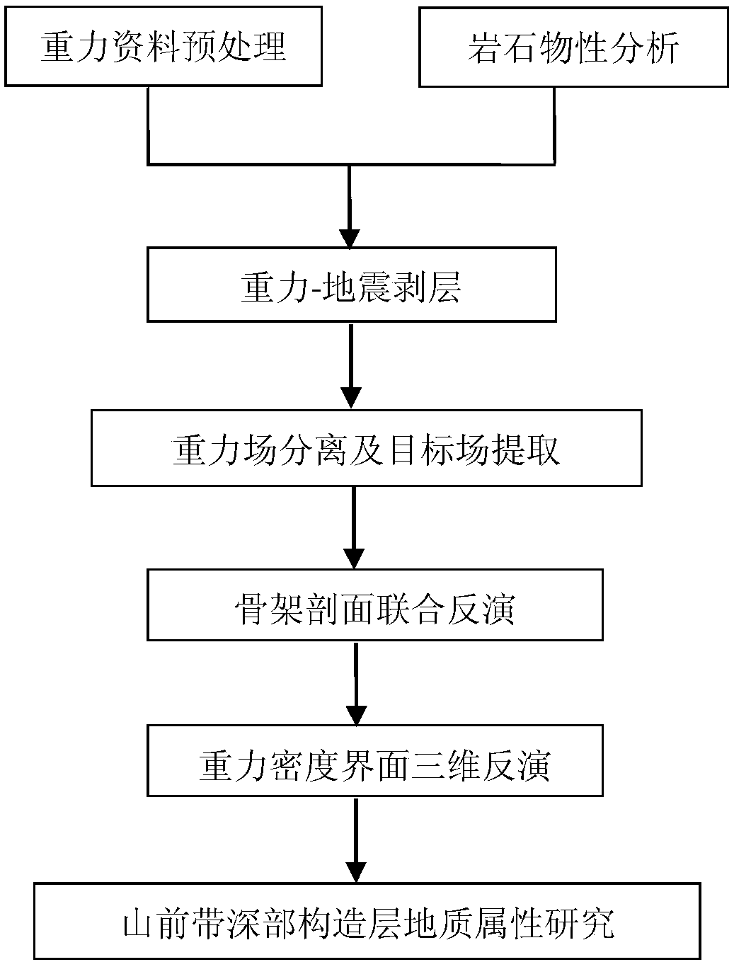
[0029] figure 1 It is a schematic flow chart of the method for identifying deep structural layers in the piedmont zone using gravity interface inversion in the present invention, such as figure 1 As shown, the method includes the following steps:

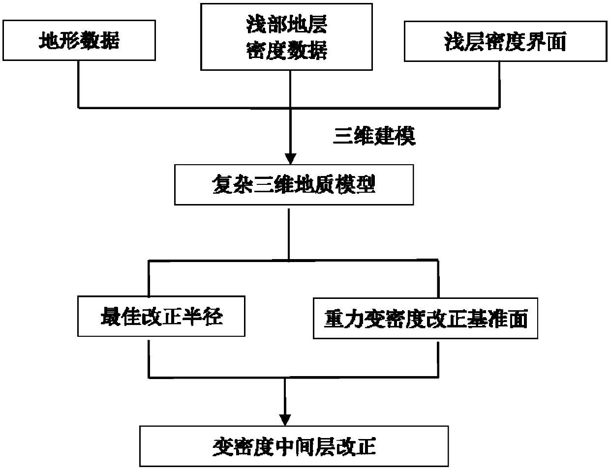
[0030] The first step is to pre-process the gravity data to eliminate the mountain-shaped influence, and suppress and eliminate surface and shallow interference. In this case, the MC1 well area is taken as an example. Considering that the abrupt change of terrain will cause the gravity anomaly to have a strong correlation with the terrain, the terrain impact must be corrected. The specific flow chart is figure 2 Shown. Due to the large terrain elevation span of...


PUM


Abstract

The invention provides a method for identifying a mountain front deep part construction layer through utilizing gravity interface inversion and is a gravity density interface inversion method for difficulty in depicting deep part stratum structure attributes during mountain front oil gas target exploration. The method comprises steps that gravity potential field data pre-processing is carried outto form basic data before data inversion; different target area lithology and stratum physical property rules are analyzed, and physical property base of density interface inversion is made to be clear; a variable density physical property model is established, and an inversion physical property model is provided; gravity-earthquake combined step by step fine delamination is carried out, and superposition field source separation precision is enhanced; drilling well-earthquake constraints are added to the space domain, and interface constraints are provided by skeleton profile combined inversion; gravity density interface three-dimensional inversion is developed, and the geological structure attributes of the mountain front deep part construction layer is made to be clear. The method is advantaged in that distribution characteristics of the mountain front deep part construction layer is effectively depicted, geological basis is provided for mountain front deep oil gas exploration, andoil gas exploration risks are reduced.

Description

Technical field [0001] The invention relates to the technical field of processing, inversion and comprehensive geological interpretation of geophysical data in the field of oil and gas exploration, in particular to a method for identifying the geological attributes of deep structural layers in piedmont zones based on gravity density interface inversion. Background technique [0002] The Junggar Basin is the main position for oil and gas exploration in western China. With the increase in exploration and research, especially the discovery of the Kelamei gas field in the Junggar Basin and the Niudong oil and gas field in the Santanghu Basin, the Carboniferous in northern Xinjiang has become an important hydrocarbon-bearing strata. , Is a new area of ​​regional oil and gas exploration, with great strategic significance. However, there are many difficulties in the interpretation of seismic data in the process of target exploration in the periphery of the Junggar Basin, especially in t...

Claims


Application Information

Patent Timeline
Patent Type & Authority Applications(China)
IPC IPC(8): G01V11/00
CPCG01V11/00
Inventor 郭涛陈学国冯国志胡加山谭绍泉林会喜王有涛相鹏于会臻李竹强林治模魏敏吴微唐付良郝志伟张建华杨国杰王月蕾时秀朋钱焕菊
Owner CHINA PETROLEUM & CHEM CORP
Why Eureka
Try Eureka