User-defined range spatial data area statistical method based on grid spatial index

A technology of spatial indexing and spatial data, applied in image data processing, structured data retrieval, geographic information database, etc., can solve the problem of slow statistical speed, and achieve the effect of occupying less resources, improving computing efficiency, and improving efficiency.

Active Publication Date: 2019-11-19
CHONGQING GEOMATICS & REMOTE SENSING CENT +1
View PDF8 Cites 8 Cited by
  • Summary
  • Abstract
  • Description
  • Claims
  • Application Information

AI Technical Summary

Problems solved by technology

[0003] However, although the calculation results of this method are relatively accurate, the overall statistical speed is relatively slow due to the restriction of the intersection operation speed between polygons and polygon spaces.

Method used


Image

  • User-defined range spatial data area statistical method based on grid spatial index
  • User-defined range spatial data area statistical method based on grid spatial index
  • User-defined range spatial data area statistical method based on grid spatial index

Examples


Embodiment Construction

[0049] The specific implementation manner and working principle of the present invention will be further described in detail below in conjunction with the accompanying drawings.

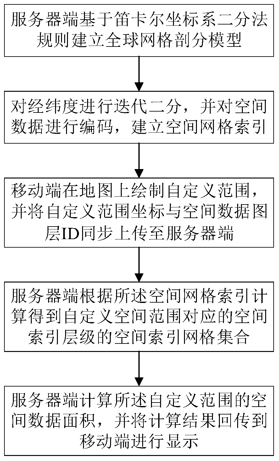
[0050] Such as figure 1 As shown in , a statistical method for the area of ​​spatial data in a custom range based on the grid spatial index, the specific steps are as follows:

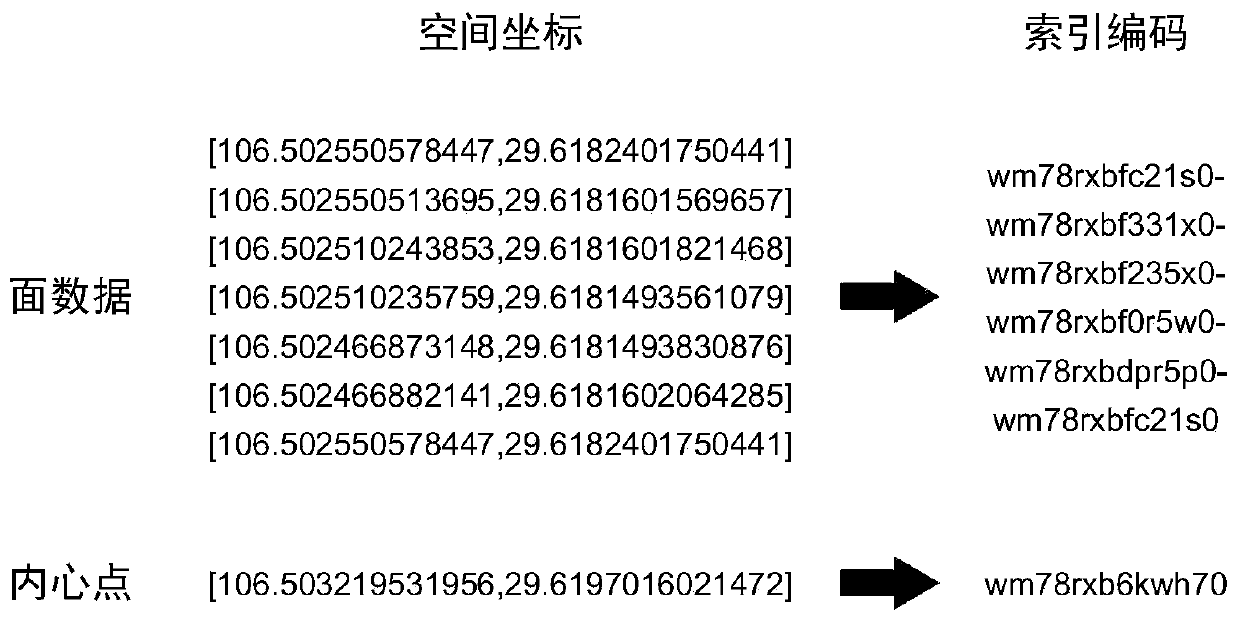
[0051] Step 1: The server side establishes a global grid subdivision model based on the dichotomy rule of the Cartesian coordinate system, encodes the spatial data after iterative bisection, and establishes a spatial grid index.

[0052] The establishment process of the global grid subdivision model is as follows:

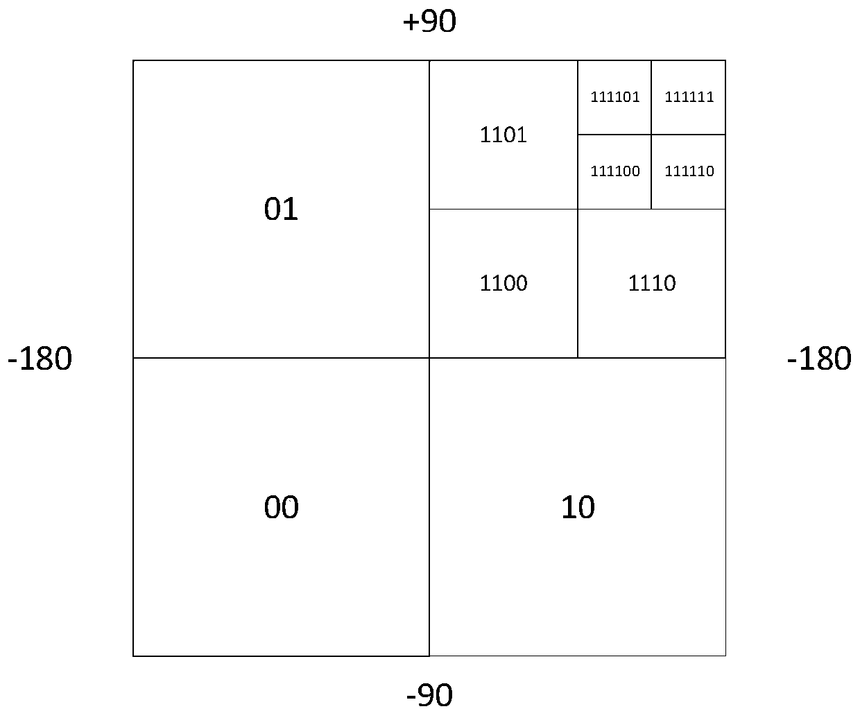
[0053] Step 1.1: Based on the Cartesian coordinate system dichotomy rule, establish a global grid subdivision model and iteratively divide the earth into longitude and latitude dichotomies, and perform binary coding on each grid;

[0054] The Cartesian coordinate system dichotomy rule is: if this plane represent...


PUM


Abstract

The invention discloses a user-defined range spatial data area statistical method based on a grid spatial index, which comprises the following steps: a server establishes a global grid subdivision model based on a Cartesian coordinate system dichotomy rule, performs iterative dichotomy on spatial data, encodes the spatial data, and establishes a spatial grid index; the mobile terminal draws a user-defined range on a map, coordinates of the user-defined range and the spatial data layer ID are synchronously uploaded to the server terminal, and the server terminal calculates according to the spatial grid indexes to obtain a spatial index grid set of spatial index hierarchies corresponding to the user-defined spatial range; and the server calculates the spatial data area of the user-defined range according to the spatial index grid set and the spatial data layer ID, and returns a calculation result to the mobile terminal for display. The method has the advantages that the calculation efficiency is improved, the calculation precision is high, and few resources are occupied.

Description

technical field [0001] The invention relates to the technical field of spatial data processing, in particular to a statistical method for the area of ​​spatial data in a self-defined range based on a grid spatial index. Background technique [0002] With the development of mobile GIS technology, the need to count the spatial elements of the target layer after drawing the range on the mobile terminal is becoming more and more common. The current method is to convert the drawn custom range into a Json file and upload it to the server, then perform spatial intersection calculation with the target layer to obtain the statistical area, and finally return the calculation result to the mobile terminal for display. [0003] However, although the calculation results of this method are relatively accurate, the overall statistical speed is relatively slow due to the restriction of the calculation speed of the intersection operation between polygons and polygon spaces. To solve this pr...

Claims


Application Information

Patent Timeline
Patent Type & Authority Applications(China)
IPC IPC(8): G06T7/62G06F16/29
CPCG06F16/29G06T7/62
Inventor 余静杨航曾安明贾敦新梁星张泽烈袁超李林赵翔宇程宇翔钱文进王小勇余洋邵帅梁均军王岚秦瑛歆彭婧
Owner CHONGQING GEOMATICS & REMOTE SENSING CENT
Why Eureka
Try Eureka