A projection area analysis method for rendezvous and docking lidar cooperative targets

A cooperative target and lidar technology, applied in the direction of optical devices, electromagnetic wave re-radiation, instruments, etc., can solve the problem that there is no analysis method for the projected area of ​​​​the rendezvous and docking lidar

Active Publication Date: 2022-08-02
INST OF OPTICS & ELECTRONICS - CHINESE ACAD OF SCI
View PDF9 Cites 0 Cited by
  • Summary
  • Abstract
  • Description
  • Claims
  • Application Information

AI Technical Summary

Problems solved by technology

Judging from the currently published literature and patents, there is no related projected area analysis method for rendezvous and docking lidar cooperation targets

Method used


Image

  • A projection area analysis method for rendezvous and docking lidar cooperative targets
  • A projection area analysis method for rendezvous and docking lidar cooperative targets
  • A projection area analysis method for rendezvous and docking lidar cooperative targets

Examples


Embodiment Construction

[0021] The present invention will be further described in detail below with reference to the accompanying drawings and specific embodiments.

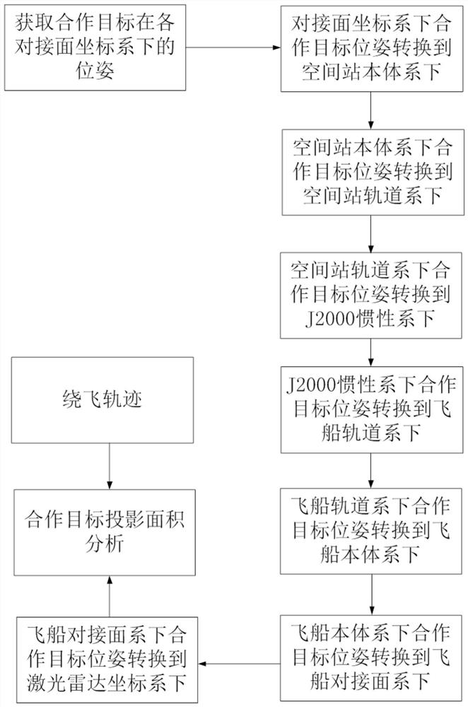
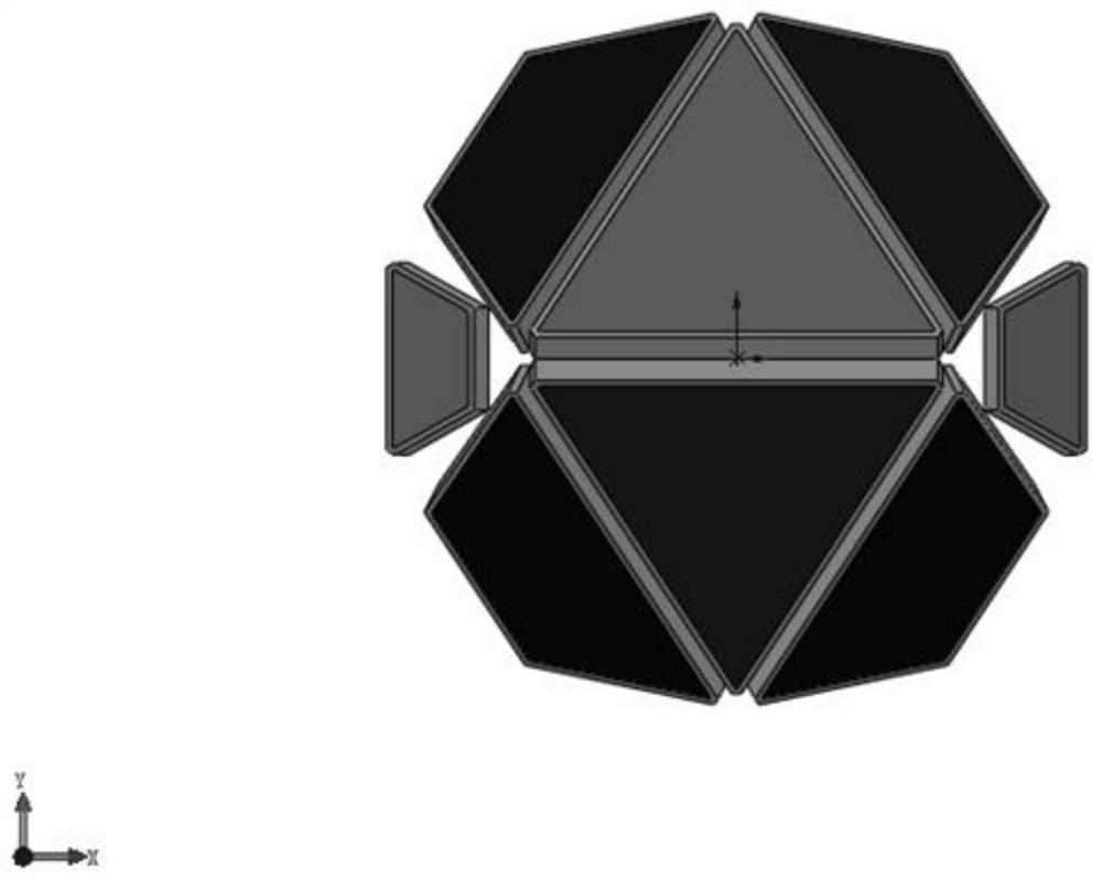
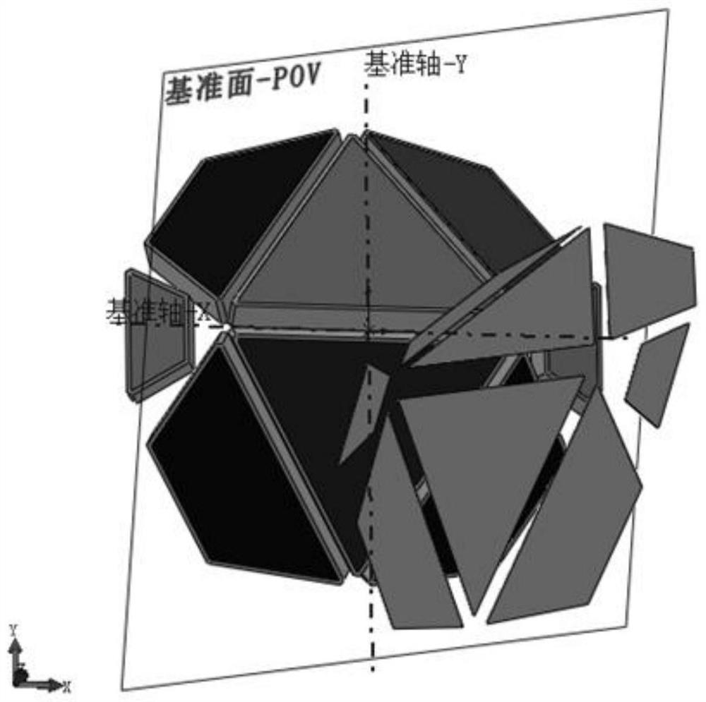
[0022] A projection area analysis method suitable for rendezvous and docking lidar cooperative targets during the orbiting process of the spacecraft. First, according to the installation relationship of the cooperative targets, the poses of the cooperative targets in the coordinate system of each pair of interfaces of the space station are obtained. where M hd is the rotation matrix from the cooperative target coordinate system h to the docking plane coordinate system d, and is the position vector of the cooperative target in the docking plane coordinate system.

[0023] Then the relationship between the coordinate system d of the docking surface of the cooperation target and the system b of the space station is known The pose of the cooperative target can be converted into the space station system, as and,

[0024]

[0025] ...


PUM


Abstract

The present invention relates to a method for analyzing the projected area of ​​a cooperating target of a rendezvous and docking laser radar. Firstly, according to the installation relationship of the cooperating target in the space station, the pose of the cooperating target in each docking plane coordinate system is obtained. The relationship of the system is obtained, and the pose of the cooperation target under the system of the space station is obtained. Then, according to the orbit data of the space station, the relationship between the space station's own system and the space station orbit system can be obtained, and the pose of the cooperative target can be expressed under the space station orbit system. In the same way, according to the installation relationship of the lidar on the spacecraft, the relationship between the lidar coordinate system and the spacecraft itself can be obtained. Finally, by linking the orbit system of the space station and the spacecraft itself through the J2000 inertial system, the relative position and attitude relationship between the cooperative target and the lidar can be obtained according to the orbital flight trajectory, and finally the projection of the cooperative target of the rendezvous and docking lidar can be analyzed during the orbiting flight. area. The present invention can ensure smooth docking in the fly-around process.

Description

technical field [0001] The invention relates to a method for analyzing the projected area of ​​a cooperative target of a relative measurement sensor laser radar used in space rendezvous and docking. Background technique [0002] Spacecraft rendezvous and docking is a key technology of space technology. The relative measurement sensor lidar is used to measure the distance, speed, angle and angular velocity of the two spacecraft from 30 kilometers in space to the final docking. [0003] During the process of the spacecraft flying around the space station, the projected area of ​​each group of cooperative targets in the direction of the lidar line of sight changes at any time. Since lidar obtains echoes through the reflection of cooperative targets, the projected area directly determines the amount of echo energy. . This means that in the process of orbiting the spacecraft, it is necessary to calculate and analyze the projected area of ​​each group of targets to obtain the be...

Claims


Application Information

Patent Timeline
Patent Type & Authority Patents(China)
IPC IPC(8): G01B11/28G01S17/88
CPCG01B11/28G01S17/88
Inventor 颜坤刘恩海周向东岳永坚冯志辉袁林晨李伟雄
Owner INST OF OPTICS & ELECTRONICS - CHINESE ACAD OF SCI
Why Eureka
Try Eureka