System and method for processing map images

a map and image technology, applied in the field of image processing, can solve the problems of limiting the ability to quickly make new map data available, affecting the speed of map data processing, and putting a lot of work on the client,

Inactive Publication Date: 2012-03-06
TECH LICENSING CORP (US)
View PDF25 Cites 17 Cited by
  • Summary
  • Abstract
  • Description
  • Claims
  • Application Information

AI Technical Summary

Problems solved by technology

This limits the ability to rapidly make new map data available or to view map data from different perspectives, for example, viewing changing map data over time.
Some systems have many tiles assembled at the client in which tiles are already predefined such that a client will fetch a tile, thus placing much work on the client with excessive map data processing occurring at the client.

Method used


Image

  • System and method for processing map images
  • System and method for processing map images
  • System and method for processing map images

Examples


Embodiment Construction

[0019]Different embodiments will now be described more fully hereinafter with reference to the accompanying drawings, in which preferred embodiments are shown. Many different forms can be set forth and described embodiments should not be construed as limited to the embodiments set forth herein. Rather, these embodiments are provided so that this disclosure will be thorough and complete, and will fully convey the scope to those skilled in the art.

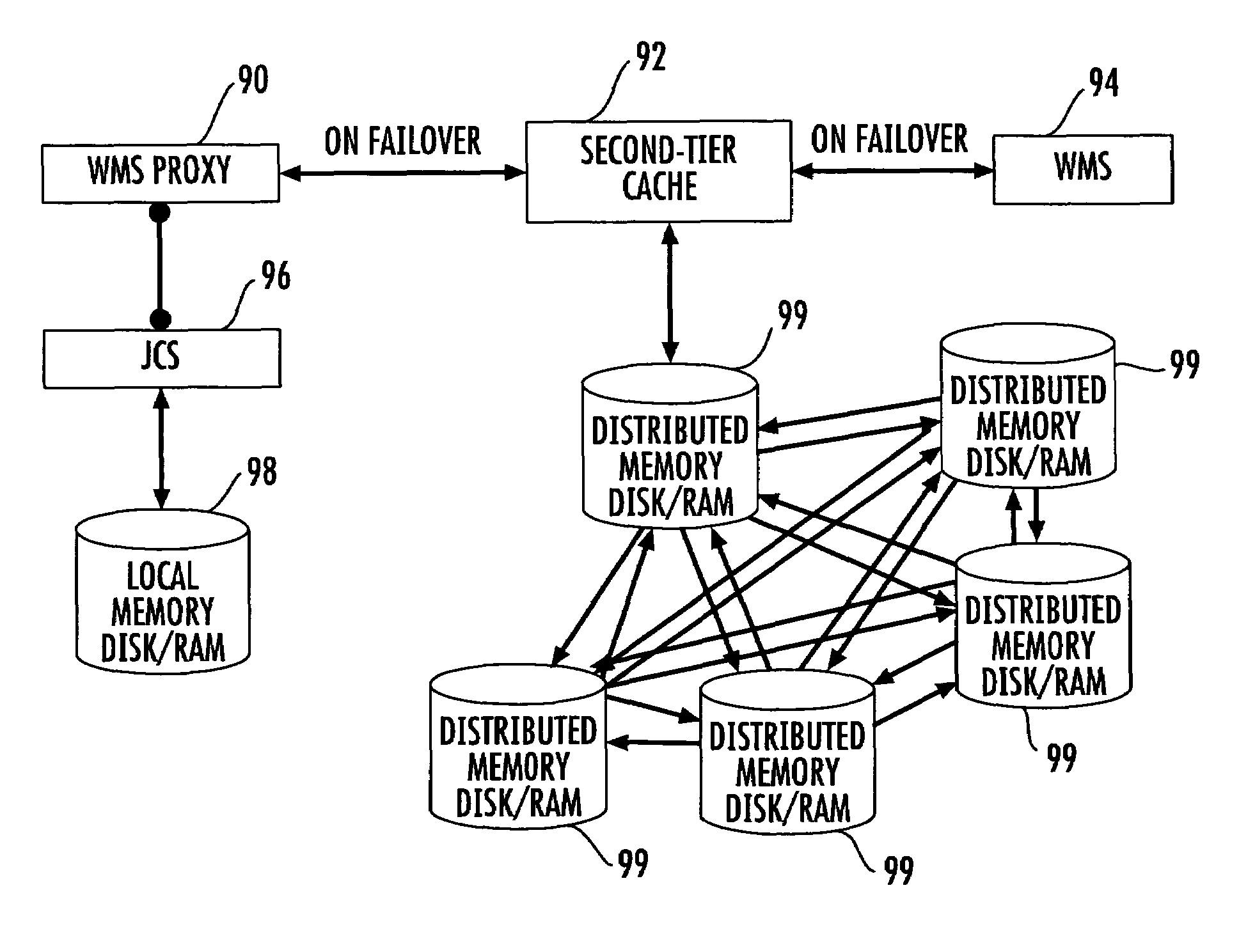
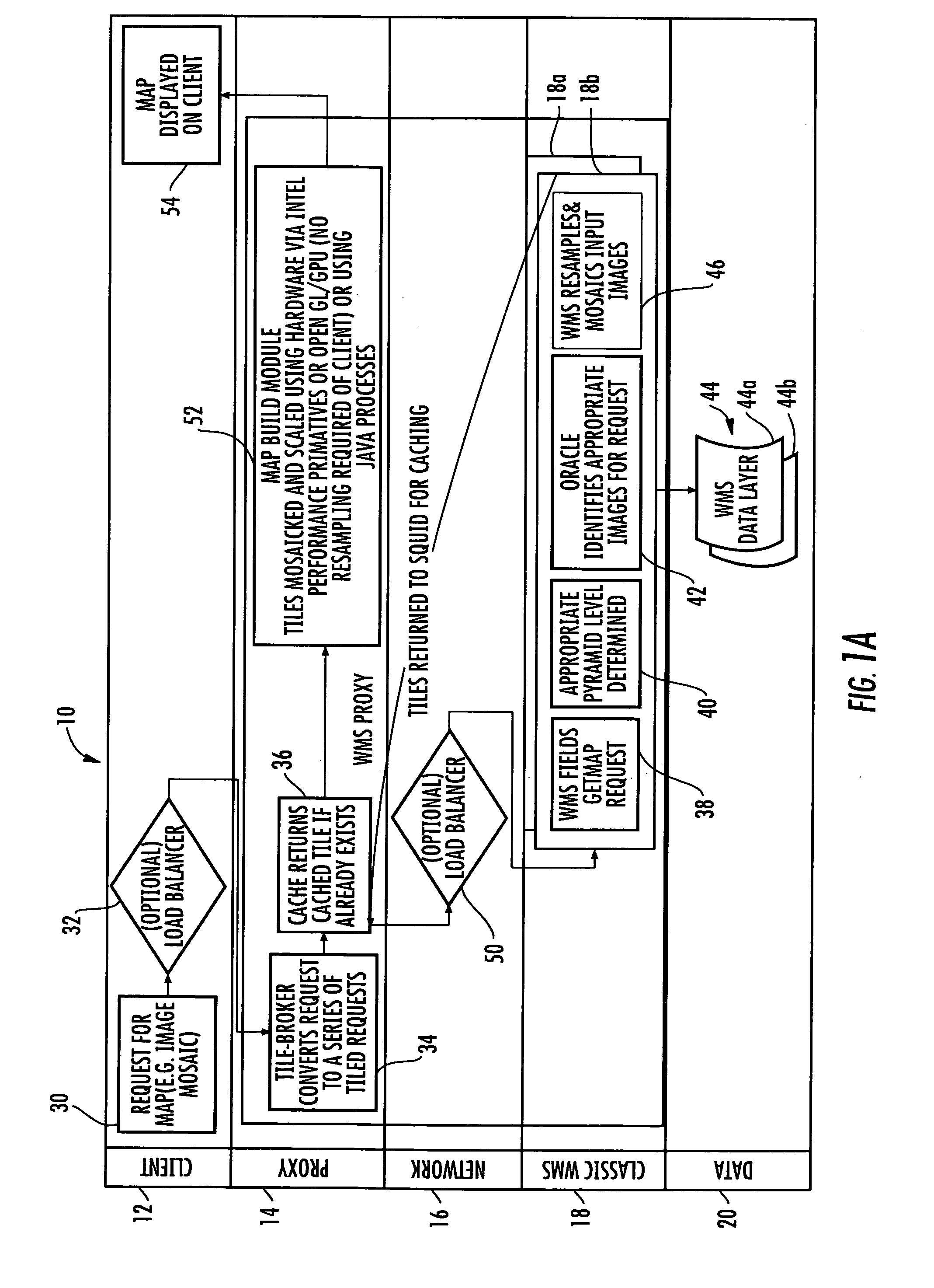
[0020]The system and method of processing map images formed from a plurality of tiles, in accordance with non-limiting examples of the present invention, overcomes disadvantages in prior art map imaging processes that use classical large image databases, such as Google Earth and Microsoft Virtual Earth, which require data to be preprocessed. In these systems, only one set of data is “served-up” with only one view into the data, limiting the ability of the system to make new data rapidly available or view data from different perspectives, for...


PUM


Abstract

A system of processing map images includes a Web Mapping Service (WMS) for storing map images. A WMS proxy is operative with the WMS and receives from a client a request for a map image for display at the client. A WMS proxy includes a tile broker module that converts the request for the map image into a series of requests for obtaining map tiles. A cache system that stores the map tiles. The tile broker module is operative for returning cached map tiles if they already exist within the cache and retrieving map tiles from the WMS if map tiles are not returned from the cache. A tile building module is operative for building a map image at the WMS proxy from the map tiles in a requested format and resolution and displaying the map image at the client without resampling at the client.

Description

GOVERNMENT LICENSE RIGHTS[0001]This invention was made with government support under Government Contract No. HM1571-04-A-0006 awarded by the National Geospatial-Intelligence Agency (NGA). The U.S. Government may have certain rights in the invention.FIELD OF THE INVENTION[0002]The present invention relates to the field of image processing, and more particularly, to systems and related methods of processing map images formed from map tiles used in mapping systems.BACKGROUND OF THE INVENTION[0003]Classical large image databases, such as those used by Google Earth and Microsoft Virtual Earth, require map data to be preprocessed. As a result, only one set of map data is served up with only one view into the map data. This limits the ability to rapidly make new map data available or to view map data from different perspectives, for example, viewing changing map data over time.[0004]Current systems use a Web Mapping Service (WMS) with a WMS data layer that could include some cache system. ...

Claims


Application Information

Patent Timeline
Patent Type & Authority Patents(United States)
IPC IPC(8): G09G5/00
CPCG06F17/30902G06F16/9574
Inventor HAM, TODD E.FELDBUSH, KURT L.ASBELL, JASON M.MINICLIER, SEAN O.
Owner TECH LICENSING CORP (US)
Why Eureka
Try Eureka