
Method for utilizing forwarding range finding value and pseudo range value to determine GEO navigation satellite clock error
A navigation satellite and pseudorange technology is applied in the field of navigation satellite measurement and orbit determination. The effect of reducing the number of
Patent Information
- Authority / Receiving Office
- CN · China
- Patent Type
- Patents(China)
- Current Assignee / Owner
- Publication Date
- 2012-11-21
Smart Images

Figure 1 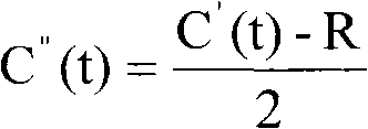
Figure 2 
Figure 3
Abstract
Description
technical field
[0001] The invention relates to a method for determining the clock error of an atomic clock on a GEO navigation satellite by using a forwarding distance measurement value and a pseudorange value, relates to the field of navigation satellite measurement and orbit determination, and belongs to the subject of astrometry and celestial mechanics. Background technique
[0002] The key problem of the positioning accuracy of the navigation satellite system is to determine the clock offset and its variation of the satellite-borne atomic clock.
[0003] At present, there are mainly three methods for determining the clock error of navigation satellites: 1) one-way ranging method, which uses the measured pseudorange value and the distance value between the satellite and the synchronous station obtained by orbit positioning, and the difference between the two can be obtained Satellite clock difference. 2) The two-way ranging method uses several radar measuring stations a...
Examples
Embodiment approach
[0041] Utilize the forwarding ranging equipment and GEO navigation satellites to generate forwarding ranging values, utilize the pseudo-range ranging equipment and GEO navigation satellites to generate pseudo-range values, and the data processing center and the software that runs the present invention to determine the clock difference of GEO navigation satellites are to the collected forwarding The ranging value and the pseudo-range value are processed to obtain the clock error of the navigation satellite. The specific steps are as follows:
[0042] Step 1: The performance of the ground station clock system is at least an order of magnitude higher than that of the spaceborne atomic clock, and it is used as a standard frequency source; the ground clock system provides a unified time and frequency signal for the forwarding ranging equipment and the pseudo-range ranging equipment. At this time, the forwarding ranging The forward ranging value collected by the device is only relate...