Front view terminal guidance navigation positioning method of aircraft

A technology for navigation and positioning and aircraft, which is applied in the field of interdisciplinary science to ensure robustness and adaptability, broaden the types of locatable objects, and enhance the wide range of applications.

Inactive Publication Date: 2010-01-20
HUAZHONG UNIV OF SCI & TECH
View PDF0 Cites 14 Cited by
  • Summary
  • Abstract
  • Description
  • Claims
  • Application Information

AI Technical Summary

Problems solved by technology

In the existing public literature, there is no report on the automatic positioning and recognition technology of targets with optical and geometric unrecognizability, and the automatic positioning and recognition of such targets is a technical problem that has to be solved in the field of navigation and positioning. A new technical solution to solve the automatic target recognition and positioning of this type of target

Method used


Image

  • Front view terminal guidance navigation positioning method of aircraft
  • Front view terminal guidance navigation positioning method of aircraft
  • Front view terminal guidance navigation positioning method of aircraft

Examples


Embodiment Construction

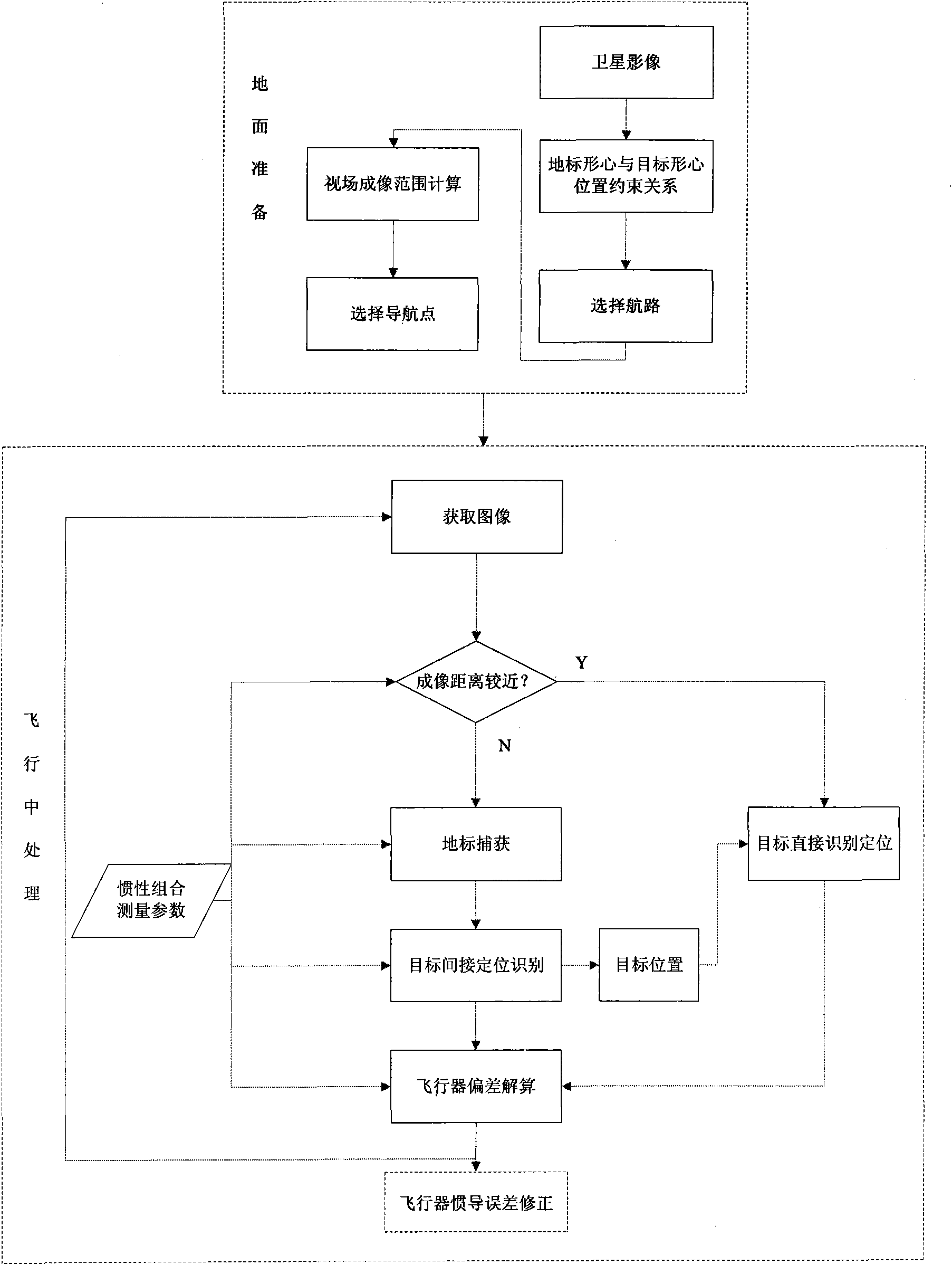
[0044] Refer below figure 1 To illustrate the steps of the indirect navigation positioning method in the present invention:

[0045] 1. Ground preparation stage

[0046] (1.1) Select the landmark step according to the target.

[0047] In the ground preparation process, use satellite orthophoto images to select landmarks with prominent features and easy to identify in the surrounding area of ​​the target centroid position. The landmarks can be planar or three-dimensional, and the position between the target centroid position and the landmark centroid position is obtained. bias vector. The centroid of the target / landmark in the present invention is the centroid of the target / landmark projected on the earth level, and the centroid does not consider the height of the target / landmark.

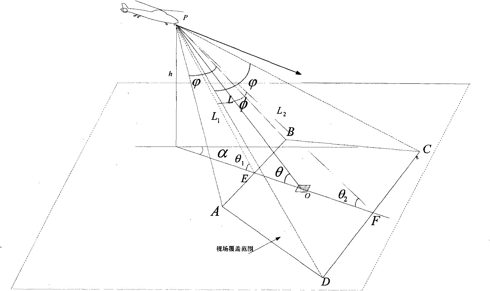
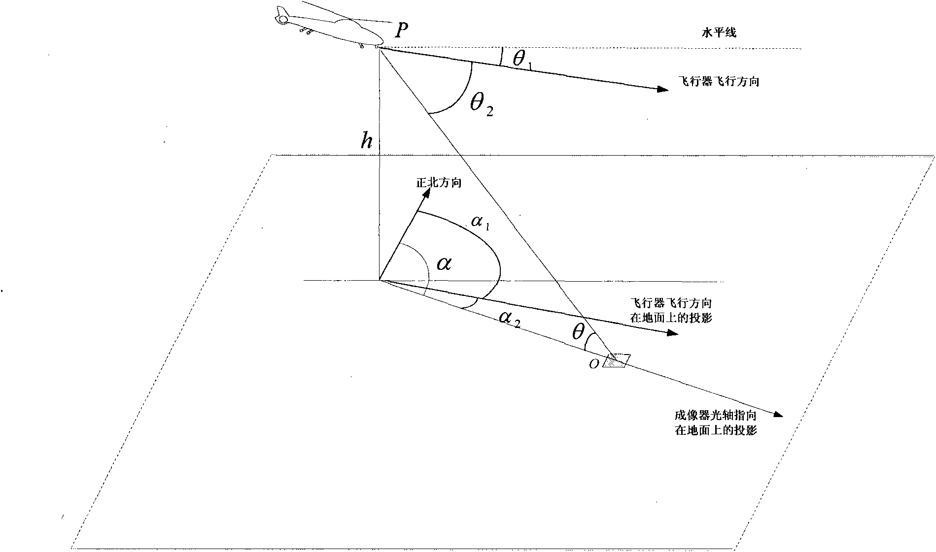
[0048] (1.2) The step of calculating the imaging coverage of the field of view.

[0049] According to the planned flight path, use the flying height h of the flight path and the lateral imaging an...


PUM


Abstract

The invention discloses a front view navigation positioning method of an aircraft, comprising two stages of a remote navigation stage and a distance navigation stage; in the remote navigation stage, the position of the landmark centroid in a real-time figure is firstly identified, the estimated position of target centroid in the real-time figure is calculated by combining the position deviation between the target centroid and the landmark centroid in the geodetic coordinate system and current aircraft imaging attitude parameters furthermore, the relevant position difference value of the aircraft is calculated, and then a target search area is selected by taking the estimated position of the target centroid in the real-time figure; in the distance navigation stage, the target is directly positioned in the target search area, and then the relevant position difference value of the aircraft is calculated according to the direct positioning result. By means of landmark identification of the peripheral areas of the target, the target can be indirectly positioned for navigation, ensuring the robustness and adaptability of aircraft navigation positioning and overcoming the defect that the aircraft can be not directly positioned and navigated in the process of flight because the aircraft deviates from a planned flight path owing to errors.

Description

technical field [0001] The invention relates to the field of interdisciplinary science and technology combining imaging automatic target recognition with navigation guidance and positioning, and specifically relates to an aircraft navigation and positioning method, which uses the imaging system of the photoelectric platform on board the aircraft to obtain external reference information, and captures and positions the navigation and positioning targets, thereby The aircraft navigation system performs error correction to realize accurate navigation and positioning of the aircraft. Background technique [0002] Continuously improving the navigation accuracy of aircraft has always been an important research topic in the field of navigation and positioning technology. The error of the inertial navigation system increases with the accumulation of time, so relying on the inertial navigation system alone cannot meet the requirements of high-precision navigation. The imaging system ...

Claims


Application Information

Patent Timeline
Patent Type & Authority Applications(China)
IPC IPC(8): G01C21/24
Inventor 张天序万美君杨效余王登位汪小平敖国庆李成毛麟孙思远郑璐璐王曼
Owner HUAZHONG UNIV OF SCI & TECH
Why Eureka
Try Eureka