Tile map data organization method

A data organization and tile map technology, applied in the fields of electrical digital data processing, special data processing applications, instruments, etc., can solve the problems of rapid change, redundant information, and easy omission of important map element information.

Active Publication Date: 2011-01-12
WUHAN UNIV
View PDF2 Cites 54 Cited by
  • Summary
  • Abstract
  • Description
  • Claims
  • Application Information

AI Technical Summary

Problems solved by technology

[0014] 2) The second property is no longer applicable, because the data is obtained through synthesis, so the scale between adjacent levels needs to be comprehensively quantified from various aspects such as scale, breadth, and granularity, and cannot be directly determined based on the doubl

Method used


Image

  • Tile map data organization method
  • Tile map data organization method
  • Tile map data organization method

Examples


Embodiment Construction

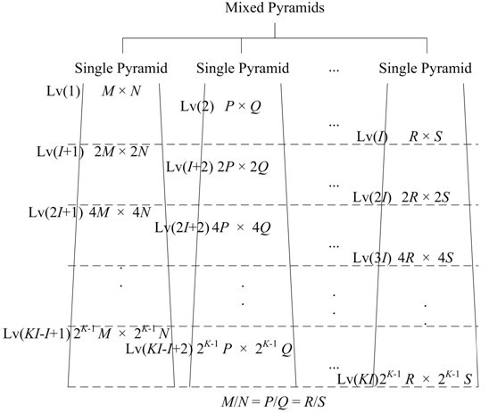
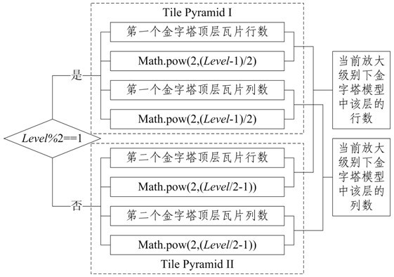
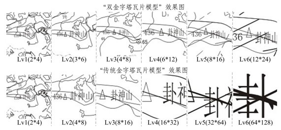
[0071] As we all know, when using the pyramid model to organize map data, the detail level of the map content is determined by the raster data itself, and the division method of each level of the pyramid model is actually an expression of the spatial mapping relationship of the map content when the scale is transformed. Therefore, although the map resolution is not directly determined by the map frame division, the pyramid model can affect the visual expression effect of the scale transformation rate through the setting of the magnification (that is, the control of the rate of change of the map frame size between layers). Take the change from the top layer to the bottom layer as an example, that is, the lower the setting magnification, the slower the expansion of the image frame size, the slower the trend of the view point approaching the LOD level of detail, and the lower the wide-angle change rate of the field of view coverage in a limited window, which is more abundant. Howe...


PUM


Abstract

The invention relates to a tile map data organization method based on a nested pyramid model, belonging to the technical field of visualization of geographical spatial information. Additional similar models are penetrated into the existing pyramid model, wherein the ratio of line number to column number of sliced tiles of each layer is a constant, the magnification setting among layers is the same, the line number and the column number of the tiles of the first stage present an arithmetic progression relationship, so that a nested pyramid model with more compact dimensional transition is constructed. By laying emphasis on the reasonable setting of the dimensions of interpolation maps, the invention adopts a more exquisite and reasonable map dimension dividing manner to increase the dimension distribution density of spatial data, thereby preventing ground objects from being transited in an unsmooth way at the primary stage of dimension pull-down caused by the use of 2X magnification incase of organizing spatial data of small spanning dimensions, and preserving a spanning space for the detailed transition at the later stage. The invention is an improvement on the existing tile map data organization method, and is especially applicable to the organization of spatial data of small spanning dimensions.

Description

technical field [0001] The invention belongs to the technical field of geospatial information visualization, in particular to an improved tile map data organization method. Background technique [0002] At present, it is quite popular to use the raster data organization method to construct electronic maps, especially the tile map data organization form based on the idea of ​​pre-generation is widely used in various network electronic maps, such as GoogleMap abroad, 51ditu, Mapbar in China , Mapabc, E City...the core idea is to sacrifice a lot of preprocessing time in exchange for the greatest gain in the user's visual space. It can be seen that the final visualization effect mainly depends on the preprocessing results of multi-scale spatial data at various levels, and its core is still the multi-scale transformation and expression of data. [0003] The multi-scale expression of spatial data has always been a hot topic in 3S discussion. Regarding the concept of scale, Motte...

Claims


Application Information

Patent Timeline
IPC IPC(8): G06F17/30
Inventor 任福虞昌彬杜清运
Owner WUHAN UNIV
Why Eureka
Try Eureka