A Satellite Mission Planning Method Based on Hyperheuristic Algorithm

A heuristic algorithm and task planning technology, applied in computing, special data processing applications, instruments, etc., can solve problems such as blindness of search and inability to obtain high-quality solutions

Active Publication Date: 2018-02-06
HEFEI UNIV OF TECH
View PDF2 Cites 0 Cited by
  • Summary
  • Abstract
  • Description
  • Claims
  • Application Information

AI Technical Summary

Problems solved by technology

[0005] (1) Most of the planning methods based on sub-heuristic algorithms do not make full use of the heuristic knowledge related to the priority of the goal contained in the planning problem, so the search is blind;
[0006] (2) The planning method based on a single heuristic rule, although it can provide an indicative direction for the iterative search of the algorithm during planning, so as to quickly obtain an acceptable solution, but based on a single heuristic rule Constructed methods often fail to obtain high-quality solutions

Method used


Image

  • A Satellite Mission Planning Method Based on Hyperheuristic Algorithm
  • A Satellite Mission Planning Method Based on Hyperheuristic Algorithm
  • A Satellite Mission Planning Method Based on Hyperheuristic Algorithm

Examples


Embodiment Construction

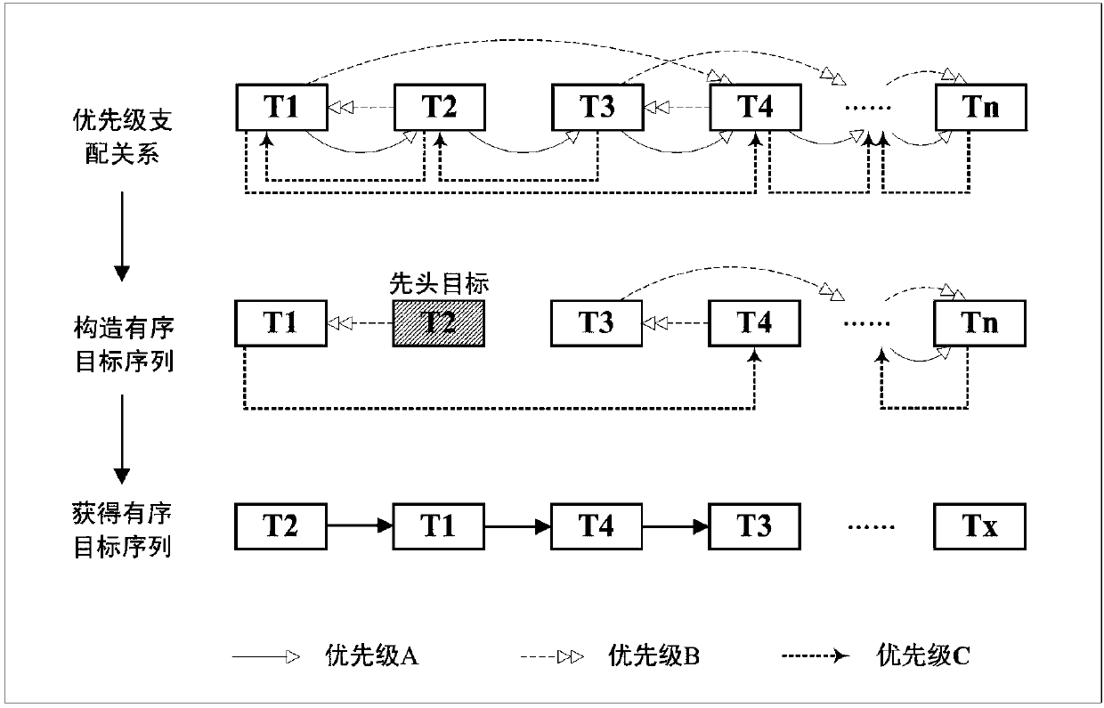
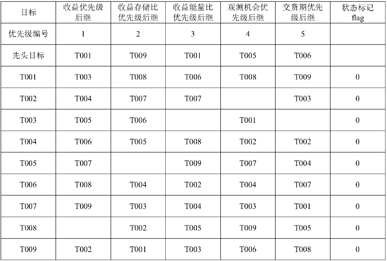
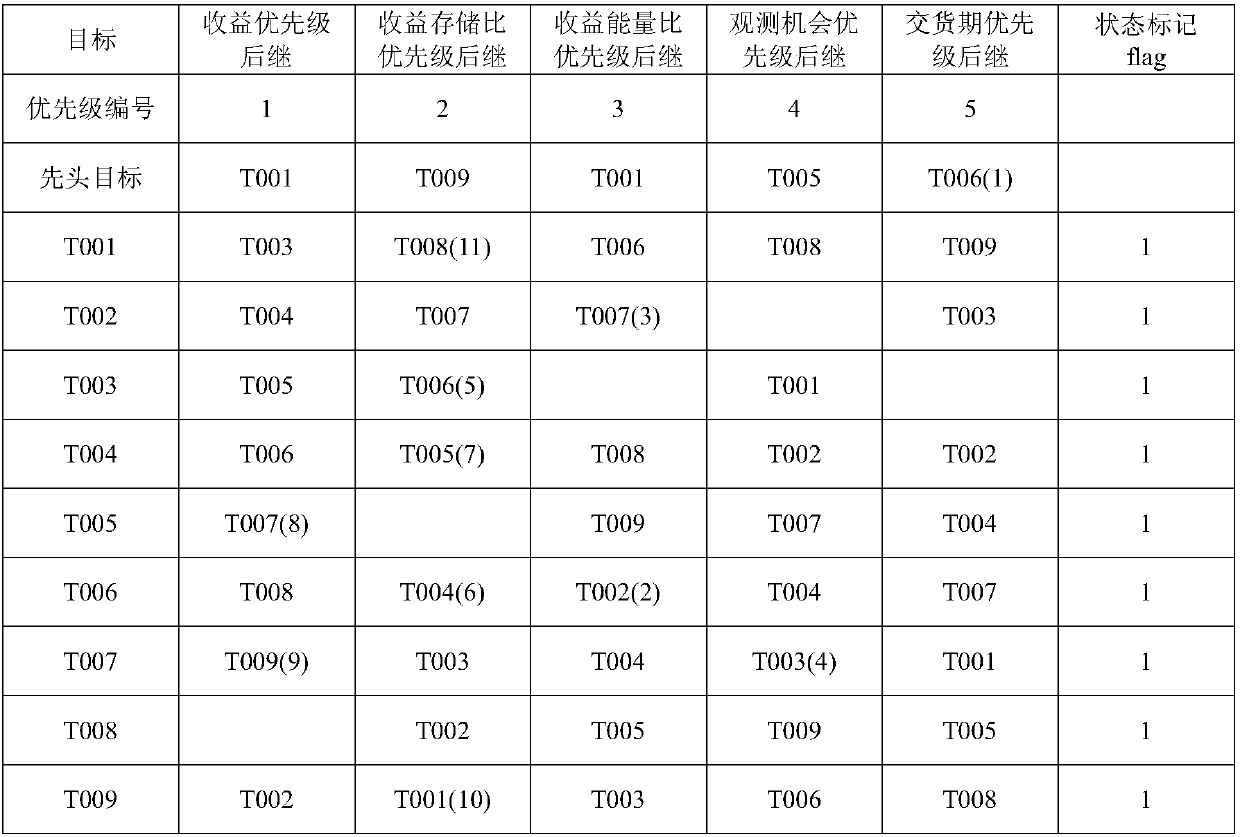
[0091] In this embodiment, a satellite mission planning method based on a hyper-heuristic algorithm is applied to the T goals N s imaging satellites and N P ground stations constituted in the mission planning scenario; t i Represents the i-th target, 1≤i≤N T ;s j represents the jth imaging satellite, let the jth imaging satellite s j The maximum storage is M max ; the jth imaging satellite s j With an imaging sensor, with simultaneous imaging and transmission, 1≤j≤N s ;p l represents the lth ground station, the lth ground station p l Can simultaneously receive imaging data transmitted by multiple imaging satellites, 1≤l≤N p ;

[0092] Each target corresponds to an observed return value, and record the i-th target t i The corresponding observed return is f(t i ); each target corresponds to a delivery date, record the i-th target t i The corresponding delivery time is h(t i ); each target corresponds to a storage consumption, note the i-th target t i The cor...


PUM


Abstract

The invention discloses a hyper-heuristic algorithm-based satellite task planning method. The method includes the following steps that: 1, the priority dominance relation data of a target are obtained; and 2, a tabu search algorithm or a simulated annealing sub-heuristic algorithm is adopted to search priority combinations so as to obtain a planning result. According to the method of the invention, the sub-heuristic algorithm is adopted to search the combined application of the heuristic rule information of multi-angle priorities, and therefore, a super-heuristic algorithm-based and efficiently robust satellite imaging and transmission joint planning method can be provided.

Description

technical field [0001] The invention belongs to the technical field of satellite mission planning, in particular to a multi-satellite imaging and transmission joint mission planning method. Background technique [0002] A satellite is a machine made and launched by humans, which flies in a certain orbit and revolves around the earth. The imaging satellite can image the area of ​​the earth it passes and covers through the onboard imaging sensor, and transmits the image back to the ground station for use by ground users. At present, imaging satellites play an important role in many application fields such as national defense and people's livelihood, such as environmental monitoring, land survey, target search, emergency rescue and so on. Satellite mission planning is an important link in the daily management and control of satellites. It is used to deal with the contention of satellite resources by users, so that the scarce satellite resources can meet the needs of users as m...

Claims


Application Information

Patent Timeline
Patent Type & Authority Patents(China)
IPC IPC(8): G06F17/50
CPCG06Q10/04G06Q10/063
Inventor 胡笑旋朱外明靳鹏夏维罗贺马华伟张烨
Owner HEFEI UNIV OF TECH
Why Eureka
Try Eureka