A handheld device for urban geographic data collection

A technology of geographic data and handheld devices, applied in the direction of measuring instruments, instruments, height/level measurement, etc., can solve the problems of unfavorable practical use, complex and difficult equipment information input steps, and long time-consuming, etc., to achieve reasonable structural design and improve convenience performance and accuracy, saving time

Active Publication Date: 2021-05-28
GUANGZHOU INST OF GEOGRAPHY GUANGDONG ACAD OF SCI
View PDF9 Cites 0 Cited by
  • Summary
  • Abstract
  • Description
  • Claims
  • Application Information

AI Technical Summary

Problems solved by technology

The purpose of collecting urban geographic data is to collect the above-mentioned coordinates and attribute information into the system, and provide data basis and reference for map drawing, geographic analysis, spatial location decision-making, urban research, etc. The existing equipment information input steps are complex and difficult, not It is beneficial to practical use. For this reason, we propose a handheld device for urban geographic data collection. Existing geographic data collection devices generally use multiple extension devices or various types of sub-monitoring devices to achieve three-dimensional data collection of geographic data. For example, the current There is a related solution recorded in the patent technology CN206095227U, but in the above solution, the data monitoring between each extension device or sub-device is independent, and each monitoring sub-device needs to be calibrated one by one before entering the measurement area, so that the entire measurement takes longer

Method used


Image

  • A handheld device for urban geographic data collection
  • A handheld device for urban geographic data collection
  • A handheld device for urban geographic data collection

Examples


Embodiment 1

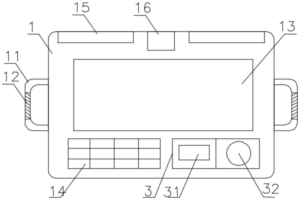
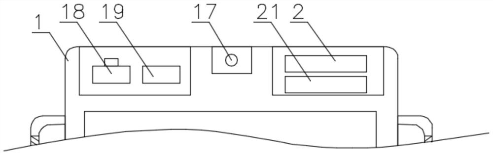
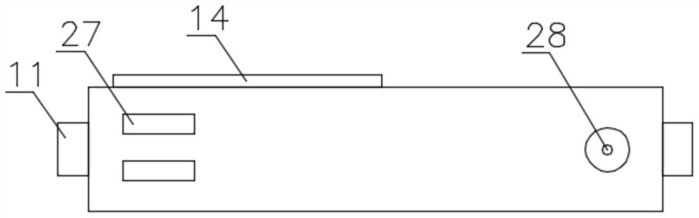
[0027] see Figure 1-8 , the present invention provides a technical solution: a handheld device for urban geographic data collection, including a handheld master device 1, a building measurement slave device 4, a road measurement slave device 6, and an altitude slave device 7, the handheld master device The left and right ends of 1 are fixedly connected with handles 11, and the handles 11 are provided with anti-skid lines 12, which can improve the stability during use and avoid slipping. The control display screen 13 is convenient for the digitization of geographical information, and is also convenient for the use of various forms and data reading. The lower part of the front surface of the handheld master device 1 is fixedly connected with an input keyboard 14, and the lower part of the front surface of the handheld master device 1 is also A positioning component 3 is fixedly connected, and the input keyboard 14 includes number keys and function keys, which can complete accurat...

Embodiment 2

[0029] see Figure 1-7 and Figure 9 , the present invention provides a technical solution: the housing of the road measurement sub-machine 6 is triangular conical, the lower end of the road measurement sub-machine 6 is movably connected to a bottom plate 64 through a buckle 65, and the upper end of the bottom plate 64 is fixed A third infrared transceiver device 66 is connected, an infrared signal demodulator 68 and a third storage battery 69 are fixedly connected to the middle of the cavity of the third infrared transceiver device 66, and a signal amplifier 67 is fixedly connected to the upper end of the third infrared transceiver device 66 The upper end of the road measurement sub-machine device 6 is fixedly connected with a reflective plate 63, the outer side of the road measurement sub-machine device 6 is fixedly connected with a reflective strip 61, and the outer wall of the road measurement sub-machine device 6 is provided with a signal window 62, The vertical height o...

Embodiment 3

[0031] see Figure 1-7 and Figure 10 The present invention provides a technical solution: the upper end of the altitude sub-machine device 7 is fixedly connected with a second handle 73 through a connecting rod 72, and the left and right ends of the altitude sub-machine device 7 are fixedly connected with a third protective shell 71, so The left part of the inner cavity of the altitude sub-machine device 7 is fixedly connected with a mechanical altimeter 75, the right part of the inner cavity of the altitude sub-machine device 7 is fixedly connected with a GPRS altimeter 77, and the middle part of the altitude sub-machine device 7 passes through the second lock 74 has an inspection door, and the left end of the mechanical altimeter 75 is fixedly connected with a dial 76. Two altimeters with different principles can independently measure and compare the altitude data to obtain accurate data. The first protective shell 15, Both the second protective shell 41 and the third prot...


PUM


Abstract

The invention discloses a handheld device for collecting urban geographic data, which includes a handheld master device, a building measurement slave device, a road measurement slave device and an altitude slave device. A liquid crystal touch device is fixedly connected in the middle of the front end of the handheld master device. A display screen, a PLC circuit board is fixedly connected to the middle of the inner cavity of the handheld main machine device, a microprocessor is fixedly connected to the PLC circuit board, the building measurement sub-machine device is an L-shaped shell, and the building measurement The lower end of the sub-machine device is fixedly connected with a card slot piece, and a clip joint table is movably clipped in the clip slot piece, the lower end of the clip joint table is rotatably connected with a support rod through a first rotating shaft, and the end of the support rod passes through a second rotating shaft. A foot plate is rotatably connected, the casing of the road measurement sub-machine device is a triangular cone, and the right part of the inner cavity of the altitude sub-machine device is fixedly connected with a GPRS altimeter and a mechanical altimeter. The device is rich in functions, practical, and has certain promotion value.

Description

technical field [0001] The invention relates to the technical field of geographic information equipment, in particular to a handheld device for collecting urban geographic data. Background technique [0002] There are many types of geographic data in cities, which can be generally divided into three categories: surface, line, and point data. For example, the bottom of a building, the land area of ​​a school, and the land area of ​​a factory are all area data, and roads are generally line data. Smaller features or various locations are point data. The difference between geographic data and ordinary data is that each data has latitude and longitude coordinate values. Therefore, this device should be able to input geographic coordinates (east longitude, north latitude, altitude) or Relative coordinates (X (horizontal coordinate), Y (vertical coordinate), Z (height)), three-dimensional geographic data requires all three coordinates, and plane data only needs two coordinate value...

Claims


Application Information

Patent Timeline
Patent Type & Authority Patents(China)
IPC IPC(8): G01D21/02G01C15/00G01C5/00
CPCG01C5/00G01C15/002G01D21/02
Inventor 王洋张虹鸥金利霞王长建苏泳娴张玉玲杜志威吴康敏林浩曦
Owner GUANGZHOU INST OF GEOGRAPHY GUANGDONG ACAD OF SCI
Why Eureka
Try Eureka