Geochemical soil survey data fine processing method

A geochemical and measurement data technology, applied in special data processing applications, structured data retrieval, geographic information databases, etc., can solve problems such as being unable to meet the needs of large-scale exploration work, and inconsistent with the actual geological conditions of the work area.

Pending Publication Date: 2022-01-14
BEIJING RES INST OF URANIUM GEOLOGY
View PDF0 Cites 0 Cited by
  • Summary
  • Abstract
  • Description
  • Claims
  • Application Information

AI Technical Summary

Problems solved by technology

Since the soil geochemical measurement results are affected by many factors, such as the thickness of the soil cover layer, topography, and stratum lithology, etc., the use of a lower limit of abnormality in the entire work area in the past cannot meet the needs of large-scale exploration work, and does not meet the requirements of the work. The actual geological conditions of the area

Method used


Image

  • Geochemical soil survey data fine processing method

Examples


Embodiment Construction

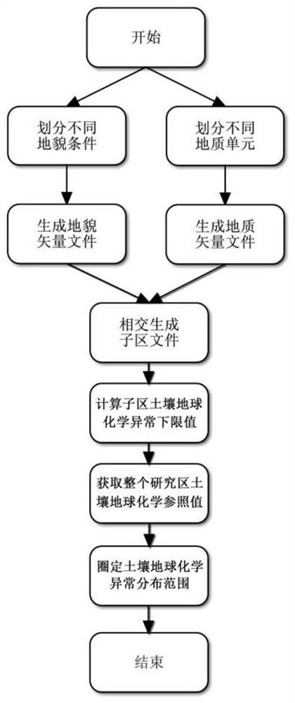
[0025] The present invention will be further described below by means of the accompanying drawings and specific embodiments.

[0026] Such as figure 1 As shown, the specific steps are as follows.

[0027] (1) According to the high spatial resolution aerial remote sensing images of the work area, the work area is divided into different landform landscape areas, and the vector file of landform spatial distribution is generated;

[0028] The working area takes the Xiangshan volcanic rock-type uranium mining area as an example. The different landscape areas include villages, farmland, gardens, rock outcropping areas, wetlands, and alluvial lands;

[0029] The ArcGIS software Shapefile was used to generate the geomorphic spatial distribution vector file.

[0030] (2) Divide the work area into different geological units according to the geological map of the work area, and generate vector files of the geological units;

[0031] The Xiangshan volcanic rock-type uranium mining area...


PUM


Abstract

The invention belongs to the technical field of mineral resource exploration, and particularly relates to a geochemical soil survey data fine processing method. The method comprises the following steps: dividing a working area, and generating a landform space distribution vector file and a geological unit vector file; carrying out intersection processing to obtain a plurality of sub-areas containing both landform and geological information; determining soil geochemical anomaly lower limit values of the sub-areas, and obtaining soil geochemical data reference values of all actual measurement points of the whole working area; and subtracting the soil geochemical data reference value of a certain actual measurement point from actual measurement soil geochemical data of the actual measurement point in the working area, wherein an area defined by all the actual measurement points with difference values larger than zero is a geochemical anomaly distribution area. According to the invention, anomaly information can be effectively extracted from a soil geochemical low background field, so that a soil geochemical anomaly distribution area of a working area can be accurately delineated.

Description

technical field [0001] The invention belongs to the technical field of mineral resource exploration, and in particular relates to a method for finely processing soil geochemical measurement data. Background technique [0002] As a classic geochemical prospecting method, soil geochemical survey has been widely used in mineral resource exploration in my country. Since the soil geochemical measurement results are affected by many factors, such as the thickness of the soil cover layer, topography, and stratum lithology, etc., the use of a lower limit of abnormality in the entire work area in the past cannot meet the needs of large-scale exploration work, and does not meet the requirements of the work. The actual geological conditions of the area. In actual work, the geological conditions in the work area are often complex, and often distribute a variety of different lithologies or formations, which have different geochemical background values. If the same value is used as the ...

Claims


Application Information

Patent Timeline
Patent Type & Authority Applications(China)
IPC IPC(8): G06F16/29G06F16/56
CPCG06F16/29G06F16/56
Inventor 吴国东
Owner BEIJING RES INST OF URANIUM GEOLOGY
Why Eureka
Try Eureka