Routing method and system

a routing method and system technology, applied in the field of routing methods and systems, can solve problems such as typical requirements for a complicated and inaccurate process

Inactive Publication Date: 2010-07-20
LINKEDIN
View PDF8 Cites 89 Cited by
  • Summary
  • Abstract
  • Description
  • Claims
  • Application Information

AI Technical Summary

Benefits of technology

[0047]The present invention advantageously provides a simple method and associated system capable of generating a custom map for a user.

Problems solved by technology

Generating a custom map for a user typically requires a process that may be complicated and inaccurate.

Method used


Image

  • Routing method and system
  • Routing method and system
  • Routing method and system

Examples


Embodiment Construction

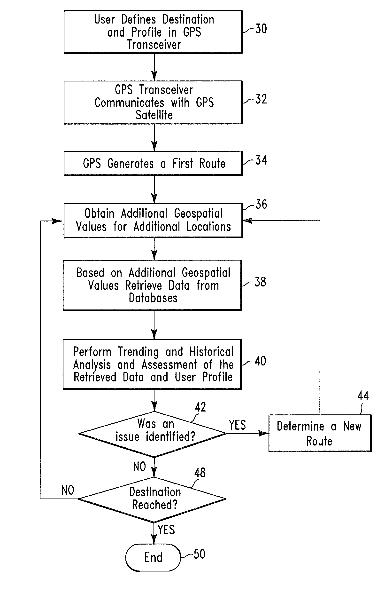
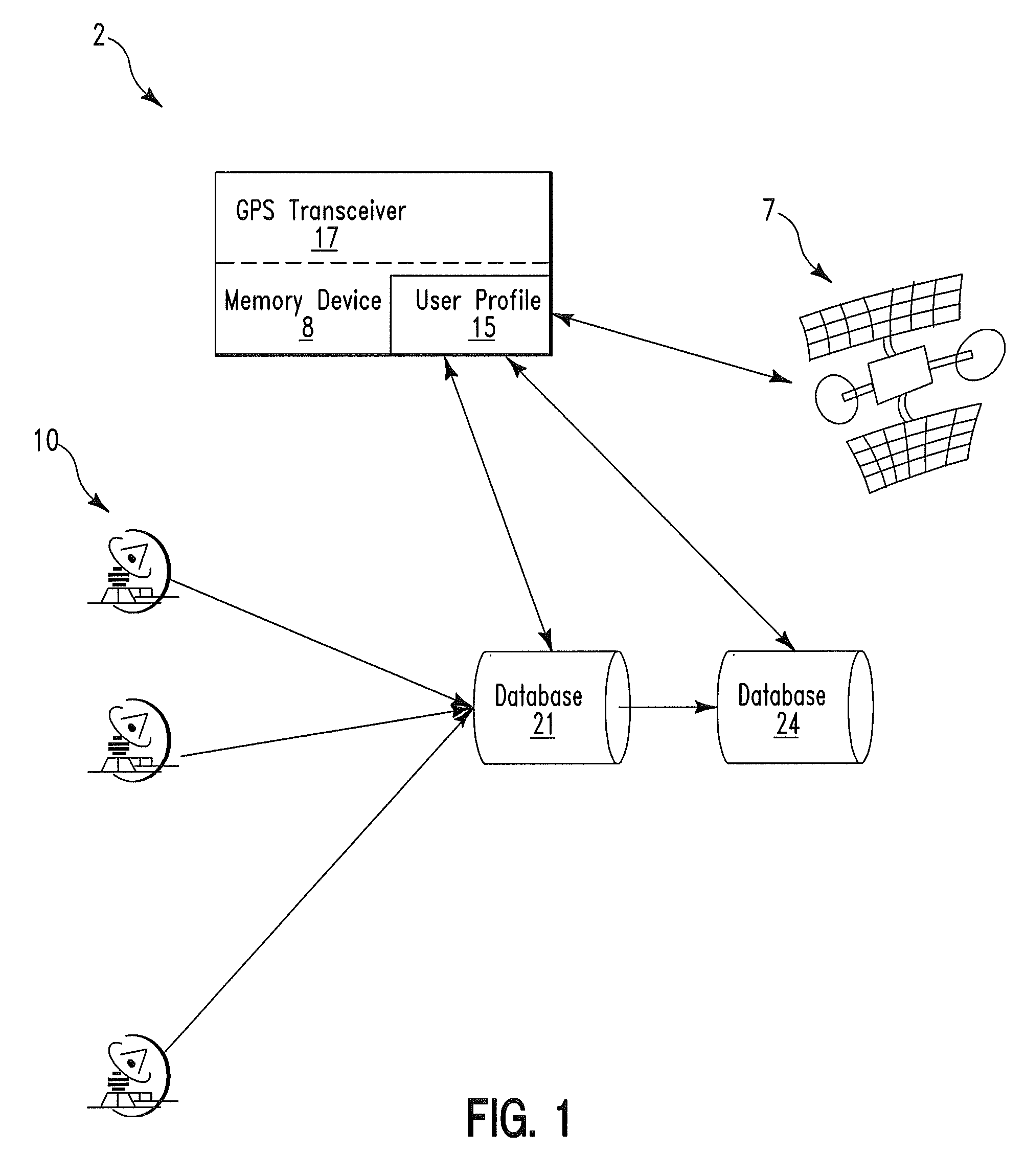
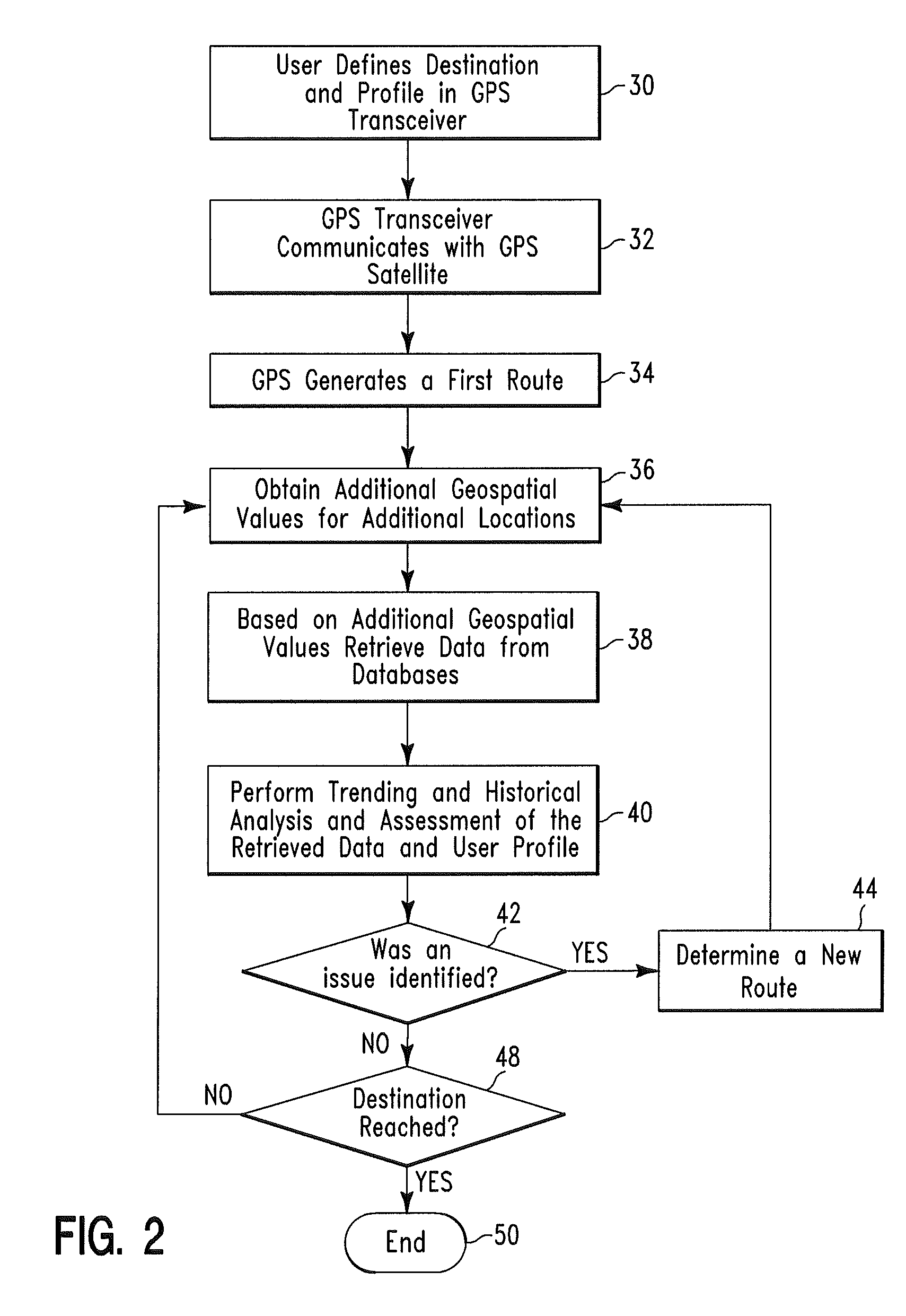
[0051]FIG. 1 illustrates an example of a block diagram of a system 2 for generating and modifying a geographical route of travel for a user, in accordance with embodiments of the present invention. System 2 comprises a global positioning satellite (GPS) transceiver 17, a GPS satellite 7, a database 21, a database 24, and a plurality of radar traffic speed / density receiving devices 10 (e.g., radar devices). Database 21 comprises real time current data comprising geospatial coordinate values, date, time, and traffic speed / density information associated with a plurality of geographical locations. The real time current data from database 21 is retrieved by radar traffic speed / density receiving devices 10 and transmitted to database 21 for storage and transmission to GPS device 17. Database 24 comprises historical (i.e., past) data comprising geospatial coordinate values (i.e., geospatial data) date, time, and traffic speed / density information associated with a plurality of geographical ...


PUM


Abstract

A routing method and system. The method includes receiving by a global positioning satellite (GPS) transceiver, a user profile comprising user preference data and destination location data. The GPS transceiver retrieves first geospatial coordinate values for a current location of the user and a destination location. The GPS transceiver processes the user profile and the first geospatial coordinate values to identify a geographical route for traveling from the current location to the destination location. The GPS transceiver retrieves current traffic speed / traffic density data and historical traffic speed / traffic density data associated with second geospatial coordinate values for various locations located along the first geographical route. The GPS transceiver processes the current traffic speed / traffic density data and the historical traffic speed / traffic density data to determine if the first geographical route comprises an efficient geographical route for the user.

Description

FIELD OF THE INVENTION[0001]The present invention relates to a method and associated system for generating and modifying a geographical route of travel for a user.BACKGROUND OF THE INVENTION[0002]Generating a custom map for a user typically requires a process that may be complicated and inaccurate. Accordingly, there exists a need in the art to overcome the deficiencies and limitations described herein above.SUMMARY OF THE INVENTION[0003]The present invention provides a routing method comprising:[0004]receiving from a user, by a global positioning satellite (GPS) transceiver, a user profile comprising user preference data;[0005]receiving from said user, by said GPS transceiver, destination location data defining a destination location for said user;[0006]retrieving from a satellite, by said GPS transceiver, first geospatial coordinate values for a current location of said user and second geospatial coordinate values for said destination location;[0007]first identifying, by said GPS ...

Claims


Application Information

Patent Timeline
Patent Type & Authority Patents(United States)
IPC IPC(8): G01C21/00
CPCG01C21/3415G01C21/3484G01C21/3492G08G1/096827G08G1/096838G08G1/096866G08G1/096888
Inventor VAUGHN, GARFIELD WINSTON
Owner LINKEDIN
Why Eureka
Try Eureka