System and method for managing geographical maplet downloads for a vehicle to support stop sign violation assist and similar applications

a technology for distributing geographic information and vehicles, applied in surveying and navigation, navigation instruments, instruments, etc., can solve the problems of time-consuming and costly continuous downloading of large amounts of information

Active Publication Date: 2012-11-06
GM GLOBAL TECH OPERATIONS LLC +1
View PDF22 Cites 4 Cited by
  • Summary
  • Abstract
  • Description
  • Claims
  • Application Information

AI Technical Summary

Problems solved by technology

However, the continuous download of large amounts of information is time consuming and costly.

Method used


Image

  • System and method for managing geographical maplet downloads for a vehicle to support stop sign violation assist and similar applications
  • System and method for managing geographical maplet downloads for a vehicle to support stop sign violation assist and similar applications
  • System and method for managing geographical maplet downloads for a vehicle to support stop sign violation assist and similar applications

Examples


Embodiment Construction

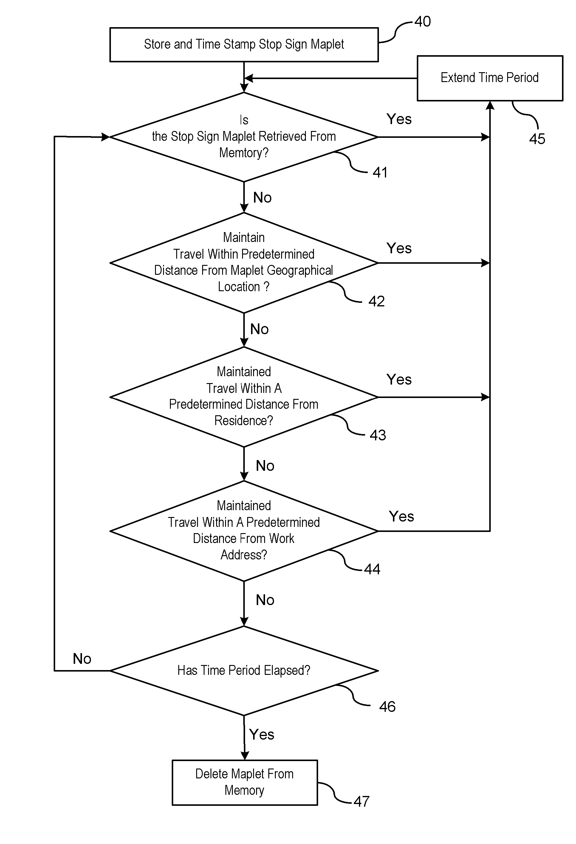
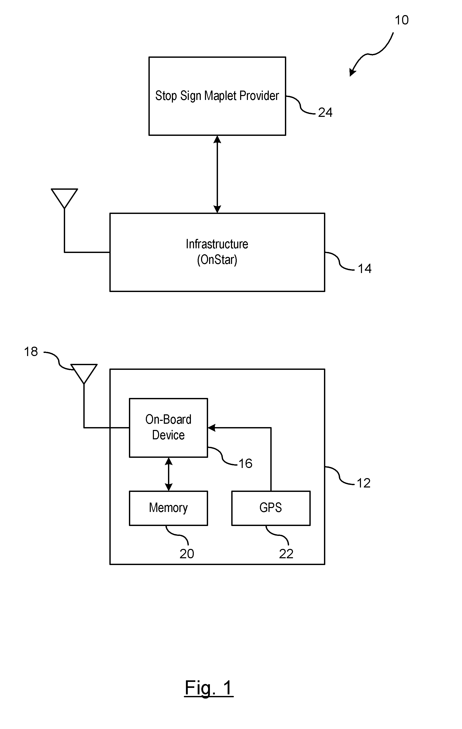
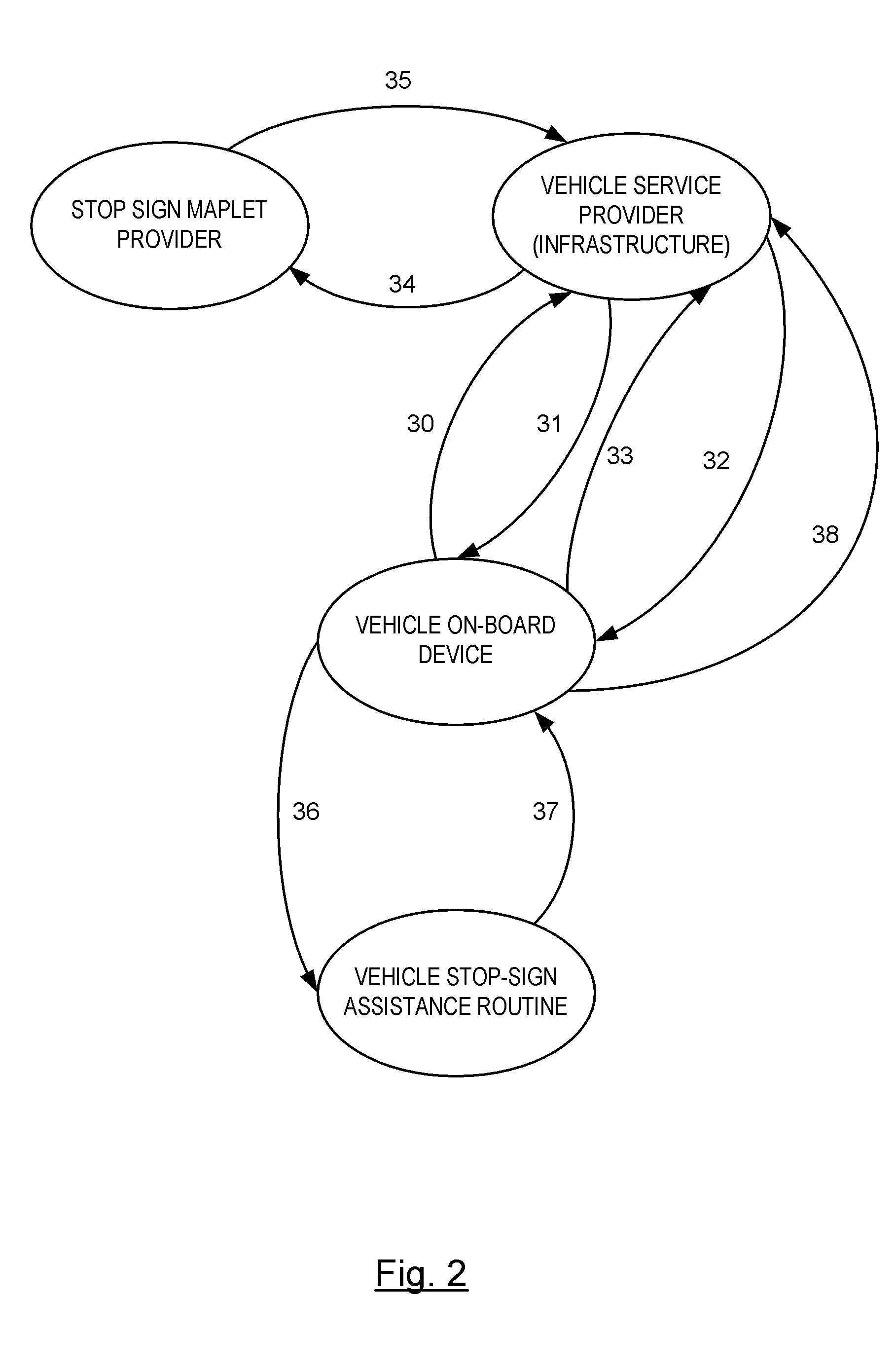
[0010]There is shown in FIG. 1, generally at 10, a system for managing a download of map data for stop sign intersection between a vehicle 12 and an infrastructure 14. The map data for stop sign intersection includes stops sign locations, map data of the approaching intersection, the designated stopping location of the approaching intersection, and the speed limit data of the traveled road, and other respective data associated with the stop sign intersection. It should also be understood that the term stop sign includes, but is not limited to, stop signal markings / indicators such as railroad crossing markings, yield signs, and a pedestrian crossing markings. In addition to the stop sign intersection data, road information such as curve locations, curve speed limits, and 1-way road information are also provided. The vehicle 12 is equipped with a stop sign assistance routine or signal violation warning routine which analyzes the vehicle speed and distance to a stopping location at a s...


PUM


Abstract

A method is provided for managing map data for intersections having stop sign indicators. A request is initiated for turn-by-turn navigation instructions for a destination from a vehicle to an infrastructure. A turn-by-turn navigation maplet is transmitted from the infrastructure to the vehicle. A geographical region associated with the received turn-by-turn navigation maplet is identified. A determination is made whether stop sign locations already retained within a memory of the vehicle relate to the identified geographical region. The vehicle on-board device requests stop sign maplets for the identified geographical regions from the infrastructure if the stop sign locations retained within the memory of the vehicle do not relate to the identified geographical region. The stop sign maplets are transmitted for the identified geographical region from the infrastructure to the vehicle. The stop sign maplets relate to stop sign intersection data within the identified geographical region.

Description

BACKGROUND OF INVENTION[0001]An embodiment relates generally to stop sign assistance and other application routines, and more specifically, to managing stop sign maplets and similar geographical information within a vehicle.[0002]Active safety and driver assistance features typically use a combination of multiple driver alert warning modalities to provide optimum and effective alerts to the driver of a vehicle in a timely manner. The timing of such alert modalities plays an important role in determining the effectiveness and user acceptance of these features. Such modalities utilize map data to determine the location of the vehicle in relation to a location of the safety event for determining whether the vehicle is affected by the safety event. Unless a vehicle already has the necessary map data stored in memory, large amounts of map data must be transferred between the infrastructure and the vehicle in particular when the map data of another geographical layout of roadways is requi...

Claims


Application Information

Patent Timeline
Patent Type & Authority Patents(United States)
IPC IPC(8): G01C21/36
CPCG01C21/3626G01C21/3667
Inventor MUDALIGE, UPALI PRIYANTHATENGLER, STEVEN C.
Owner GM GLOBAL TECH OPERATIONS LLC
Why Eureka
Try Eureka