Space-borne SAR image target positioning method capable of eliminating ground elevation errors

A target positioning, ground target technology, applied in the direction of reflection/re-radiation of radio waves, use of re-radiation, measurement devices, etc., can solve the large dependence of the earth model equation, the limited application scope of the geocoding model, and it is difficult to determine the ground height. And other issues

Inactive Publication Date: 2010-11-17
SHANGHAI UNIV
View PDF0 Cites 23 Cited by
  • Summary
  • Abstract
  • Description
  • Claims
  • Application Information

AI Technical Summary

Problems solved by technology

Therefore, the positioning accuracy of the ground target position has a great relationship with the accuracy of the earth model equation. The range-Doppler (R-D) positioning method is highly dependent on the earth model equation. In the absence of target area digital elevation model (DEM) In the case of data support, it is difficult to give an accurate earth model equation. Therefore, in many cases, it is difficult to determine the accurate ground height of the target, and it is impossible to give an accurate earth mod

Method used


Image

  • Space-borne SAR image target positioning method capable of eliminating ground elevation errors
  • Space-borne SAR image target positioning method capable of eliminating ground elevation errors
  • Space-borne SAR image target positioning method capable of eliminating ground elevation errors

Examples


Embodiment Construction

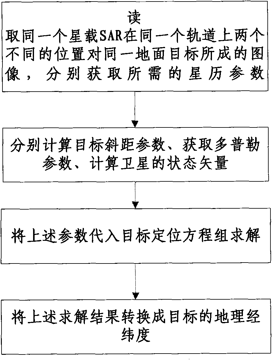
[0037] The implementation process of the present invention will be further described in detail below in conjunction with the accompanying drawings and specific embodiments.

[0038] The spaceborne SAR image target positioning method that can eliminate the ground elevation error of the present invention takes two SAR images with a size of 2048×4096 as an example,

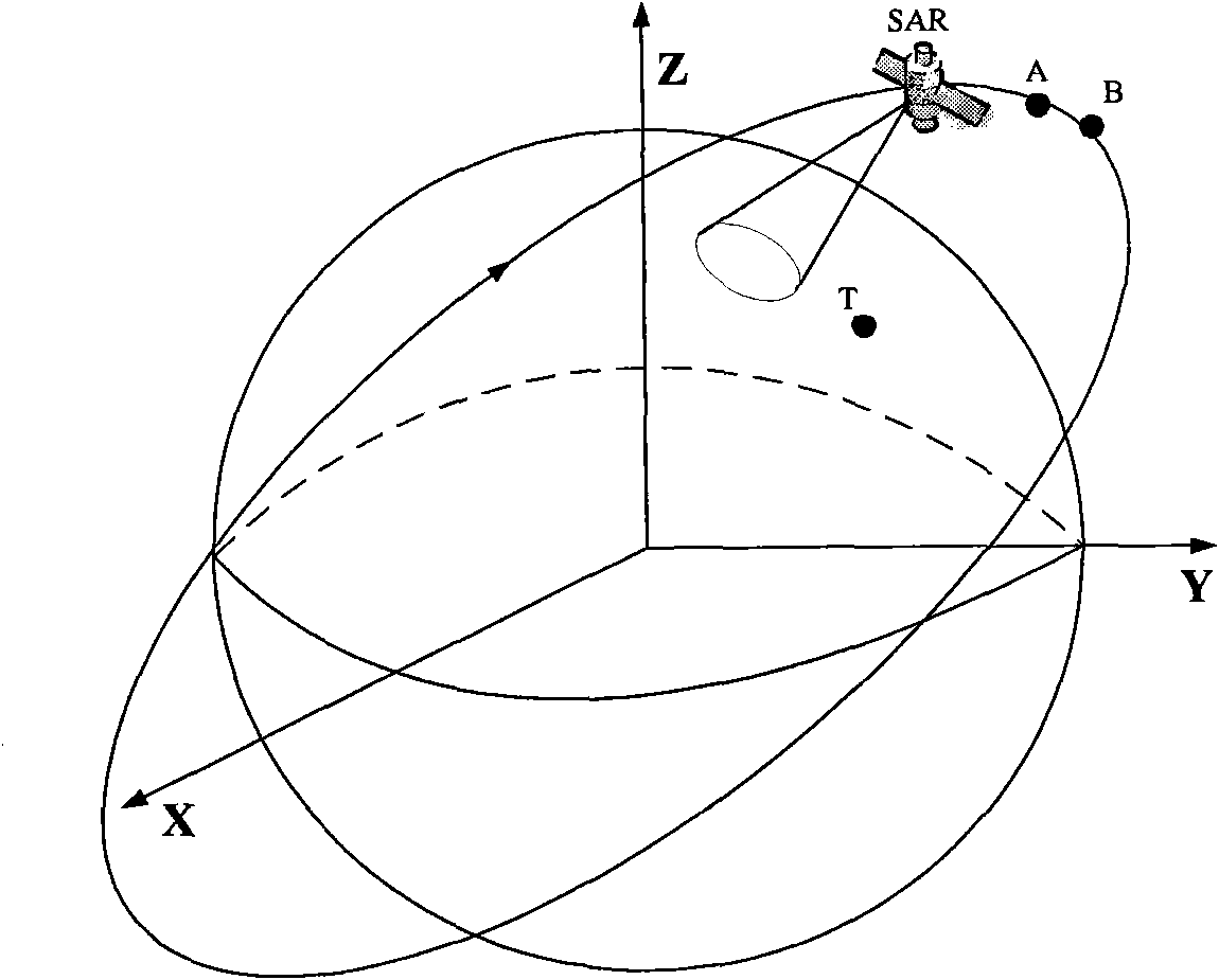
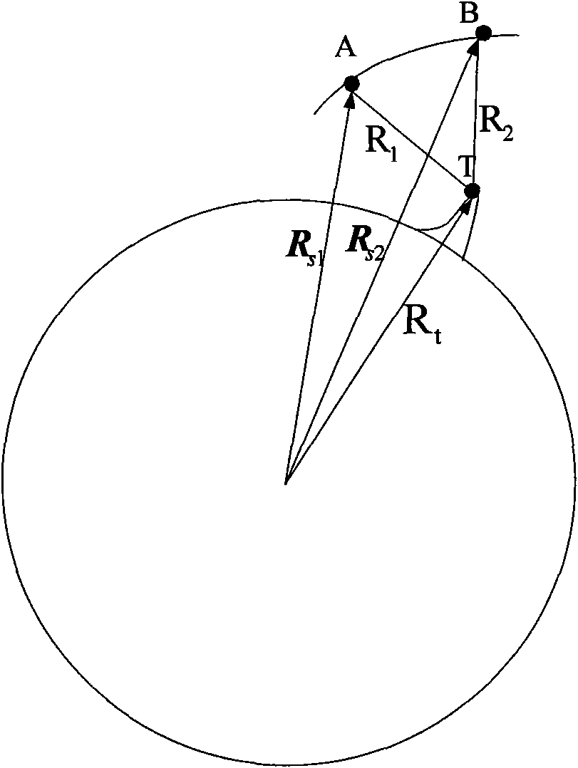
[0039] Such as figure 2 As shown, first, the same spaceborne SAR generates images for the same ground target position T at two different positions A and B on the same orbit; then, from the obtained two images of the same ground target position T, respectively, in The first and second slant range equations and the first and second Doppler frequency equations are obtained in the inertial geocentric Cartesian coordinate system, and the original target positioning quadruple equations composed of the above two slant range equations and two Doppler frequency equations , such as formula (1):

[0040] ...


PUM


Abstract

The invention discloses a space-borne SAR image target positioning method capable of eliminating ground elevation errors, comprising the following steps: (1) acquiring needed ephemeris parameters; (2) respectively calculating target slant-range parameters, Doppler parameters and state vectors of a satellite; (3) substituting the target slant-range parameters, the Doppler parameters and the state vectors in step (2) into a target positioning equations set, and then solving the equations set to obtain a ground target position; and (4) taking the x, y and z coordinates solved in step (3) as the coordinates under an inertial coordinate system, transforming the coordinates into a geocentric rotating coordinate system xc, yc and zc by a coordinate transformation mode, transforming the geocentric rotating coordinate system into geocentric longitude and latitude Lc and Deltac, and finally transforming the geocentric longitude and latitude into geographical longitude and latitude lon and lat. In the method, the target positioning equations set does not contain an earth model equation, thus eliminating positioning errors caused by the ground elevation errors, avoiding the difficult problem of solving a Range-Doppler (R-D) positioning equations set, and being beneficial to real-time processing of ground target positioning.

Description

Technical field: [0001] The invention relates to a target positioning method of a spaceborne SAR image, in particular to a target positioning method of a spaceborne SAR image capable of eliminating ground elevation errors, and belongs to the technical field of remote sensing image processing. Background technique: [0002] No matter in important fields related to national strategy such as remote sensing mapping and military reconnaissance, it is of great significance to carry out research on the positioning accuracy of ground targets in spaceborne SAR images. At present, there are several common methods for target positioning in spaceborne SAR images: observation triangulation model positioning method (FOT), digital stereo photogrammetry method and range-Doppler (R-D) positioning method. [0003] In addition to the range-Doppler (R-D) positioning method, the above-mentioned positioning methods are all based on the ground-air theory, that is, the geographical coordinates of t...

Claims


Application Information

Patent Timeline
IPC IPC(8): G01S13/90G01S13/06
Inventor 杨正得谢亚楠周星里耿辉王立树王波
Owner SHANGHAI UNIV
Why Eureka
Try Eureka