Remote multi-point monitoring system and method for subgrade surface settlement

A roadbed surface, multi-point monitoring technology, used in surveying and navigation, measuring devices, height/level measurement, etc., can solve the problems of inability to perform automatic measurement, difficulty in layout, and high power consumption of electric rotary tables.

Active Publication Date: 2011-02-16
BEIJING JIAOTONG UNIV
View PDF5 Cites 36 Cited by
  • Summary
  • Abstract
  • Description
  • Claims
  • Application Information

AI Technical Summary

Problems solved by technology

The above existing technologies generally have the following three main disadvantages: first, relying on manual measurement or recording, the measurement efficiency is low, and the detection accuracy is low; second, when selecting the reference point, stability and low cost cannot be achieved at the same

Method used


Image

  • Remote multi-point monitoring system and method for subgrade surface settlement
  • Remote multi-point monitoring system and method for subgrade surface settlement
  • Remote multi-point monitoring system and method for subgrade surface settlement

Examples


Embodiment 1

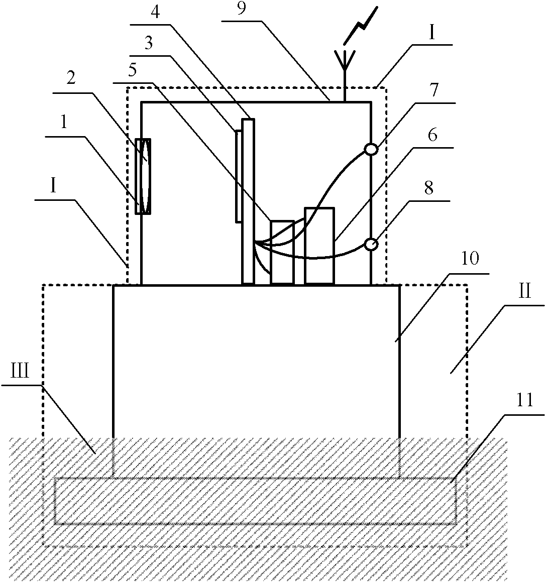
[0040] Such as figure 1 As shown, a subgrade surface settlement remote monitoring device with a light source is composed of a settlement measurement unit I with a light source and a settlement detection pile II. The settlement measurement unit I with a light source is installed on the settlement detection pile II, and the settlement detection pile II is buried at the point to be measured.

[0041] Subsidence measurement unit I with light source includes window glass 1, imaging lens 2, photoelectric position detector 3, signal processing circuit 4, power supply module 5, communication module 6, third point light source 7, fourth point light source 8, installation box 9 . The window glass 1 and the imaging lens 2 are embedded in the front wall of the installation box 9, and the optical axis of the window glass 1 coincides with the optical axis of the imaging lens 2; the third point light source 7 and the fourth point light source 8 are embedded in the rear wall of the installat...

Embodiment 2

[0056] Such as figure 1 As shown, the subgrade surface settlement remote monitoring device with a light source in this embodiment is the same as the first embodiment.

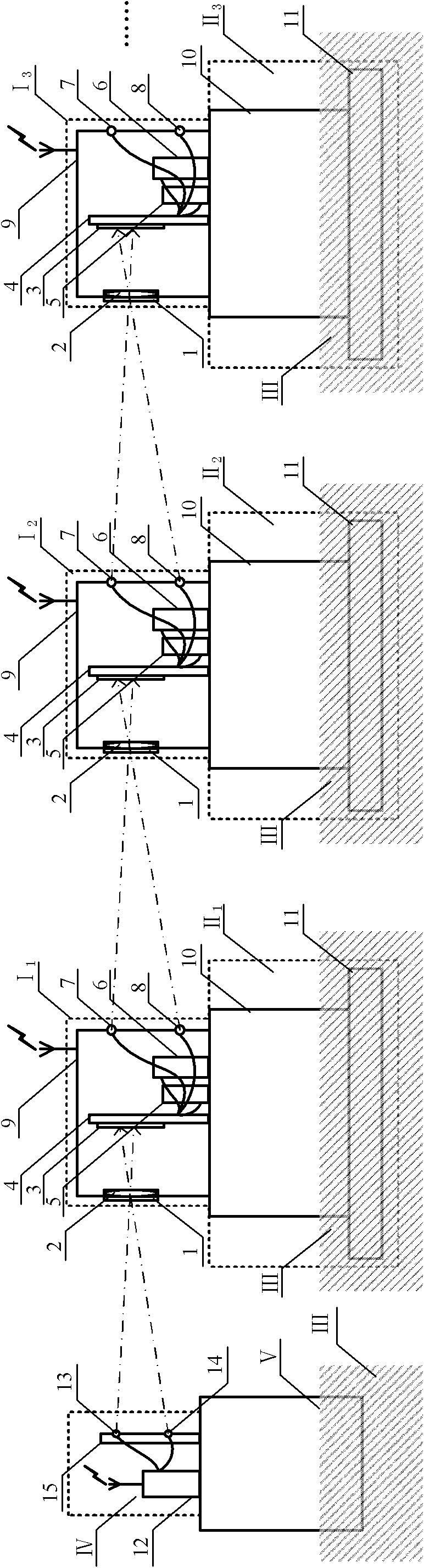
[0057] Such as Figure 4 As shown, the subgrade surface settlement remote multi-point monitoring system of this embodiment includes a central processing unit, a reference light source device located outside the subgrade settlement deformation zone as a source node, and multiple subgrade surface subsidence remote monitoring devices with light sources as a source node. Double chain structure of nodes. The only difference between the system of this embodiment and the first embodiment is the use of a double-chain structure.

[0058] A remote multi-point monitoring method for subgrade surface settlement in this embodiment is the same as that in Embodiment 1.

[0059] Beneficial effects of this embodiment On the basis of the first embodiment, the double chain structure is adopted, and the measurement range can be ...

Embodiment 3

[0061] Such as figure 1 As shown, the subgrade surface settlement remote monitoring device with a light source in this embodiment is the same as the first embodiment.

[0062] Such as Figure 5 As shown, an error compensation device, including a fixed observation post Ⅴ 1 ' and error compensation unit VI'.

[0063] Error compensation unit VI' includes window glass 1', imaging lens 2', photoelectric position detector 3', signal processing circuit 4', power module 5', communication module 6', installation box 9'; window glass 1' and imaging The lens 2' is embedded in the front wall of the installation box 9', and the optical axis of the window glass 1' coincides with the optical axis of the imaging lens 2'; the photoelectric position detector 3' is fixed on the signal processing circuit 4'; the signal processing circuit 4', the power module 5' and the communication module 6' are fixed in the installation box 9', and the signal processing circuit 4' is connected to the communi...


PUM


Abstract

The invention relates to a remote multi-point monitoring system and a remote multi-point monitoring method for subgrade surface settlement, which belong to the field of optical and geometric position measurement. The system comprises a central processing unit and a chain structure, wherein in the chain structure, a reference light source device is taken as a source node and a plurality of subgrade surface settlement remote monitoring devices which are provided with light sources and are positioned at measured points are taken as nodes. The method comprises the following steps of: measuring relative settlement of a previous device by using every monitoring device; accumulating to obtain the relative settlement of the device relative to the reference light source device; and tracing to the source of the reference light source device to a government benchmark to obtain the absolute settlement of the measured points. When the accuracy requirement is high, a traceable error compensation device can be arranged to form closed-loop measurement to modify accumulated errors. As the system does not need mechanical displacement and is low in power consumption during measurement, the system issuitable for an environment without alternating current supply outdoors; by the chain structure, the system realizes remote observation point traceability, and a uniform measurement reference is easyto establish; and the system modifies the accumulated errors during the measurement in a closed-loop mode to improve the measurement accuracy.

Description

technical field [0001] The invention belongs to the technical field of optical measurement and geometric position measurement, and relates to a remote multi-point monitoring system and method for subgrade surface settlement. Background technique [0002] Subgrade settlement measurement plays an important role in track safety detection and monitoring. At present, the observation devices used to measure road subgrade settlement mainly include water cup settlement instruments, settlement plate measuring devices, profile settlement instruments, PVC pipe settlement instruments, and magnetic ring settlement instruments. The above existing technologies generally have the following three main disadvantages: first, relying on manual measurement or recording, the measurement efficiency is low, and the detection accuracy is low; second, when selecting the reference point, stability and low cost cannot be achieved at the same time; third, the measurement cannot be remotely monitored. ,...

Claims


Application Information

Patent Timeline
IPC IPC(8): G01C5/00
Inventor 冯其波杨婧
Owner BEIJING JIAOTONG UNIV
Why Eureka
Try Eureka