Regional division method for satellite observation

An area division method and satellite observation technology, applied in the field of satellite observation, can solve the problems of reducing the observation efficiency of the target area, unable to give full play to the satellite observation ability, and unable to reflect the performance differences of different satellites.

An area division method and satellite observation technology, applied in the field of satellite observation, can solve the problems of reducing the observation efficiency of the target area, unable to give full play to the satellite observation ability, and unable to reflect the performance differences of different satellites.

CN102479289AInactive Publication Date: 2012-05-30NAT UNIV OF DEFENSE TECH

Image

  • Regional division method for satellite observation
  • Regional division method for satellite observation
  • Regional division method for satellite observation

Examples


Embodiment Construction

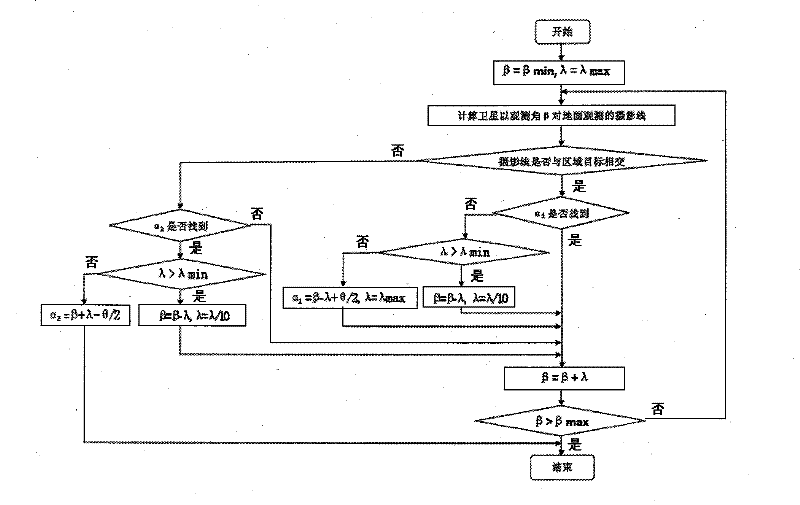
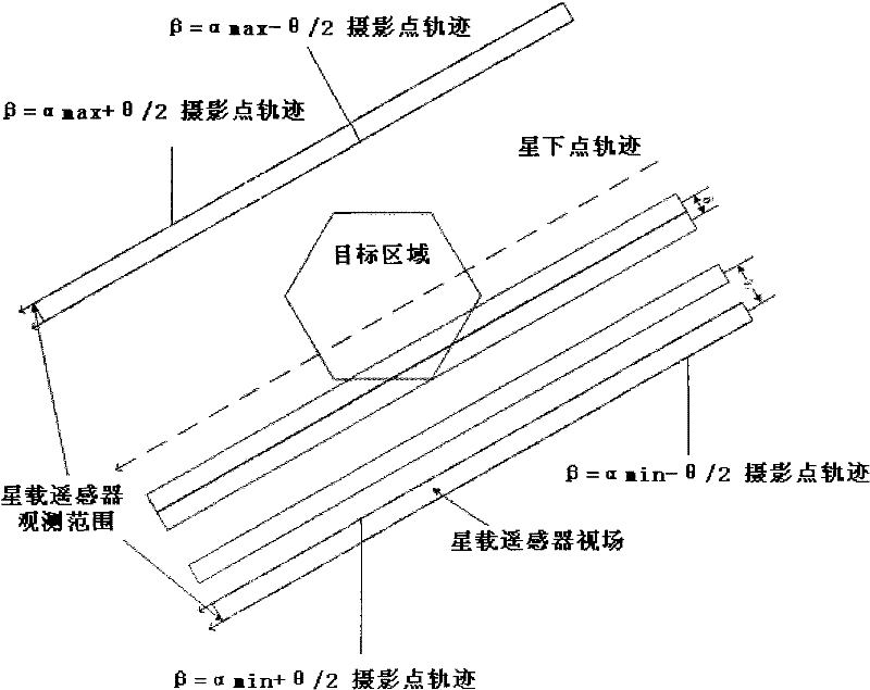
[0059] According to an embodiment of the present invention, the method for dividing the target area according to the performance parameters of the satellite and the flight radial direction includes the following steps: Step 1: According to the performance parameters of the satellite, it is determined that the satellite is effective for observing the target area. area. Step 2: Determine the minimum observed roll angle and the maximum observed roll angle corresponding to the effective area. Step 3: Initialize the current roll angle, so that the current roll angle is equal to the minimum observed roll angle, and initialize the result sub-region set, so that the result sub-region set is empty. Step 4: Update the result sub-area set, and add the current roll angle to the result sub-area set. Step 5: Update the current roll angle, so that the current roll angle increases, and the increase amount is equal to the set granularity angle. Step 6: Determine whether the sum of the curren...


PUM


Abstract

The invention provides a regional division method for satellite observation. The method comprises the follow steps of: step 1, determining the effective region of a target region; step 2, determining a maximum observation lateral swinging angle and a minimum observation lateral swinging angle corresponding to the effective region; step 3, making a current lateral swinging angle equal to the minimum observation lateral swinging angle, and emptying a result sub region set; step 4, adding the current lateral swinging angle into the result sub region set; step 5, adding a set granularity angle to the current lateral swinging angle; step 6, turning to step 4 if the sum of the current lateral swinging angle and the granularity angle is smaller than the maximum observation lateral swinging angle, and otherwise, turning to step 7; and step 7, adding the current lateral swinging angle into the result sub region set so that the effective region is divided into observation strip belts corresponding to each lateral swinging angle in the result sub region set. The regional division method overcomes the limitation of the Gaussian projection on task longitude differences, the accuracy is higher, and in addition, the regional division method is suitable for the target region observation by a plurality of satellites.

Description

technical field [0001] The invention relates to the technical field of satellite observation, in particular to an area division method for satellite observation (such as earth observation). Background technique [0002] According to the different types of ground targets, the research on imaging satellite scheduling problems can be divided into point target-oriented satellite scheduling problems (all observation targets are point targets) and target area-oriented satellite scheduling problems (observation targets are all target areas). kind. For the target area, the satellite usually cannot complete the observation in a single time, and it must be reasonably divided before the efficient observation can be carried out. [0003] The purpose of regional division is to divide a large area into multiple subtasks that can be completed by a single satellite at one time. At present, there are mainly the following four decomposition methods for the target area: ① transform the area ...

Claims


Application Information

Patent Timeline
30 May 2012
Publication
CN102479289A
IPC
G06F19/00
Inventors
李菊芳; 贺仁杰